
John Wesley Powell was an American geologist, U.S. Army soldier, explorer of the American West, professor at Illinois Wesleyan University, and director of major scientific and cultural institutions. He is famous for his 1869 geographic expedition, a three-month river trip down the Green and Colorado rivers, including the first official U.S. government-sponsored passage through the Grand Canyon.

The Colorado Plateau is a physiographic and desert region of the Intermontane Plateaus, roughly centered on the Four Corners region of the southwestern United States. This plateau covers an area of 336,700 km2 (130,000 mi2) within western Colorado, northwestern New Mexico, southern and eastern Utah, northern Arizona, and a tiny fraction in the extreme southeast of Nevada. About 90% of the area is drained by the Colorado River and its main tributaries: the Green, San Juan, and Little Colorado. Most of the remainder of the plateau is drained by the Rio Grande and its tributaries.

The Uinta Mountains are an east-west trending mountain range in northeastern Utah extending a short distance into northwest Colorado and slightly into southwestern Wyoming in the United States. As a subrange of the Rocky Mountains, they are unusual for being the highest range in the contiguous United States running east to west, and lie approximately 100 miles (160 km) east of Salt Lake City. The range has peaks ranging from 11,000 to 13,528 feet, with the highest point being Kings Peak, also the highest point in Utah. The Mirror Lake Highway crosses the western half of the Uintas on its way to Wyoming. Utah State Route 44 crosses the east end of the Uintas between Vernal and Manila.

Grove Karl Gilbert, known by the abbreviated name G. K. Gilbert in academic literature, was an American geologist.
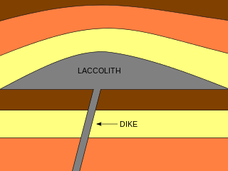
A laccolith is a body of intrusive rock with a dome-shaped upper surface and a level base, fed by a conduit from below. A laccolith forms when magma rising through the Earth's crust begins to spread out horizontally, prying apart the host rock strata. The pressure of the magma is high enough that the overlying strata are forced upward, giving the laccolith its dome-like form.

The Southern Paiute people are a tribe of Native Americans who have lived in the Colorado River basin of southern Nevada, northern Arizona, and southern Utah. Bands of Southern Paiute live in scattered locations throughout this territory and have been granted federal recognition on several reservations. Southern Paiute's traditionally spoke Colorado River Numic, which is now a critically endangered language of the Numic branch of the Uto-Aztecan language family, and is mutually intelligible with Ute. The term Paiute comes from paa and refers to their preference for living near water sources. Before European colonization, they practiced springtime, floodplain farming with reservoirs and irrigation ditches for corn, squash, melons, gourds, sunflowers, beans, and wheat.

William Henry Holmes, known as W. H. Holmes, was an American explorer, anthropologist, archaeologist, artist, scientific illustrator, cartographer, mountain climber, geologist and museum curator and director.
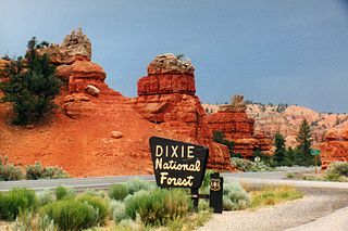
Dixie National Forest is a United States National Forest in Utah with headquarters in Cedar City. It occupies almost two million acres (8,000 km2) and stretches for about 170 miles (270 km) across southern Utah. The largest national forest in Utah, it straddles the divide between the Great Basin and the Colorado River. In descending order of forestland area it is located in parts of Garfield, Washington, Iron, Kane, Wayne, and Piute counties. The majority of forest acreage lies in Garfield County.

The Henry Mountains is a mountain range located in the southeastern portion of the U.S. state of Utah that runs in a generally north-south direction, extending over a distance of about 30 miles (48 km). They were named by Almon Thompson in honor of Joseph Henry, the first secretary of the Smithsonian Institution. The nearest town of any size is Hanksville, Utah, which is north of the mountains. The Henry Mountains were the last mountain range to be added to the map of the 48 contiguous U.S. states (1872), and before their official naming by Thompson were sometimes referred to as the "Unknown Mountains." In Navajo, the range is still referred to as Dził Bizhiʼ Ádiní.

Mount Ellen is a mountain located in Garfield County, Utah, United States.

John Karl Hillers was an American government photographer.
Gosiute is a dialect of the endangered Shoshoni language historically spoken by the Goshute people of the American Great Basin in modern Nevada and Utah. Modern Gosiute speaking communities include the Confederated Tribes of the Goshute Reservation and the Skull Valley Band of Goshute Indians.

Almon Harris Thompson, also known as A. H. Thompson, was an American topographer, geologist, explorer, educator and Civil War veteran. Often called "The Professor" or simply "Prof", Thompson is perhaps best known for being second in command of John Wesley Powell's Second Geographical Expedition (1871–1875), a federally funded scientific expedition that retraced the route of Powell's original expedition in order to further explore and map the drainages and canyons of the Green and Colorado Rivers in what is now southern Utah and northern Arizona. Thompson's diary of the expedition was originally published in the Utah Historical Quarterly in 1939. Through his work on the Powell expeditions and later as a geographer at the U.S. Geological Survey, he was responsible for naming many geographic locations in the Western United States. Thompson is also known for being a founding member of the National Geographic Society.

Mount Hillers is a summit in the Henry Mountains range, in Garfield County, Utah, in the United States. Its elevation is 10,741 feet (3,274 m) NAVD 88.
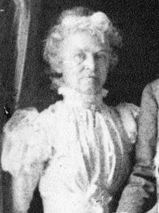
Ellen Louella (Nellie) Powell Thompson (1840–1911) was an American naturalist and botanist, and an active advocate for women's suffrage.

Mount Holmes is a 7,998-foot elevation summit located in eastern Garfield County, Utah, United States. Mount Holmes is part of the Henry Mountains. It is situated in a dry, rugged, and sparsely settled region west of Glen Canyon National Recreation Area, on primitive land administered by the Bureau of Land Management. Precipitation runoff from this mountain drains into tributaries of the nearby Colorado River, which here is Lake Powell six miles to the east of this mountain.

Bull Mountain is a 9,187-foot elevation summit located in northern Garfield County of Utah, United States. Bull Mountain is part of the Henry Mountains which are set between Capitol Reef National Park to the west, and Glen Canyon National Recreation Area to the east. Mount Ellen is immediately southwest of Bull Mountain, and Burr Desert spreads out to the northeast. It is situated in a dry, rugged, and sparsely settled region, set on primitive land administered by the Bureau of Land Management. Precipitation runoff from this mountain drains into tributaries of the Colorado River. The nearest town is Hanksville, 17 miles to the north, and Robbers Roost is 20 miles to the northeast.

Mount Ellsworth is an 8,235-foot elevation summit located in Garfield County, Utah, United States. Mount Ellsworth is part of the Henry Mountains. It is situated in a dry, rugged, and sparsely settled region west of Glen Canyon National Recreation Area, on primitive land administered by the Bureau of Land Management. Precipitation runoff from this mountain drains into tributaries of the nearby Colorado River, which here is Lake Powell eight miles to the east of this mountain.

Smithsonian Butte is a 6,780-foot (2,070 m) elevation summit located in the Canaan Mountain Wilderness of Washington County in southwest Utah, United States.

Mount Gilbert is a 13,106-foot (3,995 m) mountain located on the crest of the Sierra Nevada range in California, United States. It is situated on the shared boundary of Kings Canyon National Park and John Muir Wilderness, and along the common border of Fresno County and Inyo County. It is 18 miles (29 km) west of the community of Big Pine, 0.8 mile northwest of Mount Johnson, and one mile southeast of Mount Thompson, which is its nearest higher neighbor. Mount Gilbert ranks as the 127th-highest summit in California. Topographic relief is significant as the south aspect rises 3,900 feet (1,189 m) above LeConte Canyon in less than two miles, and the northern aspect rises 3,340 feet above South Lake in 2.5 miles.


