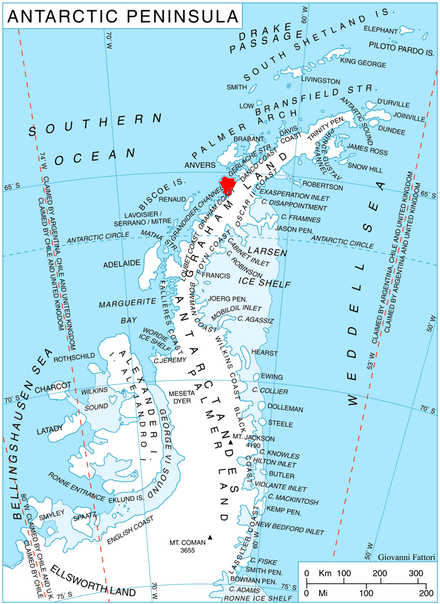
The history of Antarctica emerges from early Western theories of a vast continent, known as Terra Australis, believed to exist in the far south of the globe. The term Antarctic, referring to the opposite of the Arctic Circle, was coined by Marinus of Tyre in the 2nd century AD.

Sir Ernest Henry Shackleton was an Irish Antarctic explorer who led three British expeditions to the Antarctic. He was one of the principal figures of the period known as the Heroic Age of Antarctic Exploration.

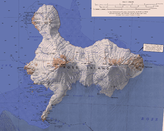
Ross Island is an island formed by four volcanoes in the Ross Sea near the continent of Antarctica, off the coast of Victoria Land in McMurdo Sound. Ross Island lies within the boundaries of Ross Dependency, an area of Antarctica claimed by New Zealand.

Mount Erebus is the second-highest volcano in Antarctica and the southernmost active volcano on Earth. It is the sixth-highest ultra mountain on the continent. With a summit elevation of 3,794 metres (12,448 ft), it is located in the Ross Dependency on Ross Island, which is also home to three inactive volcanoes: Mount Terror, Mount Bird, and Mount Terra Nova.

The Beardmore Glacier in Antarctica is one of the largest valley glaciers in the world, being 200 km (125 mi) long and having a width of 40 km (25 mi). It descends about 2,200 m (7,200 ft) from the Antarctic Plateau to the Ross Ice Shelf and is bordered by the Commonwealth Range of the Queen Maud Mountains on the eastern side and the Queen Alexandra Range of the Central Transantarctic Mountains on the western.

New Swabia was a disputed Antarctic claim by Nazi Germany within the Norwegian territorial claim of Queen Maud Land and is now a cartographic name sometimes given to an area of Antarctica between 20°E and 10°W in Queen Maud Land. New Swabia was explored by Germany in early 1939 and named after that expedition's ship, Schwabenland, itself named after the German region of Swabia.

The Queen Alexandra Range is a major mountain range of the Transantarctic Mountains System, located in the Ross Dependency region of Antarctica.

Alexandra Mountains is a group of low, separated mountains in the north portion of Edward VII Peninsula, just southwest of Sulzberger Bay in Marie Byrd Land, Antarctica. Discovered in January–February 1902 by the British National Antarctic Expedition during an exploratory cruise of the Discovery along the Ross Ice Shelf. Named for Alexandra, then Queen of the United Kingdom.

Canada Glacier is a small glacier flowing south-east into the northern side of Taylor Valley in Victoria Land, Antarctica. It is in the Ross Dependency. Its melting season is in the summer.

The Churchill Mountains are a mountain range group of the Transantarctic Mountains System, located in the Ross Dependency region of Antarctica. They border on the western side of the Ross Ice Shelf, between Byrd Glacier and Nimrod Glacier.

The Quartermain Mountains are a group of exposed mountains in Antarctica, about 32 kilometres (20 mi) long, typical of ice-free features of the McMurdo Dry Valleys, Victoria Land, located south of Taylor Glacier and bounded by Finger Mountain, Mount Handsley, Mount Feather and Tabular Mountain; also including Knobhead, Terra Cotta Mountain, New Mountain, Beacon Heights, Pyramid Mountain, Arena Valley, Kennar Valley, Turnabout Valley and the several valleys and ridges within Beacon Valley.

Hut Point Peninsula is a long, narrow peninsula from 3 to 5 km wide and 24 km (15 mi) long, projecting south-west from the slopes of Mount Erebus on Ross Island, Antarctica. McMurdo Station (US) and Scott Base (NZ) are Antarctic research stations located on the Hut Point Peninsula.

Cape Evans is a rocky cape on the west side of Ross Island, Antarctica, forming the north side of the entrance to Erebus Bay.

Barne Glacier is a steep glacier in Antarctica which descends from the western slopes of Mount Erebus and terminates on the west side of Ross Island, between Cape Barne and Cape Evans where it forms a steep ice cliff. It was discovered by the Discovery Expedition, 1901–04, under Robert Falcon Scott, and named by the British Antarctic Expedition, 1907–09, under Ernest Shackleton, after nearby Cape Barne, which itself is named after Michael Barne of Sotterley, Suffolk who was the second lieutenant during the Discovery Expedition.

The Scott Glacier is a major glacier, 120 miles (190 km) long, that drains the East Antarctic Ice Sheet through the Queen Maud Mountains to the Ross Ice Shelf. The Scott Glacier is one of a series of major glaciers flowing across the Transantarctic Mountains, with the Amundsen Glacier to the west and the Leverett and Reedy glaciers to the east.

Cape Crozier is the most easterly point of Ross Island in Antarctica. It was discovered in 1841 during James Clark Ross's expedition of 1839 to 1843 with HMS Erebus and HMS Terror, and was named after Francis Crozier, captain of HMS Terror. The extinct volcano Mount Terror, also named during the Ross expedition, rises sharply from the Cape to a height of 3,230 m (10,600 ft), and the edge of the Ross Ice Shelf stretches away to its east.

Ironside Glacier is a glacier, about 30 mi (48 km) long, originating at the south side of Mount Minto in the Admiralty Mountains and draining southeast between Mount Whewell and Mount Herschel into Moubray Bay, Victoria Land, Antarctica. At its mouth it is joined by the Honeycomb Glacier flowing in from the north.

Albanus Glacier, also known as Phillips Glacier, is a 25-nautical-mile long glacier flowing west along the south side of Tapley Mountains to enter Scott Glacier just north of Mount Zanuck, in the Queen Maud Mountains in Antarctica. It was discovered in December 1934 by the Byrd Antarctic Expedition geological party under Quin Blackburn. Byrd named it for Albanus Phillips, Jr., president of Phillips Packing in Cambridge, Maryland, a patron of, and supplier of provisions to, his Antarctic expeditions of 1928–30 and 1933–35.

The Southern CrossExpedition, otherwise known as the British Antarctic Expedition, 1898–1900, was the first British venture of the Heroic Age of Antarctic Exploration, and the forerunner of the more celebrated journeys of Robert Falcon Scott and Ernest Shackleton. The brainchild of the Anglo-Norwegian explorer Carsten Borchgrevink, it was the first expedition to over-winter on the Antarctic mainland, the first to visit the Great Ice Barrier—later known as the Ross Ice Shelf—since Sir James Clark Ross's groundbreaking expedition of 1839 to 1843, and the first to effect a landing on the Barrier's surface. It also pioneered the use of dogs and sledges in Antarctic travel.

Kukri Hills is a prominent east-west trending range, about 25 nautical miles (46 km) long and over 2,000 metres (6,600 ft) high, forming the divide between Ferrar Glacier on the south and Taylor Glacier and Taylor Valley on the north, in Victoria Land, Antarctica.


