
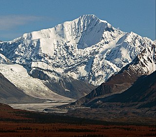
Mount Hayes is the highest mountain in the eastern Alaska Range, in the U.S. state of Alaska. Despite not being a fourteener, it is one of the largest peaks in the United States in terms of rise above local terrain. For example, the Northeast Face rises 8,000 feet (2,440 m) in approximately 2 miles (3.2 km). This large vertical relief contributes to Mount Hayes being the 51st most topographically prominent peak in the world.

Mount Brooks is a mountain peak in the central Alaska Range in Denali National Park and Preserve. The 11,890-foot (3,620 m) mountain is part of a ridge extending northeastward from the main Denali massif, which includes Pyramid Peak and Mount Silverthrone. The ridge lies between Brooks Glacier and Traleika Glacier, overlooking Muldrow Glacier to the north. The summit is partly covered by ice.

Mount Blachnitzky is a 6,552 ft (2,000 m) mountain summit in the city and borough of Juneau, Alaska, United States. It is a part of the Boundary Ranges of the Coast Mountains in western North America. It is located between Gilkey Glacier and Avalanche Canyon; it is named after Klaus Blachnitzky (1921-1988), a surveyor, geodesist, and explorer of the Juneau Icefield. Mr. Blachnitzky was the head surveyor for the Juneau Icefield Research Program. Much of his work was conducted in the vicinity of this summit. In August 1988, having completed almost two seasons instructing student surveyors and scientists in the science and practice of terrestrial field surveying and geodesy, he was killed when he slipped from a rock cleaver on the slope of Vaughan Lewis Glacier. The site of his death is four miles from the mountain named in his honor. In 2004, four climbers made a memorial climb of the previously unclimbed summit, leaving at the peak some surveying mementos of Mr. Blachnitzky's life. That first ascent was made by Scott McGee, Keith Daellenbach, Charles Daellenbach, and Fred Skemp III, on June 30, 2004, via the southwest cirque/south ridge. The mountain's name was officially adopted in 2007 by the U.S. Board on Geographic Names.

Mount Alice is a 5,318-foot (1,621 m) mountain summit in the U.S. state of Alaska.

Mount Cooper is a 6780-foot (2067-meter) mountain summit located in the Fairweather Range of the Saint Elias Mountains, in southeast Alaska. The peak is situated in Glacier Bay National Park and Preserve at the entrance to Johns Hopkins Inlet, 100 mi (161 km) northwest of Juneau, and 5.6 mi (9 km) northeast of Mount Abbe, which is the nearest higher peak. Although modest in elevation, relief is significant since the mountain rises up from tidewater in less than two miles. Mount Cooper can be seen from Johns Hopkins Inlet which is a popular destination for cruise ships. The mountain's name was proposed in the 1950s for William Skinner Cooper (1884-1978), a plant ecologist who performed vegetation-glacier relationship studies in the Glacier Bay area, and was chairman of the committee of scientists which proposed establishing Glacier Bay National Monument. The mountain's name was officially adopted in 1980 by the United States Geological Survey following Cooper's death. The months May through June offer the most favorable weather for climbing Mount Cooper.

Mount Bertha is a 10,204-foot (3,110-meter) glaciated mountain summit located in the Fairweather Range of the Saint Elias Mountains, in southeast Alaska, United States.

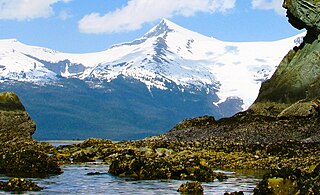
Mount Wordie is a 4,700+ foot mountain summit located in Glacier Bay National Park and Preserve, in the Alsek Ranges of the Saint Elias Mountains, in southeast Alaska. The mountain is situated 80 mi (129 km) northwest of Juneau, 4 mi (6 km) south of Carroll Glacier, and 3.1 mi (5 km) north of Mount Merriam which is the nearest higher peak. Although modest in elevation, relief is significant as the mountain rises up from tidewater in less than two miles. Precipitation runoff from the mountain drains into Glacier Bay Basin. Weather permitting, Mount Wordie can be seen from Queen Inlet and Wachusett Inlet of Glacier Bay, which is a popular destination for cruise ships.

Mount Huxley is a 12,216-foot glaciated mountain summit located in the Saint Elias Mountains of Wrangell-St. Elias National Park and Preserve, in the U.S. state of Alaska. The remote peak is situated 75 mi (121 km) northwest of Yakutat, and 8.7 mi (14 km) west-northwest of Mount Saint Elias. The peak rises above the Columbus Glacier and Bagley Icefield to its north, the Tyndall Glacier to the south, and the Yahtse Glacier to the west. Precipitation runoff from the mountain drains into the Gulf of Alaska. The mountain was named in 1886 by English mountaineer Harold Ward Topham for Thomas Henry Huxley (1825-1895), an English biologist. The mountain was officially named Huxley Peak in 1917, but the name was officially changed to Mount Huxley in 1968 by the U.S. Board on Geographic Names. The first ascent of the peak was made June 9, 1996 by Paul Claus who landed his plane at 11,500 feet elevation on the western flank and climbed the remaining distance to the summit. The second ascent of Mt. Huxley, and first complete ascent from base to summit, was made in June 2018 by Scott Peters, Andrew Peter, and Ben Iwrey starting from the Columbus Glacier.
Mount Witherspoon is a 12,012-foot-elevation glaciated summit located 36 mi (58 km) northwest of Valdez in the Chugach Mountains of the U.S. state of Alaska. It's set on land managed by Chugach National Forest. This remote mountain, fifth-highest in the Chugach range, is situated 4.33 mi (7 km) northwest of Mount Einstein, with the heads of Yale Glacier and Columbia Glacier between the summits. It is the second-highest peak in the Dora Keen Range, which is the 25-miles-long divide separating Harvard Glacier from Yale Glacier. The mountain's name was officially adopted in 1928 by the U.S. Board on Geographic Names to honor David C. Witherspoon, a U.S. Geological Survey topographer for 30 years, "who at the time of his retirement in 1921 had mapped a greater area of Alaska than any other man." The first ascent of Mount Witherspoon was made June 25, 1957, by David Bohn, Arthur Maki, Jr., Martin Mushkin, and Lawrence E. Nielsen.

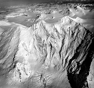
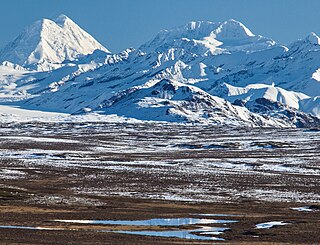
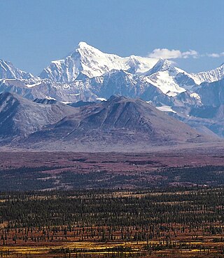
McGinnis Peak is an 11,400 ft (3,470 m) elevation glaciated summit located at the head of McGinnis Glacier in the eastern Alaska Range, in Alaska, United States. It is the eighth-highest peak in the Hayes Range, a subset of the Alaska Range. This remote peak is situated 14 mi (23 km) southeast of Mount Hayes, and 95 mi (153 km) southeast of Fairbanks. Mount Moffit, the nearest higher neighbor, is set 3.33 mi (5 km) to the northwest, and Mount Shand is positioned 4.5 mi (7 km) to the west. The Richardson Highway is 15 mi (24 km) to the east, with Hayes, McGinnis, and Moffit dominating the landscape along the drive south.

Mount Shand is a 12,660 ft (3,860 m) elevation glaciated summit located at the head of the Trident Glacier in the eastern Alaska Range, in Alaska, United States. It is the third-highest peak in the Hayes Range, a subset of the Alaska Range. This remote peak is situated 9.8 mi (16 km) east-southeast of Mount Hayes, and 93 mi (150 km) southeast of Fairbanks. Mount Moffit, the nearest higher neighbor, is set 2.3 mi (4 km) to the northeast, and McGinnis Peak is positioned 4.5 mi (7 km) to the east. This rarely climbed mountain has three large sweeping faces, the East, West, and South.
Hess Mountain, also known as Mount Hess, is an 11,940 ft (3,640 m) elevation glaciated summit located on the crest of the Alaska Range, in Alaska, United States. It is the seventh-highest peak in the Hayes Range which is a subrange of the Alaska Range. This remote peak is situated 13.3 mi (21 km) west of Mount Hayes, and 90 mi (145 km) south of Fairbanks. Mount Deborah, the nearest higher neighbor, is positioned 2.8 mi (5 km) to the west. Precipitation runoff from the mountain drains into tributaries of the Susitna and Tanana River drainage basins. The mountain's name was reported in 1912 by the United States Geological Survey. The first ascent was made May 24, 1951, by Alston Paige, Dick Holdren, Ed Huizer, Howard Bowman, and Elton Thayer. The first ascent via the North Ridge was made May 23, 1976, by Steven Hackett and Thomas Hillis.
Moby Dick is a 12,360 ft (3,770 m) elevation glaciated summit located at the head of the Trident Glacier in the eastern Alaska Range, in Alaska, United States. It is the fourth-highest peak in the Hayes Range, a subset of the Alaska Range. This remote peak is situated 5.7 mi (9 km) southeast of Mount Hayes, and 92 mi (148 km) southeast of Fairbanks. Mount Shand, the nearest higher neighbor, is set 4.7 mi (8 km) to the east. The first ascent of this unofficially named mountain was made in 1964 by Christopher Goetze, Lydia Goetze, Tom Knott, and Larry Muir.

Mount Nagishlamina is an 11,068-foot glaciated mountain summit located in the Tordrillo Mountains of the Alaska Range, in the US state of Alaska. The mountain is situated 90 mi (145 km) west of Anchorage, 7.4 mi (12 km) northwest of Mount Spurr, and 1.9 mi (3 km) southeast of Mount Torbert, which is the nearest higher neighbor. It is the fifth-highest peak in the Tordrillo Mountains, a subset of the Alaska Range. The mountain takes its Denaʼina language name from the Nagishlamina River which drains the west side of the peak. Mount Nagishlamina's name was in use by local mountaineers since the 1970s, and was officially adopted in 1999 by the U.S. Board on Geographic Names. This geographic feature was likely the highest unclimbed peak in the United States at the time of its first ascent in 1989 by Dave Johnston.
Mount Balchen is an 11,205-foot-elevation (3,415-meter) mountain summit in Alaska, United States.
Mount Sumdum is a 6,666-foot-elevation (2,032-meter) mountain summit in Alaska, United States.

Mount Gerdine is an 11,258-foot-elevation (3,431-meter) mountain summit in Alaska.
The Rowel is a 9,806-foot-elevation (2,989-meter) mountain summit in Alaska.

Mount Chichantna is a 10,893-foot-elevation (3,320-meter) mountain summit in Alaska.

Mount Geist is a 10,716-foot-elevation (3,266-meter) mountain summit in Alaska, United States.


