Hampden County is a non-governmental county located in the Pioneer Valley of the U.S. state of Massachusetts, in the United States. As of the 2020 census, Hampden County's population was 465,825. Its traditional county seat is Springfield, the Connecticut River Valley's largest city, and economic and cultural capital; with an estimated population of 154,758, approximately one-third of Hampden County residents live in Springfield.

Mount Holyoke, a traprock mountain, elevation 935 feet (285 m), is the westernmost peak of the Holyoke Range and part of the 100-mile (160 km) Metacomet Ridge. The mountain is located in the Connecticut River Valley of western Massachusetts, and is the namesake of nearby Mount Holyoke College. The mountain is located in the towns of Hadley and South Hadley, Massachusetts. It is known for its historic summit house, auto road, scenic vistas, and biodiversity. The mountain is crossed by the 110-mile (180 km) Metacomet-Monadnock Trail and numerous shorter trails. Mount Holyoke is the home of J.A. Skinner State Park which is accessible from Route 47 in Hadley, Massachusetts.

Chicopee is a city located on the Connecticut River in Hampden County, Massachusetts, United States. At the 2020 census, the city had a population of 55,560, making it the second-largest city in western Massachusetts after Springfield. Chicopee is part of the Springfield, Massachusetts Metropolitan Statistical Area. The communities of Chicopee Center (Cabotville), Chicopee Falls, Willimansett, Fairview, Aldenville, Burnett Road, Smith Highlands and Westover are located within the city.

Mount Charleston, including Charleston Peak at 11,916 feet (3,632 m), is the highest mountain in both the Spring Mountains and Clark County, in Nevada, United States. It is the eighth-highest mountain in the state. Well separated from higher peaks by large, low basins, Charleston Peak is the most topographically prominent peak in Nevada, and the eighth-most-prominent peak in the contiguous United States. It is one of eight ultra-prominent peaks in Nevada. It is located about 35 miles (56 km) northwest of Las Vegas within the Mount Charleston Wilderness, which is within the Spring Mountains National Recreation Area of the Humboldt–Toiyabe National Forest.
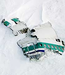
The Mount Erebus disaster occurred on 28 November 1979 when Air New Zealand Flight 901 (TE901) flew into Mount Erebus on Ross Island, Antarctica, killing all 237 passengers and 20 crew on board. Air New Zealand had been operating scheduled Antarctic sightseeing flights since 1977. This flight left Auckland Airport in the morning and was supposed to spend a few hours flying over the Antarctic continent, before returning to Auckland in the evening via Christchurch.

Alpine Air Express is an American airline based in Provo, Utah. It operates scheduled and chartered air cargo services on over 100 routes throughout Utah, Montana, Minnesota, Nebraska, North Dakota, South Dakota, Wyoming, Idaho, California, and Colorado.

Mount Tom, 1,202 feet (366 m), is a steep, rugged traprock mountain peak on the west bank of the Connecticut River 4.5 miles (7 km) northwest of downtown Holyoke, Massachusetts. The mountain is the southernmost and highest peak of the Mount Tom Range and the highest traprock peak of the 100-mile (160 km) long Metacomet Ridge. A popular outdoor recreation resource, the mountain is known for its continuous line of cliffs and talus slopes visible from the south and west, its dramatic 1,100-foot (340 m) rise over the surrounding Connecticut River Valley, and its rare plant communities and microclimate ecosystems.

Cebu Pacific Flight 387 was a domestic flight from Ninoy Aquino International Airport in Metro Manila to Lumbia Airport in Cagayan de Oro. On February 2, 1998, the 30-year-old McDonnell Douglas DC-9-32 crashed on the slopes of Mount Sumagaya in Claveria. All 104 people on board died in the crash. It is the second deadliest air disaster in the Philippines after Air Philippines Flight 541, which occurred two years later.
Westover Metropolitan Airport is a civilian airport located in the Massachusetts communities of Chicopee, Granby, South Hadley and Ludlow, near the cities of Springfield and Holyoke, Massachusetts. The complex is considered intermodal because it borders the Massachusetts Turnpike and is accessible by several industrial rail spurs. It was named for General Oscar Westover, commanding officer of the Army Air Corps in the 1930s.

BOAC Flight 911 was a round-the-world flight operated by the British Overseas Airways Corporation (BOAC) that crashed near Mount Fuji in Japan on 5 March 1966, with the loss of all 113 passengers and 11 crew members. The Boeing 707 flying the route disintegrated mid-air shortly after departing from Tokyo Haneda Airport as a result of severe clear-air turbulence.

The Holyoke Range or Mount Holyoke Range is a traprock mountain range located in the Connecticut River Valley of Massachusetts. It is a subrange of the narrow, linear Metacomet Ridge that extends from Long Island Sound near New Haven, Connecticut, north through the Connecticut River Valley of Massachusetts to the Vermont border. It is also a subrange of the Appalachian Mountains. A popular hiking destination, the range is known for its anomalous east–west orientation, high ledges and its scenic character. It is also notable for its unique microclimate ecosystems and rare plant communities, as well as significant historic sites, such as the Mount Holyoke Summit House and the Horse Caves.
Mount Tom Ski Area was a ski resort in Holyoke, Massachusetts, in the Mount Tom Range in the western part of Massachusetts about 10 miles north of Springfield. It opened in 1962 and closed in 1998. The slopes of the former ski area are located off U.S. Route 5 in the Smith's Ferry neighborhood of Holyoke, adjacent to the former Mountain Park, now a music venue.

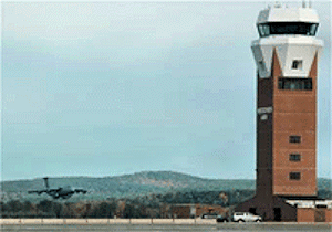
Westover Air Reserve Base is an Air Force Reserve Command (AFRC) installation located in the Massachusetts communities of Chicopee and Ludlow, near the city of Springfield, Massachusetts. Established at the outset of World War II, today Westover is the largest Air Force Reserve base in the United States, home to approximately 5,500 military and civilian personnel, and covering 2,500 acres (10 km²). Until 2011, it was a backup landing site for the NASA Space Shuttle and in the past few years has expanded to include a growing civilian access airport sharing Westover's military-maintained runways. The installation was named for Major General Oscar Westover who was commanding officer of the Army Air Corps in the 1930s.
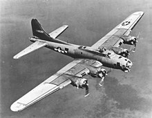
This is a partial list of accidents and incidents involving the Boeing-designed B-17 Flying Fortress. Combat losses are not included except for a very few cases denoted by singular circumstances. A few documented drone attrition cases are also included.
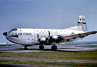
The 1952 Mount Gannett C-124 crash was an accident in which a Douglas C-124 Globemaster II military transport aircraft of the United States Air Force crashed into Mount Gannett, a peak in the Chugach Mountains in the American state of Alaska, on November 22, 1952. All of the 52 people on board were killed.

Juneau Mountain Rescue (JMR) is a mountain search and rescue agency, located in Juneau, Alaska, United States. JMR is a member of the Alaska Search and Rescue Association, and facilitates rescues involving wilderness terrain, rope rescues on rock faces, ice and snow fields, glaciers, and during avalanches, medical evacuations, missing persons cases, aircraft crashes and other disasters. An all-volunteer organization, JMR coordinates with Capital City Fire/Rescue, the Juneau Police Department, the Alaska State Troopers, the United States Coast Guard, and other emergency response agencies during search and rescue operations.

Smith's Ferry is a neighborhood in Holyoke, Massachusetts, United States, located to the north of the city center, approximately 1.5 miles (2.4 km) from downtown. The neighborhood prominently features the Mount Tom State Reservation, as well as the Mountain Park Amphitheater, the Dinosaur Footprints Reservation, and several other recreational and historic venues. Smith's Ferry is the second largest geographic division in Holyoke after Rock Valley, comprising roughly 3,800 acres (1,500 ha) of mixed residential, commercial, and recreational zoning.
The Holyoke Street Railway (HSR) was an interurban streetcar and bus system operating in Holyoke, Massachusetts as well as surrounding communities with connections in Amherst, Belchertown, Chicopee, Easthampton, Granby, Northampton, Pelham, South Hadley, Sunderland, Westfield, and West Springfield. Throughout its history the railway system shaped the cultural institutions of Mount Tom, being operator of the mountain's famous summit houses, one of which hosted President McKinley, the Mount Tom Railroad, and the trolley park at the opposite end of this funicular line, Mountain Park.