
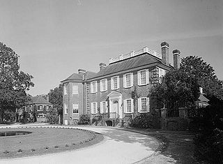
Drayton Hall is an 18th-century plantation house located on the Ashley River about 15 miles (24 km) northwest of Charleston, South Carolina, and directly across the Ashley River from North Charleston, west of the Ashley in the Lowcountry. An example of Palladian architecture in North America and the only plantation house on the Ashley River to survive intact through both the Revolutionary and Civil wars, it is a National Historic Landmark.

Johns Island is an island in Charleston County, South Carolina, United States, and is the largest island in the state of South Carolina. Johns Island is bordered by the Wadmalaw, Seabrook, Kiawah, Edisto, Folly, and James islands; the Stono and Kiawah rivers separate Johns Island from its border islands. It is the fourth-largest island on the US east coast, surpassed only by Long Island, Mount Desert Island and Martha's Vineyard. Johns Island is 84 square miles (220 km2) in area, with a population of 21,500.

The Fireproof Building, also known as the County Records Building, is located at 100 Meeting Street, at the northwest corner of Washington Square, in Charleston, South Carolina. Completed in 1827, it was the most fire-resistant building in America at the time, and is believed to be the oldest fire-resistant building in America today.

Edward Brickell White, also known as E. B. White, was an architect in the United States. He was known for his Gothic Revival architecture and his use of Roman and Greek designs.

This is a list of the National Register of Historic Places listings in Charleston County, South Carolina.
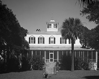
The Fenwick Hall, which is also known as Fenwick Castle, is a plantation house built about 1730 on Johns Island, South Carolina, across the Stono River from James Island and Charleston. It is located between River Road and Penneys Creek. It was named to the National Register of Historic Places on February 23, 1972.
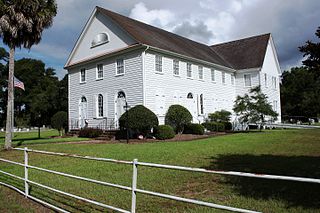
John's Island Presbyterian Church is a historic Presbyterian church located on Johns Island, Charleston County, South Carolina. It was founded in 1719 by Rev Archibald Stobo, a Church of Scotland minister. It was remodeled in 1792 and extended in 1823. It is a T-shaped, frame meeting house-style church sheathed in clapboard.

Botany Bay Heritage Preserve & Wildlife Management Area is a state preserve on Edisto Island, South Carolina. Botany Bay Plantation was formed in the 1930s from the merger of the Colonial-era Sea Cloud Plantation and Bleak Hall Plantation. In 1977, it was bequeathed to the state as a wildlife preserve; it was opened to the public in 2008. The preserve includes a number of registered historic sites, including two listed in the National Register of Historic Places: a set of three surviving 1840s outbuildings from Bleak Hall Plantation, and the prehistoric Fig Island shell rings.

Seaside Plantation House, also known as Locksley Hall, is a historic plantation house located at Edisto Island, Colleton County, South Carolina. It was built about 1810, and is a 2+1⁄2-story, Federal style brick dwelling with a gable roof. The house is one room deep with a long porch across the southeast elevation and sits on a raised basement. The central portion of the house is stuccoed brick with frame additions on the first floor.
Unnamed Battery No. 1 is an historic artillery battery located at Clark's Point, James Island, Charleston County, South Carolina. It was built in 1862 and was the southern end of the eastern James Island line. At the end of the war, this battery mounted two field guns. The earthen redoubt measures approximately 240 feet long and 200 feet wide. It has a 12 foot high parapet wall and a powder magazine about 17 feet in height.
The Progressive Club is a historic clubhouse located at Johns Island, Charleston County, South Carolina. The Club itself was formed in 1948. The club house was built in 1963, and provided a home for Esau Jenkins' Progressive Club's legal and financial assistance program, adult education program, and dormitory lodging. It also served as a community recreational, child care, meeting place and grocery store. The building was built to house a "Citizenship School" where adult education classes and workshops enabled African-American citizens to register, vote, and become aware of the political processes of their communities. It was listed on the National Register of Historic Places in 2007.
Hephzibah Jenkins Townsend's Tabby Oven Ruins is a historic archaeological site located at Edisto Island, Charleston County, South Carolina. The remains represent what was essentially a commercial bakery.

Oak Island, also known as the William Seabrook, Jr. House, is a historic plantation house located at Edisto Island, Charleston County, South Carolina. It was built about 1828–1831, and is a 2+1⁄2-story, five-bay, rectangular, central-hall, frame, weatherboard-clad residence with a projecting two-story rear pavilion. It features two, massive, interior chimneys with heavily corbelled caps and a one-story, wraparound hipped roof porch.
Sunnyside, also known as the Townsend Mikell House, is a historic plantation house located at Edisto Island, Charleston County, South Carolina. The main house was built about 1875, and is a 1+1⁄2-story, rectangular, frame, weatherboard-clad residence. It features a mansard roof topped by a cupola and one-story, hipped roof wraparound porch. Also on the property are the tabby foundation of a cotton gin; two small, rectangular, one-story, gable roof, weatherboard-clad outbuildings; a 1+1⁄2-story barn; and the Sunnyside Plantation Foreman's House. The Foreman's House is a two-story, weatherboard-clad, frame residence built about 1867.
McClellanville Historic District is a national historic district located at McClellanville, Charleston County, South Carolina. The district encompasses 105 contributing buildings in the town of McClellanville dating from ca. 1860 to ca. 1935. They include residential, commercial, religious and educational building dating between about 1860 to 1935. Architectural styles include: Carpenter Gothic, Queen Anne, and Italianate. The commercial strip developed in the early 20th century and are of frame construction built directly on the road. Notable buildings include the King Brothers Store, McClellanville Public School, New Wappetaw Presbyterian Church, Bank of McClellanville, McClellanville Methodist Episcopal Church, and a number of dwellings originally built as summer homes by St. James Santee and Georgetown planters.

Sullivan's Island Historic District is a national historic district located at Sullivan's Island, Charleston County, South Carolina. The district encompasses 36 contributing buildings on Sullivan's Island. They predominantly include the core residential and administrative areas of Fort Moultrie built between about 1870 to 1950. Also included are representative "Island Houses" and the Post Chapel. Notable buildings include the Base Commander's Quarters, nine Senior Officers' Quarters, ten Junior Officers' Quarters, the Bachelor Officers' Quarters, the Administration Building, the Post Exchange and Gymnasium, and the Electrical Shop.
Battery Tynes is a historic artillery battery located at James Island, Charleston, South Carolina. It was built in 1863, and designed to protect the upper Stono River and the bridge from James Island to Johns Island, South Carolina. The earthen redoubt measures approximately 320 feet long and 180 feet deep. It has a 10–20 foot high parapet wall and a 15 feet high powder magazine.
Battery No. 5 is a historic artillery battery located at James Island, Charleston, South Carolina. It was built in 1863, as part of the James Island Siege Line. At the close of the war it was armed with four guns. The earthen redoubt's left faces measuring about 200 feet and the center face about 100 feet. It has a 10 foot high parapet wall.
Fort Pringle is a historic artillery battery located at James Island, Charleston, South Carolina. It was built in 1863, as part of the James Island Siege Line and protect the Stono River, Johns Island and lower James Island. At the close of the war it was armed with nine heavy cannons. The earthen redoubt's river face measures approximately 360 feet, the right or upstream face 160 feet, the left or downstream face 400 feet, and the rear face approximately 520 feet in length. It has a 7.5 to 12.5 foot high parapet wall and 12.5 feet tall powder magazine.
Fort Trenholm, also known as Battery Trenholm, is a historic artillery battery located at Johns Island, Charleston, South Carolina. It was built in 1864, to reinforce Fort Pringle and protect the Stono River and Johns Island. It has emplacements for 17 guns. The three-sided earthen redoubt measures approximately 870 feet on its eastern face, 780 feet long on its southern face, and 885 feet long on its western face. It has a 15-foot-high parapet wall.


