
Missouri is a state in the Midwestern region of the United States. Ranking 21st in land area, it borders Iowa to the north, Illinois, Kentucky and Tennessee to the east, Arkansas to the south and Oklahoma, Kansas, and Nebraska to the west. In the south are the Ozarks, a forested highland, providing timber, minerals, and recreation. At 1.5 billion years old, the St. Francois Mountains are among the oldest in the world. The Missouri River, after which the state is named, flows through the center and into the Mississippi River, which makes up the eastern border. With over six million residents, it is the 19th-most populous state of the country. The largest urban areas are St. Louis, Kansas City, Springfield, and Columbia. The capital is Jefferson City.

Quercus marilandica, the blackjack oak, is a small oak, one of the red oak group Quercus sect. Lobatae. It is native to the eastern and central United States.
Baxter County is a county in the Ozark Mountains of Arkansas. Created as Arkansas's 66th county on March 24, 1873, the county has eight incorporated municipalities, including Mountain Home, its largest city and county seat. The county is named for Elisha Baxter, the tenth governor of Arkansas. It is coterminal with the Mountain Home Micropolitan Statistical Area.

Springfield is the third most populous city in the U.S. state of Missouri and the county seat of Greene County. The city's population was 169,176 at the 2020 census. It is the principal city of the Springfield metropolitan area, which had an estimated population of 487,061 in 2022 and includes the counties of Christian, Dallas, Greene, Polk, and Webster, The city sits on the Springfield Plateau of the Ozarks, which ranges from nearly-level to rolling hills. Springfield is the second-largest urban area in the Ozarks.

The Ozarks, also known as the Ozark Mountains, Ozark Highlands or Ozark Plateau, is a physiographic region in the U.S. states of Missouri, Arkansas, and Oklahoma, as well as a small area in the southeastern corner of Kansas. The Ozarks cover a significant portion of northern Arkansas and most of the southern half of Missouri, extending from Interstate 40 in central Arkansas to Interstate 70 in central Missouri.

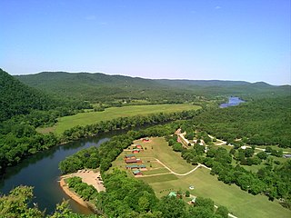
The Current River forms in the southeastern portion of the Ozarks of Missouri and becomes a 7th order stream as it flows southeasterly out of the Ozarks into northeastern Arkansas where it becomes a tributary of the Black River, which is a tributary of the White River, a tributary of the Mississippi River. The Current River is roughly 184 miles (296 km) long and drains about 2,641 square miles (6,840 km2) of land mostly in Missouri and a small portion of land in northeastern Arkansas. The headwaters of the Current River are nearly 900 feet (270 m) above sea level, while the mouth of the river lies around 280 feet (85 m) above sea level. The basin drains a rural area that is dominated by karst topography, underlain by dolomite and sandstone bedrock with a small area of igneous rock southeast of Eminence, Missouri. The annual daily mean discharge of the river near Doniphan, Missouri is 2,815 cubic feet (79.7 m3) per second. In 1964, over 134 mi (160 km) of the upper course of the river and its tributaries were federally protected as the Ozark National Scenic Riverways, the first national park in America to protect a river system.

Lake of the Ozarks is a reservoir created by impounding the Osage River in the northern part of the Ozarks in central Missouri. Parts of three smaller tributaries to the Osage are included in the impoundment: the Niangua River, Grandglaize Creek, and Gravois Creek. The lake has a surface area of 54,000 acres (220 km2) and 1,150 miles (1,850 km) of shoreline. The main channel of the Osage Arm stretches 92 miles (148 km) from one end to the other. The total drainage area is over 14,000 square miles (36,000 km2). The lake's serpentine shape has earned it the nickname "the Missouri Dragon", which has, in turn, inspired the names of local institutions such as the Magic Dragon Street Meet.

Meramec State Park is a public recreation area located near Sullivan, Missouri, about 60 miles from St. Louis, along the Meramec River. The park has diverse ecosystems such as hardwood forests and glades. There are over 40 caves located throughout the park, the bedrock is dolomite. The most famous is Fisher Cave, located near the campgrounds. The park borders the Meramec Conservation Area.
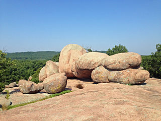
Elephant Rocks State Park is a geologic reserve and public recreation area encompassing an outcropping of Precambrian granite in the Saint Francois Mountains in the U.S. state of Missouri. The state park is named for a string of large granite boulders which resemble a train of pink circus elephants. The park was created following the donation of the land to the state in 1967 by geologist Dr. John Stafford Brown. The park is used for picnicking, rock climbing, and trail exploration. It is managed by the Missouri Department of Natural Resources.

Charles Mound is a gentle, 1,235-foot (376 m) high hill located in Scales Mound Township, Jo Daviess County, Illinois, United States. It is 2 miles (3.2 km) northeast of the small town of Scales Mound, and 11 miles (18 km) northeast of Galena. Despite its name, Charles Mound is a naturally occurring, erosional feature and is not to be confused with the intentional mounds created by native cultures. It is the highest natural point in the state and is thus considered a state highpoint. It is the lowest state highpoint in the Midwestern region of the United States.
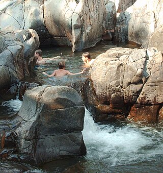
Johnson's Shut-Ins State Park is a public recreation area covering 9,432 acres (3,817 ha) on the East Fork Black River in Reynolds County, Missouri. The state park is jointly administered with adjoining Taum Sauk Mountain State Park, and together the two parks cover more than sixteen thousand acres in the St. Francois Mountains region of the Missouri Ozarks.

Hickory Run State Park is a 15,990-acre (6,471 ha) Pennsylvania state park in Kidder and Penn Forest Townships in Carbon County, Pennsylvania in the United States. The park is spread across the Pocono Mountains. The park is easily accessible from Interstate 476 and Interstate 80.

Washington State Park is a public recreation area covering 2,157 acres (873 ha) in Washington County in the central eastern part of the state of Missouri. It is located on Highway 21 about 14 miles (23 km) northeast of Potosi or 7 miles (11 km) southwest of De Soto on the eastern edge of the Ozarks. The state park is noted for its Native American rock carvings and for its finely crafted stonework from the 1930s.

The geology of Kansas encompasses the geologic history and the presently exposed rock and soil. Rock that crops out in the US state of Kansas was formed during the Phanerozoic eon, which consists of three geologic eras: the Paleozoic, Mesozoic and Cenozoic. Paleozoic rocks at the surface in Kansas are primarily from the Mississippian, Pennsylvanian, and Permian periods.

The geography of Arkansas varies widely. The state is covered by mountains, river valleys, forests, lakes, and bayous in addition to the cities of Arkansas. Hot Springs National Park features bubbling springs of hot water, formerly sought across the country for their healing properties. Crowley's Ridge is a geological anomaly rising above the surrounding lowlands of the Mississippi embayment.

The Ozark Highlands is a Level III ecoregion designated by the Environmental Protection Agency (EPA) in four U.S. states. Most of the region is within Missouri, with a part in Arkansas and small sections in Oklahoma and Kansas. It is the largest subdivision of the region known as the Ozark Mountains, less rugged in comparison to the Boston Mountains in Arkansas, the highest part of the Ozarks.
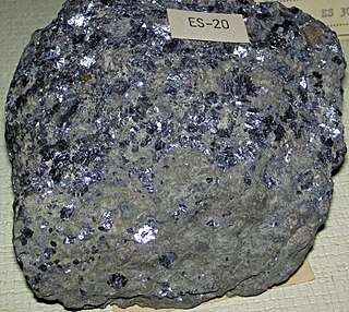
The Bonneterre Formation is an Upper Cambrian geologic formation which outcrops in the St. Francois Mountains of the Missouri Ozarks. The Bonneterre is a major host rock for the lead ores of the Missouri Lead Belt.
The Jefferson City Formation or Jefferson City Dolomite is a geologic formation in the Ozarks of Missouri and Arkansas. The Jefferson City is in part not differentiated from the Cotter Formation of northern Arkansas. It preserves fossils dating back to the Ordovician period.

Bryant Creek State Park is a 2,917-acre (1,180 ha) public recreation area located along Bryant Creek in south central Douglas County, 22 miles (35 km) southeast of Ava in the Ozarks of southern Missouri. The state park includes some two miles of the meandering channel of Bryant Creek, the dolomite and sandstone bluffs along the river, and the oak and pine forested land adjacent to the river. The park's two hiking trails offer 5.1 miles of trail. The park opened with a ribbon-cutting ceremony in September 2022. It was one of three new Missouri state parks announced in 2016.
The Hunton Megagroup also Hunton Super Group, Hunton Group, Hunton Formation and Hunton Limestone is predominantly composed of carbonate rock, deposited between the Silurian and early to mid Devonian periods. In many States it acts as a reservoir for both hydrocarbons and water.
