Mundic Creek, South Australia

Last updated

Mundic Creek
South Australia
Australia South Australia location map.svg
Red pog.svg
Mundic Creek
Coordinates 34°12′40″S140°47′07″E / 34.211023°S 140.785273°E / -34.211023; 140.785273 Coordinates: 34°12′40″S140°47′07″E / 34.211023°S 140.785273°E / -34.211023; 140.785273 [1]
Population 34 (2016 census) [2]
Established 16 March 2000 [3]
Postcode(s) 5340 [4]
Elevation 15 m (49 ft) [5]
Time zone ACST (UTC+9:30)
 • Summer (DST) ACST (UTC+10:30)
Location
LGA(s) Renmark Paringa Council [1]
Region Murray and Mallee [1]
County Alfred [1]
State electorate(s) Chaffey [6]
Federal Division(s) Barker [7]
Mean max temp [8] Mean min temp [8] Annual rainfall [8]
25.0 °C
77 °F
9.7 °C
49 °F
242.5 mm
9.5 in
Suburbs around Mundic Creek:
Paringa Paringa Wonuarra
Crescent Mundic Creek Wonuarra
Crescent Pike River Wonuarra
Footnotes Locations [1] [4]
Adjoining localities [1]

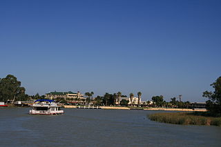
Mundic Creek is a locality in the Australian state of South Australia located in the Riverland in the state’s east on the southern side of the Murray River about 217 kilometres (135 mi) north-east of the state capital of Adelaide, and about 6 kilometres (3.7 mi) south-east of the municipal seat of Renmark. [1] [4]

South Australia State of Australia

South Australia is a state in the southern central part of Australia. It covers some of the most arid parts of the country. With a total land area of 983,482 square kilometres (379,725 sq mi), it is the fourth-largest of Australia's states and territories by area, and fifth largest by population. It has a total of 1.7 million people, and its population is the second most highly centralised in Australia, after Western Australia, with more than 77 percent of South Australians living in the capital, Adelaide, or its environs. Other population centres in the state are relatively small; Mount Gambier, the second largest centre, has a population of 28,684.

Riverland Region in South Australia

The Riverland is a region of South Australia. It covers an area of 9,386 square kilometres (3,624 sq mi) along the Murray River from where it flows into South Australia from New South Wales and Victoria downstream to Blanchetown. The major town centres are Renmark, Berri, Loxton, Waikerie, Barmera and Monash, along with many minor townships; the population is approximately 35,000 people.

Murray River the longest river in Australia

The Murray River is Australia's longest river, at 2,508 kilometres (1,558 mi) in length. The Murray rises in the Australian Alps, draining the western side of Australia's highest mountains, and then meanders across Australia's inland plains, forming the border between the states of New South Wales and Victoria as it flows to the northwest into South Australia. It turns south at Morgan for its final 315 kilometres (196 mi), reaching the ocean at Lake Alexandrina.

Its name and boundaries were created on 16 October 2000. [3] The name is derived from Mundic Creek, a stream which enters the Murray River from within the locality. [1]

Mundic Creek extends from the Murray River channel in the west to the Sturt Highway on higher ground in the east over a floodplain known in one source as the Pike River Basin and in another as the Pike Floodplain and which it shares with the localities of Paringa in the north and Pike River in the south. [1] [9] [10] Most of the floodplain located in what is now the locality was flooded by the 1956 Murray River flood and those parts existing as permanent water bodies are part of the nationally important wetland known as the Pike-Mundic Wetland Complex. [5] [11] [1]

Sturt Highway Australian national highway in New South Wales, Victoria, and South Australia

The Sturt Highway is an Australian national highway in New South Wales, Victoria, and South Australia. The Sturt Highway is an important road link for the transport of passengers and freight between Sydney and Adelaide and the regions situated adjacent to the route.

Floodplain Land adjacent to a stream or river which is flooded during periods of high discharge

A floodplain or flood plain is an area of land adjacent to a stream or river which stretches from the banks of its channel to the base of the enclosing valley walls, and which experiences flooding during periods of high discharge. The soils usually consist of levees, silts, and sands deposited during floods. Levees are the heaviest materials and they are deposited first; silts and sands are finer materials.

Paringa, South Australia Town in South Australia

Paringa is a small town in the Riverland of South Australia. Paringa is famous for its vineyards, almond, citrus and stone fruit orchards, and the steel bridge with a span that can be raised to allow houseboats and paddlesteamers to pass underneath and across the Murray River to Renmark. At the 2006 census, Paringa had a population of 946.

Land use within Mundic Creek and adjoining localities consists of ‘primary production’ activities such as agriculture, fishing, irrigation and sand mining, recreation activities concerned with watercraft, fishing and hunting, residential use, and nature conservation as represented by the Pike River Conservation Park. Land in the majority of the locality is either zoned as the ‘River Murray Flood Zone’ or the ‘River Murray Fringe Zone’ which makes it subject to statutory control for the purposes of “conservation and improvement of water quality” as per the River Murray Act 2003. [5] [11]

Pike River Conservation Park Protected area in South Australia

Pike River Conservation Park is a protected area located in the Australian state of South Australia in the locality of Mundic Creek about 215 kilometres (134 mi) north-east of the state capital of Adelaide and about 2 kilometres (1.2 mi) south of the town of Paringa.

The 2016 Australian census which was conducted in August 2016 reports that Mundic Creek had a population of 34 people. [2]

The 2016 Australian census was the seventeenth national population census held in Australia. The census was officially conducted with effect on Tuesday, 9 August 2016. The total population of the Commonwealth of Australia was counted as 23,401,892 – an increase of 8.8 per cent or 1,894,175 people since the 2011 census. Norfolk Island joined the census for the first time in 2016, adding 1,748 to the population.

Mundic Creek is located within the federal division of Barker, the state electoral district of Chaffey and the local government area of the Renmark Paringa Council. [7] [1] [6]

Division of Barker Australian federal electoral division

The Division of Barker is an Australian Electoral Division in the south-east of South Australia. The division was established on 2 October 1903, when South Australia's original single multi-member division was split into seven single-member divisions. It is named for Collet Barker, an early explorer of the region at the mouth of the Murray River. The 63,886 km² seat currently stretches from Morgan in the north to Port MacDonnell in the south, taking in the Murray Mallee, the Riverland, the Murraylands and most of the Barossa Valley, and includes the towns of Barmera, Berri, Bordertown, Coonawarra, Keith, Kingston SE, Loxton, Lucindale, Mannum, Millicent, Mount Gambier, Murray Bridge, Naracoorte, Penola, Renmark, Robe, Tailem Bend, Waikerie, and parts of Nuriootpa and Tanunda.

Electoral district of Chaffey state electoral district of South Australia

Chaffey, created in 1936, is a single-member electoral district for the South Australian House of Assembly. It covers the Riverland region of South Australia including the towns of Renmark, Berri, Barmera, Loxton and Waikerie. The seat is named after brothers George and William Chaffey who established the irrigation area along the Murray River from 1886.

Renmark Paringa Council Local government area in South Australia

The Renmark Paringa Council is a local government area located adjacent to the Victorian border, in the Riverland, South Australia. The area is known for its various fruit production, and is heavily dependent on the River Murray as a water source. The council seat is at Renmark.

Related Research Articles

Renmark, South Australia Town in South Australia

Renmark is a town in South Australia's rural Riverland area, and is located 254 km northeast of Adelaide, on the banks of the River Murray. The Sturt Highway between Adelaide and Sydney runs through the town; Renmark is the last major town encountered in South Australia when driving this route. It is 31 m above sea level. At the 2011 census, Renmark had a population of 7,491.

Blanchetown Town in South Australia

Blanchetown is a small township in South Australia, on the (west) bank of the Murray River, 130 km northeast of Adelaide. The Blanchetown Bridge is the western-most of the four crossings of the Sturt Highway over the Murray River. During the nineteenth century it was an important transportation centre on the lower Murray. In modern times Blanchetown has been described as "a strange mixture of historic buildings and temporary shacks built by holidaymakers on the banks of the river". Blanchetown is widely regarded as the entrance to the Riverland district.

Cadell, South Australia Town in South Australia

Cadell is a town and locality situated near the north western edge of South Australia's Riverland on the inside of the large southward bend in the Murray River. It is named after Captain Francis Cadell, a pioneer of steam-powered navigation on the Murray River. The town of Cadell was surveyed in 1919 and named in 1920. It is slightly upstream of the earlier failed village settlement of New Era, however what is now the Cadell Irrigation Area is the same as was previously the New Era irrigation area.

Nildottie, South Australia Suburb of Mid Murray Council, South Australia

Nildottie is a locality in the Australian state of South Australia located on the east side of the Murray River about 99 kilometres (62 mi) east of the state capital of Adelaide and about 40 kilometres (25 mi) north-east of the municipal seat in Mannum.

Cooltong, South Australia Town in South Australia

Cooltong is a town and locality in the Australian state of South Australia. At the 2011 census, Cooltong had a population of 317.

Ramco, South Australia Town in South Australia

Ramco is a town in the Riverland region of South Australia 170 kilometres (110 mi) north-east of the state capital, Adelaide and 7 kilometres (4.3 mi) west of Waikerie. At the 2016 census, Ramco had a population of 166. It is on the south (left) bank of the Murray River downstream from Waikerie.

Overland Corner Town in South Australia

Overland Corner is a locality in the Australian state of South Australia located in the state’s east about 181 kilometres (112 mi) north-east of the state capital of Adelaide and about 30 kilometres (19 mi) west of the municipal seat in Berri.

Chowilla, South Australia South Australia

Chowilla is a locality in the Australian state of South Australia located on the northern side of the Murray River about 250 kilometres to the north-east of the capital city of Adelaide and about 40 kilometres to the north-east of the town of Renmark, and which is bounded by the border with New South Wales in the east.

Katarapko, South Australia Suburb of Berri Barmera Council, South Australia

Katarapko is a locality in the Australian state of South Australia located in the Riverland about 188 kilometres north-east of the state capital of Adelaide and about 6.6 kilometres (4.1 mi) north of Loxton.

Spectacle Lake, South Australia Suburb of Unincorporated area, South Australia

Spectacle Lake is a locality in the Australian state of South Australia located in the Riverland on the northern side of the Murray River about 180 kilometres north-east of the Adelaide city centre and about 16 kilometres (9.9 mi) northwest of Loxton. Its boundaries were created in August 1999 along with the selection of its name which was derived from the Spectacle Lakes, a lake system which is situated within the locality on the floodplain of the Murray River. In 2014, a portion of Spectacle Lake was removed and added to the adjoining locality of Loveday to ensure the full extent of Nynes Island is within Loveday. As of 2012, the land use within Spectacle Lake was divided between conservation and agriculture with the former being concerned with the floodplain. Spectacle Lake is located within the federal division of Barker, the state electoral district of Chaffey and the unincorporated area of South Australia.

Gerard, South Australia Suburb of Pastoral Unincorporated Area, South Australia

Gerard is a locality in the Australian state of South Australia located in the Riverland on the northern side of the Murray River about 182 kilometres north-east of the state capital of Adelaide and about 12 kilometres (7.5 mi) northwest of Loxton.

Goolwa North, South Australia Suburb of Alexandrina Council, South Australia

Goolwa North is a locality in the Australian state of South Australia located about 66 kilometres south of the state capital of Adelaide and 2.5 kilometres northeast of the centre of the municipal seat of Goolwa overlooking the following water bodies in the Murray River system - Currency Creek to the north and the channel known as Goolwa or the Lower Murray to the south-east.

Sunlands, South Australia Town in South Australia

Sunlands is a locality on the left bank of the Murray River, 10 kilometres (6.2 mi) west of Waikerie, South Australia. The Waikerie Golf and Country Club course is in Sunlands.

Wombats Rest, South Australia Suburb of Mid Murray Council, South Australia

Wombats Rest is a locality in the Australian state of South Australia located in the state’s east on the western side of the Murray River about 133 kilometres (83 mi) north-east of the state capital of Adelaide and about 94 kilometres (58 mi) north-east of the municipal seat of Mannum.

McBean Pound, South Australia Suburb of Mid Murray Council, South Australia

McBean Pound is a locality in the Australian state of South Australia located in the Riverland in the state’s east on the western side of the Murray River about 118 kilometres (73 mi) north-east of the state capital of Adelaide about 76 kilometres (47 mi) north-east of the municipal seat of Mannum.

Pike River, South Australia Suburb of Renmark Paringa Council, South Australia

Pike River is a locality in the Australian state of South Australia located in the Riverland in the state’s east on the southern side of the Murray River about 210 kilometres (130 mi) north-east of the state capital of Adelaide and about 9 kilometres (5.6 mi) south-east of the municipal seat of Renmark.

Pooginook, South Australia Suburb of District Council of Loxton Waikerie, South Australia

Pooginook is a locality in the Australian state of South Australia located in the state’s east about 167 kilometres (104 mi) north-east of the state capital of Adelaide and about 60 kilometres (37 mi) north-west of the municipal seat in Loxton.

References

  1. 1 2 3 4 5 6 7 8 9 10 11 "Search result for Mundic Creek, LOCB' with the following datasets selected - 'Local Government areas', 'SA Government Regions', 'Counties', 'Postcode', 'Suburbs and Localities', 'Land Development Plan Zone Categories', 'Roads', 'Railways' and 'Gazetteer'" . Retrieved 27 March 2018.
  2. 1 2 Australian Bureau of Statistics (27 June 2017). "Mundic Creek". 2016 Census QuickStats. Retrieved 27 March 2018. Blue pencil.svg
  3. 1 2 "GEOGRAPHICAL NAMES ACT 1991, Notice to Assign Boundaries and Names to Places (to areas within the District Council of Renmark Paringa)" (PDF), The South Australian Government Gazette: 1433, 16 March 2000, retrieved 27 March 2018
  4. 1 2 3 "Postcode for Mundic Creek, South Australia". Postcodes Australia. Retrieved 27 March 2018.
  5. 1 2 3 "Search result for Pike-Mundic Wetland Complex (SA047)". Australian Wetlands Database. Department of Environment and Energy, Australian Government. 10 May 2010. Retrieved 27 March 2018.
  6. 1 2 "Electoral district of Chaffey". Electoral Commission SA. Retrieved 27 March 2018.
  7. 1 2 "Electoral division of Barker" (PDF). Australian Electoral Commission. Retrieved 27 March 2018.
  8. 1 2 3 "Monthly climate statistics: Summary statistics Summary statistics RENMARK AERO (nearest weather station)". Commonwealth of Australia , Bureau of Meteorology. Retrieved 27 March 2018.
  9. Hollis, B.A.; Fordham, A.E.; Thompson R, .A. (January 2011). "Pike Implementation Plan. Report prepared for Department for Water" (PDF). The Department for Water, South Australia. p. 9. Retrieved 27 March 2018.
  10. "Pike River Basin, listing on the now-defunct Register of the National Estate (Place ID 7859)". Australian Heritage Database . Department of the Environment. 21 October 1980. Retrieved 27 March 2018.
  11. 1 2 "Development Plan - Renmark Paringa Council, Consolidated – 31 October 2017" (PDF). South Australian Government. pp. 171, 179, 223, 275–279. Retrieved 27 March 2018.