
Talarn is a municipality in the comarca of the Pallars Jussà in Catalonia, Spain. It is situated in the centre of the Tremp basin, on the Noguera Pallaresa river below the Sant Antoni reservoir. It is the site of a hydroelectric power station and of a training school of the Spanish army. The town is served by the C-147 road between Tremp and La Pobla de Segur.

Cornellà de Llobregat is a municipality in the comarca of the Baix Llobregat in Catalonia, Spain. It is situated on the left bank of the Llobregat River. It is in the south-western part of the Barcelona metropolitan area and is part of the wider urban area. It houses one of the two La Liga football clubs from Catalonia, RCD Espanyol.

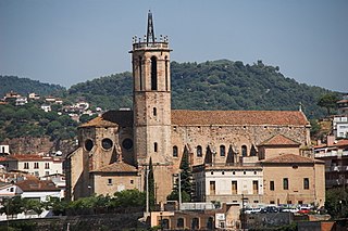
Santa Coloma de Farners is a spa town and capital of the comarca of the Selva, in Catalonia, Spain, and of the judicial district of Santa Coloma. It is situated on the edge of the Selva Depression and of the Guilleries. The local economy is mainly commercial, given the status of the town as capital of the comarca, although summer tourism, agriculture and forestry products also contribute. The urban centre is to the north and west of the main modern communication routes, although the C-253 road links the town with the main N-II route and the AP-7 autopista and to the RENFE railway station at Sils (10 km). The GE-533 runs through the northern part of the municipality, linking it with Vic to the west and with Riudellots de la Selva, Vilobí d'Onyar and Girona-Costa Brava Airport to the east.

Òdena is a municipality in the comarca of the Anoia in Barcelona province, Catalonia, Spain. It is situated in the centre of the Òdena Basin, on the side of a small hill. The remains of Òdena castle with its octagonal tower are at the top of the hill. The town is served by the C-241 road from Igualada to Manresa, and the main N-II road from Barcelona to Lleida runs through the municipality.

Pallejà is a municipality in the comarca of the Baix Llobregat in Catalonia, Spain. It is situated on the right bank of the Llobregat river, on the main N-II road. The main rail lines of the Llobregat corridor pass through the town: the station is served by the FGC services R5/R50, R6, S4 and S8. Pallejà castle was built in the seventeenth century on the site of an older fortress; it currently houses a library.

Bassella is a municipality in the comarca of the Alt Urgell, in Catalonia, Spain. The village of Bassella, one of nine settlement which make up the municipality, is located at the confluence of the Segre river with the Salada river and at the point where the route from Solsona and the potash mines of Cardona meets the route between Lleida and La Seu d'Urgell. The ajuntament is located in Castellnou de Bassella.

Castellbisbal is a municipality in the comarca of Vallès Occidental in Catalonia. It is situated on the left bank of the Llobregat river at its confluence with the Rubí river. The town is served by the A-7 autopista, the main N-II road and the RENFE railway line R4 between Barcelona and València.
Caldes de Montbui in Catalan or Caldas de Montbui in Spanish, is a Spanish town and municipality in the comarca of the Vallès Oriental in Catalonia. It is situated in the upper valley of the Caldes river, and the highest point of the municipality is the peak of el Farell at 816 m. It lies about 30 km from Barcelona and it part of its metropolitan area.

Maçanet de la Selva is a Spanish municipality in the province of Girona, situated in the comarca of the Selva, Catalonia. It is an important communications junction, where the routes from the coast meet those from the Prelittoral Depression to form a single axis north towards Girona and the French border. RENFE railway lines run both south-east towards Blanes and the coasts of the Maresme and south-west towards Granollers: the station is shared with the neighbouring municipality of Massanes.

Premià de Mar is a municipality in the comarca of the Maresme in Catalonia, Spain. It is situated on the coast between El Masnou and Vilassar de Mar, to the north-east of Barcelona. The town is both a tourist centre and a dormitory town for Barcelona.

Argençola is a municipality in the comarca of the Anoia in Catalonia, Spain. It is situated in the east of the comarca, bordering the Segarra and the Conca de Barberà. The Anoia river has its source on the territory of the municipality. A local road links the municipality with the main N-II road from Barcelona to Lleida.

Isona i Conca Dellà is a municipality in the comarca of the Pallars Jussà in Catalonia, Spain. It is situated in the valley of the Conques river in the south-east of the comarca. It was formed in 1970 by the fusion of the following municipalities: Isona, Basturs, Benavent de la Conca, Biscarri, Conques, Covet, Gramenet, Llordà, Masos de Sant Martí, Montodó, Orcau i Figuerola d'Orcau, Sant Romà d'Abella and Siall. The town hall is in Isona. The municipality is served by the C-1412 road between Artesa de Segre and Tremp, and is linked to Coll de Nargó by the L-511. It includes a small exclave to the south.
Cercs is a municipality in the comarca of Berguedà in Catalonia. It is situated on the right bank of the Llobregat river above the Baells reservoir. It is the site of an important power station which burns the lignite extracted at Fígols and Saldes. The town is served by the C-1411 road between Berga and the Cadí tunnel.

Vilanova de Sau is a town in the comarca of the Osona in Catalonia, eastern Spain. It is situated in the valley called Sau. The Ter river runs through the valley, now damed into Pantà de Sau, a reservoir which is in the municipal territory of Vilanova de Sau, and is a tourist attraction and base for water sports and hiking. The reservoir houses the submerged village of church of Sant Romà.

Montesquiu is a municipality in the comarca (county) of Osona in Catalonia, Spain. It is situated on the banks of the Ter river in the north of the comarca. It is on the main communication route between Barcelona and Puigcerdà, served by the N-152 road and a station on the RENFE railway line. The thirteenth-century castle is used for cultural events during the summer. Montesquiu became part of Osona in the comarcal revision of 1990. Previously, it formed part of Ripollès.

Santa Maria de Besora is a municipality in the comarca of Osona in Catalonia, Spain. It is situated on the north side of the Bellmunt range in the north of the comarca. It is linked to Sant Quirze de Besora and to Vidrà by a local road. Besora castle has an eleventh-century Romanesque church: there is also a preroman chapel at Sant Moí. Santa Maria de Besora became part of Osona in the comarcal revision of 1990: previously it formed part of the Ripollès.

Espinelves is a municipality in the comarca of Osona in Catalonia, Spain. It is situated in the Guilleries in the east of the comarca. Forestry is the main economic activity of the municipality, particularly the cultivation of the local species Abies masjoanensis for Christmas trees. The Romanesque church of Sant Vincenç d'Espinelves dates from the 11th and 12th centuries. The village is linked to Arbúcies and to Vic by the GI-543 road.

Santa Coloma de Queralt is a municipality in the comarca of the Conca de Barberà in Catalonia, Spain. It is situated in the north-east of the comarca about 60 km (37 mi) from the city of Tarragona. The town is linked to the rest of the comarca and to Igualada by the C-241 road.
The Castelltallat range is located in central Catalonia (Spain) between the comarcas of Bages and Solsonès, extending over the provinces of Barcelona and Lleida, and occupying an area of about 65 square kilometres. It is one of the isolated hills of the Catalan Central Depression and is located at its southwestern end.

Altafulla is a municipality in the comarca of the Tarragonès in Catalonia, Spain. The town of Altafulla has a beautifully intact old quarter crowned by the Castle of Altafulla, an additional medieval castle on a small promontory overlooking the sea and an old fishing quarter dating back to the 18th century along the beach, called "Baixamar" or "Les Botigues del Mar". Beyond the Castle of Tamarit is one of the last remaining forests stretching along the sea in Catalonia, part of which is a small nature preserve. It is also home to the remains of the Roman Villa of Els Munts, which is part of a larger UNESCO World Heritage Site. The Gaià River "empties" into the sea here, its last stretch being a small nature preserve and haven for songbirds, though due to damming upriver, it carries very little water at this last section, forming a tiny salt marsh separated from the sea by a bar of sand. This wildlife preserve is run by L'Hort de la Sínia, an ecological agriculture, learning and activities center.


