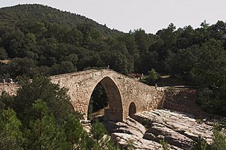
Martorell is a municipality, county, and city that forms part of the Baix Llobregat comarca, in Catalonia, Spain, primarily known for its medieval Devil's bridge. It lies at the confluence of the Llobregat and Anoia rivers.

Sant Andreu de Llavaneres is a municipality located 36 km north of Barcelona (Catalonia) (Spain), along the Mediterranean coast, between Mataró and Sant Vicenç de Montalt. It belongs to the Maresme comarca and the Barcelona province. The short name is simply Llavaneres.

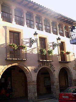
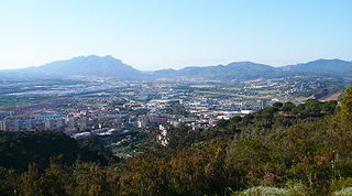
Igualada is a municipality and capital of Anoia county in Penedès, Catalonia, Spain. It is located on the left bank of the Anoia River and at the western end of the Igualada-Martorell-Barcelona Railway. Igualada is the capital and central market of the Anoia comarca, a rich agricultural and wine-producing district. Its population was 38,918 in 2009.

Capellades is a town in Catalonia, Spain, located in the south of the comarca of Anoia, some sixty metres above the Anoia river where it cuts through the Catalan Coastal Range. The C-15 trunk road from Vilafranca del Penedès and the FGC railway line R6 from Martorell and Barcelona run along the river valley below the town on their way to Igualada. It is about one hour from Barcelona by car, bus or train.

Vilafranca del Penedès, or simply Vilafranca, is the capital of Alt Penedès county in Penedès, Catalonia, Spain. It is situated in the Penedès Depression on the left bank of the Foix River, and on the main axis of communication from Barcelona to Tarragona and Valencia, served by a Rodalies Barcelona line 4 and by the AP-7 autopista as well as by the C-243 towards Sant Sadurní d'Anoia, and C-15 roads to Vilanova i la Geltrú and Igualada respectively.

Sant Sadurní d'Anoia is a municipality in the comarca of the Alt Penedès in Catalonia, Spain; and the centre of production of a sparkling wine known as cava. It is situated in the north-east of the Penedès Depression at the confluence of the Avernó river and the Anoia river. It is accessible by the AP-7 autopista and the Renfe railway line (R4) that connect Barcelona with Manresa and El Vendrell.

Calaf is the main town in the northern portion of the comarca of the Anoia in Catalonia, Spain, situated on the Calaf Plain. The town holds an important weekly livestock market.

Vilanova del Camí is a municipality in the comarca of the Anoia in Catalonia, Spain. The name literally means "New Town of the Route", the route being the road from Igualada to Vilafranca del Penedès. It is situated in the centre of the Òdena Basin immediately to the south-east of Igualada. The town is served by a station on the FGC railway line R6 from Barcelona and Martorell to Igualada. There are several sizable industrial parks, serving the entire area.

La Pobla de Claramunt is a municipality in the comarca of the Anoia in Catalonia, Spain. It is situated on the edge of the Òdena Basin at the entrance to the Capellades Gorge. The town is dominated by Claramunt castle, on a hilltop some 150 m above the modern settlement: the castle was, with Castellbell castle, one of the main points of control of access to the Llobregat valley and hence to Barcelona. With neighbouring Capellades, La Pobla de Claramunt is an important centre for paper manufacture. It is served by a station on the FGC railway line R6 from Barcelona and Martorell to Igualada and by the C-244 road from Igualada to Vilafranca del Penedès.

Vallbona d'Anoia is a municipality in the comarca of Anoia in Catalonia, Spain. It is situated to the left of the Anoia river, on the road between Piera and Capellades. The town is served by a station on the FGC railway line R6 from Barcelona and Martorell to Igualada.

Masquefa is a municipality in the comarca of the Anoia in Catalonia, Spain. It is situated on the edge of the Penedès Depression on the road between Piera and Martorell. It is served by a station on the FGC railway line R6 from Barcelona via Martorell to Igualada.

Òdena is a municipality in the comarca of the Anoia in Barcelona province, Catalonia, Spain. It is situated in the centre of the Òdena Basin, on the side of a small hill. The remains of Òdena castle with its octagonal tower are at the top of the hill. The town is served by the C-241 road from Igualada to Manresa, and the main N-II road from Barcelona to Lleida runs through the municipality.
Santa Maragarida de Montbui is a municipality in the comarca of the Anoia in Catalonia, Spain. It is situated in the Òdena Basin, immediately to the west of Igualada of which it effectively forms a suburb. The ajuntament is in Sant Maure. Other neighbourhoods in Montbui are the Old Town, el Saió-Coll del Guix and La Mallola.

Sant Esteve Sesrovires is a municipality in the northern part of the comarca of Baix Llobregat in Catalonia, Spain. It is situated on the left bank of the Anoia river, close to the A-2 highway, and is served by the FGC railway line R6 from Barcelona and Martorell to Igualada.

Maçanet de la Selva is a Spanish municipality in the province of Girona, situated in the comarca of the Selva, Catalonia. It is an important communications junction, where the routes from the coast meet those from the Prelittoral Depression to form a single axis north towards Girona and the French border. RENFE railway lines run both south-east towards Blanes and the coasts of the Maresme and south-west towards Granollers: the station is shared with the neighbouring municipality of Massanes.

Argençola is a municipality in the comarca of the Anoia in Catalonia, Spain. It is situated in the east of the comarca, bordering the Segarra and the Conca de Barberà. The Anoia river has its source on the territory of the municipality. A local road links the municipality with the main N-II road from Barcelona to Lleida.
Cercs is a municipality in the comarca of Berguedà in Catalonia. It is situated on the right bank of the Llobregat river above the Baells reservoir. It is the site of an important power station which burns the lignite extracted at Fígols and Saldes. The town is served by the C-1411 road between Berga and the Cadí tunnel.

La Molsosa is a municipality in the comarca of the Solsonès in Catalonia, Spain. It is situated in the south of the comarca in the Castelltallat range. It is linked to Calaf by a local road. The municipality is split into two parts, the bigger eastern part having nearly all the population. La Molsosa became part of the Solsonès in the comarcal revision of 1990: previously it formed part of the Anoia.

Borredà is a municipality in the comarca of the Berguedà in Catalonia, Spain. It is situated in the upper valley of the Margençol river in the east of the comarca. There are several notable houses from the 17th and 18th centuries. The Romanesque church of Sant Sadurní de Rotgers, a protected historico-artistic monument, can be reached by a mountain track. The village is served by the C-149 road between Berga and Sant Quirze de Besora. The municipality surrounds an exclave of Les Llosses.

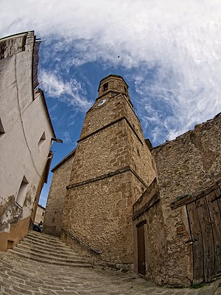
Sant Jaume de Frontanyà is a municipality in the comarca of the Berguedà in Catalonia, Spain. It is situated in the Pyrenees below the peak of Pedró de Tubau (1543 m). The village was the smallest municipality in Catalonia in terms of population but in 2018 lost the title to Gisclareny after the village grew. The monumental Romanesque church of Sant Jaume is a protected historic-artistic monument from the 11th century. The village is served by a local road to Borredà and it is well known for its peace and tranquility.