Talarn is a municipality in the comarca of the Pallars Jussà in Catalonia, Spain. It is situated in the centre of the Tremp basin, on the Noguera Pallaresa river below the Sant Antoni reservoir. It is the site of a hydroelectric power station and of a training school of the Spanish army. The town is served by the C-147 road between Tremp and La Pobla de Segur.

Capellades is a town in Catalonia, Spain, located in the south of the comarca of Anoia, some sixty metres above the Anoia river where it cuts through the Catalan Coastal Range. The C-15 trunk road from Vilafranca del Penedès and the FGC railway line R6 from Martorell and Barcelona run along the river valley below the town on their way to Igualada. It is about one hour from Barcelona by car, bus or train.

Piera is a municipality that covers a large portion of the southeastern corner of the comarca of Anoia in Catalonia, Spain, on the left bank of the Anoia river. The agricultural land, mostly non-irrigated, is used for the cultivation of cereals, grapes, olives and almonds. The town itself hosts a number of light industries: textiles, plastics and construction materials. Tourism during the summer months is also relatively important for the local economy.

Calaf is the main town in the northern portion of the comarca of the Anoia in Catalonia, Spain, situated on the Calaf Plain. The town holds an important weekly livestock market.

Vilanova del Camí is a municipality in the comarca of the Anoia in Catalonia, Spain. The name literally means "New Town of the Route", the route being the road from Igualada to Vilafranca del Penedès. It is situated in the centre of the Òdena Basin immediately to the south-east of Igualada. The town is served by a station on the FGC railway line R6 from Barcelona and Martorell to Igualada. There are several sizable industrial parks, serving the entire area.

Vallbona d'Anoia is a municipality in the comarca of Anoia in Catalonia, Spain. It is situated to the left of the Anoia river, on the road between Piera and Capellades. The town is served by a station on the FGC railway line R6 from Barcelona and Martorell to Igualada.

Masquefa is a municipality in the comarca of the Anoia in Catalonia, Spain. It is situated on the edge of the Penedès Depression on the road between Piera and Martorell. It is served by a station on the FGC railway line R6 from Barcelona via Martorell to Igualada.

Òdena is a municipality in the comarca of the Anoia in Barcelona province, Catalonia, Spain. It is situated in the centre of the Òdena Basin, on the side of a small hill. The remains of Òdena castle with its octagonal tower are at the top of the hill. The town is served by the C-241 road from Igualada to Manresa, and the main N-II road from Barcelona to Lleida runs through the municipality.
Santa Maragarida de Montbui is a municipality in the comarca of the Anoia in Catalonia, Spain. It is situated in the Òdena Basin, immediately to the west of Igualada of which it effectively forms a suburb. The ajuntament is in Sant Maure. Other neighbourhoods in Montbui are the Old Town, el Saió-Coll del Guix and La Mallola.

Castellbell i el Vilar is a municipality in the comarca of the Bages in Catalonia, Spain. It is situated at the point where the Llobregat river crosses the Prelittoral Range. The railway station serves both the FGC line R5 between Barcelona and Manresa and the Renfe line between Barcelona and Zaragoza. The C-1411 road links the municipality with Martorell and Manresa.

Argençola is a municipality in the comarca of the Anoia in Catalonia, Spain. It is situated in the east of the comarca, bordering the Segarra and the Conca de Barberà. The Anoia river has its source on the territory of the municipality. A local road links the municipality with the main N-II road from Barcelona to Lleida.
La Pobla de Lillet is a municipality in the comarca of the Berguedà in Catalonia. It is located in the upper valley of the Llobregat river and is linked to Guardiola de Berguedà by Road B-402.

Castellar de n'Hug is a municipality in the comarca of the Berguedà in Catalonia, Spain. It is situated on the southern slopes of the pyrenean range of the Creueta. The Llobregat river has its source on the territory of the municipality. The village is served by the B-403 road, which links it with La Pobla de Lillet and which continues over the Creueta to the comarques of the Ripollès and the Cerdanya.
Castellet i la Gornal is a municipality in the comarca of the Alt Penedès in Catalonia, Spain. It is situated in the valley of the Foix river at the point where it crosses the Coastal Range. The river is dammed to form the Foix reservoir. The ajuntament is in La Gornal. The municipality is served by the N-340 road, and by a local road to Vilanova i la Geltrú.

Els Guiamets is a municipality in the comarca of the Priorat in Catalonia, Spain. It is situated in the south of the comarca. A local road links the village to the N-420 road between Falset and Móra la Nova. The Guiamets reservoir is on an affluent of the Siurana (Tarragona).
Collsuspina is a municipality in the comarca of Moianès in Catalonia, Spain. Until May 2015 it was part of Osona.

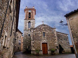
Passanant i Belltall is a municipality in the comarca of the Conca de Barberà in Catalonia, Spain.

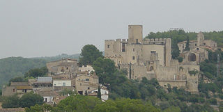
Altafulla is a municipality in the comarca of the Tarragonès in Catalonia, Spain. The town of Altafulla has a beautifully intact old quarter crowned by the Castle of Altafulla, and an old fishing quarter dating back to the 18th century along the beach, called "Baixamar" or "Les Botigues de Mar".

Els Pallaresos is a municipality in the comarca of the Tarragonès in Catalonia, Spain.
Lladurs is a municipality in the comarca of the Solsonès in Catalonia, Spain.