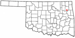
Murphy, Oklahoma

Last updated

Murphy, Oklahoma
CDP
OKMap-doton-Murphy.PNG
Location of Murphy, Oklahoma
Coordinates: 36°7′50″N95°14′51″W / 36.13056°N 95.24750°W / 36.13056; -95.24750
Country United States
State Oklahoma
County Mayes
Area
[1]
  Total4.12 sq mi (10.68 km2)
  Land4.12 sq mi (10.68 km2)
  Water0.00 sq mi (0.00 km2)
Elevation
[2]
794 ft (242 m)
Population
 (2020)
  Total140
  Density33.95/sq mi (13.11/km2)
Time zone UTC-6 (Central (CST))
  Summer (DST) UTC-5 (CDT)
FIPS code 40-49950 [3]
GNIS feature ID2408891 [2]

Murphy is a census-designated place (CDP) in Mayes County, Oklahoma, United States. The population was 231 at the 2000 census.

Contents

Geography

According to the United States Census Bureau, the CDP has a total area of 4.3 square miles (11 km2), all land.

Demographics

Historical population
CensusPop.Note
2020 140
U.S. Decennial Census [4]

As of the census [3] of 2000, there were 231 people, 89 households, and 62 families residing in the CDP. The population density was 53.4 inhabitants per square mile (20.6/km2). There were 110 housing units at an average density of 25.4/sq mi (9.8/km2). The racial makeup of the CDP was 66.23% White, 26.41% Native American, and 7.36% from two or more races. Hispanic or Latino of any race were 0.87% of the population.

There were 89 households, out of which 29.2% had children under the age of 18 living with them, 58.4% were married couples living together, 7.9% had a female householder with no husband present, and 30.3% were non-families. 22.5% of all households were made up of individuals, and 10.1% had someone living alone who was 65 years of age or older. The average household size was 2.60 and the average family size was 3.10.

In the CDP, the population was spread out, with 29.0% under the age of 18, 4.3% from 18 to 24, 28.1% from 25 to 44, 25.1% from 45 to 64, and 13.4% who were 65 years of age or older. The median age was 39 years. For every 100 females, there were 99.1 males. For every 100 females age 18 and over, there were 100.0 males.

The median income for a household in the CDP was $17,330, and the median income for a family was $35,227. Males had a median income of $29,125 versus $12,500 for females. The per capita income for the CDP was $10,472. About 13.5% of families and 22.2% of the population were below the poverty line, including 22.7% of those under the age of eighteen and 26.7% of those 65 or over.

Related Research Articles

<span class="mw-page-title-main">Christie, Oklahoma</span> CDP in Oklahoma, United States

Christie is a census-designated place (CDP) in Adair County, Oklahoma, United States. The population was 218 at the 2010 census, a 31.3 percent increase over the figure of 166 recorded in 2000.

<span class="mw-page-title-main">Welling, Oklahoma</span> Census-designated place in Oklahoma, United States

Welling is an unincorporated community and census-designated place (CDP) in Cherokee County, Oklahoma, United States. The population was 771 at the 2010 census, an increase of 15.25 percent over the figure of 669 recorded in 2000. It is home to The Salvation Army's Heart o' Hills camp and conference center.

Bull Hollow is an unincorporated community and census-designated place (CDP) in Delaware County, Oklahoma, United States. The population was 67 at the 2010 census.

Rocky Ford is a census-designated place (CDP) in Delaware and Cherokee counties, Oklahoma, United States. The population was 61 at the 2010 census.

Sycamore is a census-designated place (CDP) in Delaware County, Oklahoma, United States. The population was 177 at the 2010 census.

<span class="mw-page-title-main">Twin Oaks, Oklahoma</span> Census-designated place in Oklahoma, United States

Twin Oaks is an unincorporated community and census-designated place (CDP) in Delaware County, Oklahoma, United States. The population was 198 at the 2010 census. A tornado hit the town on March 12, 2006, destroying 36 homes and damaging 31 others. 8 people were injured.

<span class="mw-page-title-main">Zena, Oklahoma</span> CDP in Oklahoma, United States

Zena is a census-designated place (CDP) in Delaware County, Oklahoma, United States, along State Highway 127. The population was 122 at the 2010 census. Established on Courthouse Prairie in District 5 of the old Indian Territory, its post office existed from April 11, 1896, until January 31, 1956.

<span class="mw-page-title-main">Cedar Crest, Oklahoma</span> CDP in Oklahoma, United States

Cedar Crest is a census-designated place (CDP) in Mayes County, Oklahoma, United States. The population was 312 at the 2010 census, almost unchanged from the figure of 308 recorded in 2000.

Iron Post is a census-designated place (CDP) in Mayes County, Oklahoma, United States. The population was 117 at the 2000 census, but had declined to 92 in 2010, a loss of more than 21 percent.

<span class="mw-page-title-main">Mazie, Oklahoma</span> CDP in Oklahoma, United States

Mazie is a census-designated place (CDP) in Mayes County, Oklahoma, United States. The population was 91 at the 2010 census.

Sams Corner is a census-designated place (CDP) in Mayes County, Oklahoma, United States. The population was 137 at the 2010 census, compared to 126 at the 2000 census.

<span class="mw-page-title-main">Snake Creek, Oklahoma</span> CDP in Oklahoma, United States

Snake Creek is a census-designated place (CDP) in Mayes County, Oklahoma, United States. The population was 255 at the 2020 census.

<span class="mw-page-title-main">Wickliffe, Oklahoma</span> CDP in Oklahoma, United States

Wickliffe is a census-designated place (CDP) in Mayes County, Oklahoma, United States. The population was 99 at the 2000 census, which declined to 75 in 2010, a drop of 25 percent.

Sour John is a census-designated place (CDP) in Muskogee County, Oklahoma, United States. The population was 61 at the 2000 census.

<span class="mw-page-title-main">Narcissa, Oklahoma</span> CDP in Oklahoma, United States

Narcissa is a census-designated place (CDP) in Ottawa County, Oklahoma, United States. The population was 100 at the 2000 census.

Limestone is a census-designated place (CDP) in Rogers County, Oklahoma, United States, at an elevation of 705 feet. It is located less than 10 miles west of Claremore, Oklahoma on Oklahoma State Highway 20. The population was 753 as of July 2020.

<span class="mw-page-title-main">Sequoyah, Oklahoma</span> CDP in Oklahoma, United States

Sequoyah is a census-designated place (CDP) in Rogers County, Oklahoma, United States. The population was 671 at the 2000 census.

Belfonte is a census-designated place (CDP) in Sequoyah County, Oklahoma, United States. It is part of the Fort Smith, Arkansas-Oklahoma Metropolitan Statistical Area. The population was 426 at the 2000 census.

Stony Point is a census-designated place (CDP) in Sequoyah County, Oklahoma, United States. It is part of the Fort Smith, Arkansas-Oklahoma Metropolitan Statistical Area. The population was 177 at the 2000 census.

<span class="mw-page-title-main">Hebo, Oregon</span> Unincorporated community in the state of Oregon, United States

Hebo is an unincorporated community in Tillamook County, Oregon, United States. For statistical purposes, the United States Census Bureau has defined Hebo as a census-designated place (CDP). The census definition of the area may not precisely correspond to local understanding of the area with the same name. The population of the CDP was 231 at the 2000 census.

References

  1. "ArcGIS REST Services Directory". United States Census Bureau. Retrieved September 20, 2022.
  2. 1 2 U.S. Geological Survey Geographic Names Information System: Murphy, Oklahoma
  3. 1 2 "U.S. Census website". United States Census Bureau . Retrieved January 31, 2008.
  4. "Census of Population and Housing". Census.gov. Retrieved June 4, 2016.