Myrtle Avenue station (BMT Fourth Avenue Line)

Last updated

 Myrtle Avenue
 
Former New York City Subway station
MyrtleAvenueClosing.gif
Notice of the closing of Myrtle Avenue
Station statistics
AddressFlatbush Avenue Extension and Myrtle Avenue
Brooklyn, New York
Borough Brooklyn
Coordinates 40°41′37″N73°59′00″W / 40.6937°N 73.9833°W / 40.6937; -73.9833
Division B (BMT) [1]
Line BMT Fourth Avenue Line
ServicesNone (abandoned)
StructureUnderground
Platforms1 side platform (2 when station was open)
Tracks5 (4 when station was open)
Other information
OpenedJune 22, 1915;110 years ago (1915-06-22) [2]
ClosedJuly 16, 1956;68 years ago (1956-07-16)
Former/other namesGold Street
Station succession
Next north Canal Street (via Broadway Line)
Grand Street (via Sixth Avenue Line)
Chambers Street (via Nassau Loop) (tracks removed)
Next south DeKalb Avenue
Location
NYCS map blank.svg
Map pointer.svg
USA New York City location map.svg
Map pointer.svg
USA New York location map.svg
Map pointer.svg
Track layout

Contents

BSicon MFADEg.svg
BSicon uvSTR.svg
BSicon MFADEg.svg
BSicon uvSTR.svg
BSicon uvSTR.svg
ramps onto
Manhattan Bridge
BSicon uvSTRfg.svg
BSicon uvSTRfg.svg
BSicon uvSTR.svg
BSicon uvSTRc2.svg
BSicon uv-STR.svg
BSicon uvSTR3.svg
BSicon uvSTR.svg
BSicon uvSTR+1.svg
BSicon uvSTRc4.svg
BSicon uv-STR.svg
BSicon udSTR.svg
BSicon uvSHI2l.svg
BSicon ud-KRZ2+4o.svg
BSicon udKRZc3o.svg
BSicon uv-STR.svg
BSicon numN030.svg
BSicon uvKRZc2u.svg
BSicon udKRZc1o.svg
BSicon udSTR3.svg
BSicon udKRZ2+4o-.svg
BSicon udSHI2+r.svg
BSicon udSTR.svg
BSicon udSHI2g+l.svg
BSicon udKRZ3+1u-.svg
BSicon udSTR+c4.svg
BSicon udSHI2g+l.svg
BSicon udSHI2gr+l.svg
BSicon udSHI2r.svg
Myrtle Avenue
BSicon udSTR.svg
BSicon ubvvvSTR.svg
BSicon excPLT.svg
BSicon udSTR.svg
BSicon ubvvvSTR.svg
BSicon excPLT.svg
BSicon udSHI2g+l.svg
BSicon udSHI2lr.svg
BSicon udSHI2g+r.svg
BSicon uvSTR.svg
BSicon MFADEgq.svg
BSicon uvSTRq.svg
BSicon udKRZvo.svg
BSicon ud-STR+r.svg
BSicon ukv-KRZv-2+ro.svg
BSicon ukvKRZ-kvc3o.svg
BSicon uSTR2.svg
BSicon udSTRc3.svg
BSicon uv-2SHI2r.svg
BSicon uvSTR.svg
BSicon ldMKRZ3+1o-.svg
BSicon cMASK.svg
BSicon udSTR.svg
BSicon ukvSTR+4~l.svg
BSicon ucSTRc1.svg
BSicon uSTR+4.svg
BSicon uv2SHI2+l-.svg
BSicon udSTRf.svg
BSicon uvSTR.svg
BSicon udSTRg.svg
BSicon uv-STR.svg
BSicon udSTR.svg
BSicon dPLT.svg
BSicon ubvvvSTR.svg
BSicon dPLT.svg
BSicon udSTR.svg
DeKalb Avenue
BSicon udSTR.svg
BSicon dPLT.svg
BSicon ubvvvSTR.svg
BSicon dPLT.svg
BSicon udSTR.svg
BSicon udSTR.svg
BSicon dPLT.svg
BSicon ubvvvSTR.svg
BSicon dPLT.svg
BSicon udSTR.svg
BSicon udSTR.svg
BSicon dPLT.svg
BSicon ubvvvSTR.svg
BSicon dPLT.svg
BSicon udSTR.svg
BSicon udSTR.svg
BSicon exdPLT.svg
BSicon ubvvvSTR.svg
BSicon exdPLT.svg
BSicon udSTR.svg
BSicon udSHI2gl.svg
BSicon udSHI2+lr.svg
BSicon udSHI2gr.svg
BSicon uvSTR.svg
BSicon udSHI2gl.svg
BSicon udSHI2+lr.svg
BSicon udSHI2gr.svg
BSicon uvSTRf.svg
BSicon udSTR.svg
BSicon uvSTRfg.svg
BSicon udSTR.svg
BSicon uvSTRg.svg
BSicon udSTR.svg
BSicon dMFADEf.svg
BSicon uvSTR.svg
BSicon MFADEf.svg
BSicon uvSTR.svg
BSicon udSTR.svg
BSicon dMFADEf.svg
BSicon uvSTR.svg
BSicon u2SHI6l.svg
BSicon ud2SHI6qc3.svg
BSicon udSTR2.svg
BSicon uSTRc23.svg
BSicon udSTR3.svg
BSicon ud2SHI6qc2.svg
BSicon u2SHI6r.svg
BSicon ud2SHI6qc1.svg
BSicon u2SHI6+r.svg
BSicon ucSTRc1.svg
BSicon udSTR+4.svg
BSicon u2SHI6+l.svg
BSicon udSTR+1.svg
BSicon ucSTRc4.svg
BSicon ud2SHI6qc4.svg
BSicon uvSTRfg.svg
BSicon MFADEf.svg
BSicon uvSTR.svg
Street map

Myrtle Avenue station (BMT Fourth Avenue Line)

The Myrtle Avenue station was a local station on the Manhattan Bridge subway tracks ( B , D , N , and Q trains) in Brooklyn, New York City, at the southern end of the bridge.

History

This station opened on June 22, 1915, along with the rest of the BMT Fourth Avenue Line. [2] The Myrtle Avenue station was sometimes called Gold Street in some early planning documents, [3] and in the Brooklyn Daily Eagle when the station opened. [2]

The city government took over the BMT's operations on June 1, 1940. [4] [5] The station closed on July 16, 1956 for the reconstruction of the flying junction north of DeKalb Avenue to increase capacity for the entire BMT Division. [3] The Brooklyn-bound platform was removed completely, but the Manhattan-bound platform still exists. [6] This station was a casualty of the rebuild. A new track had to be added on the west side to allow for a grade-separated crossing. The original southbound "local" track at the platform had to be depressed to a lower grade to cross under, and the new track wiped out the southbound platform. The northbound platform was left in place but no longer operated for passenger service.

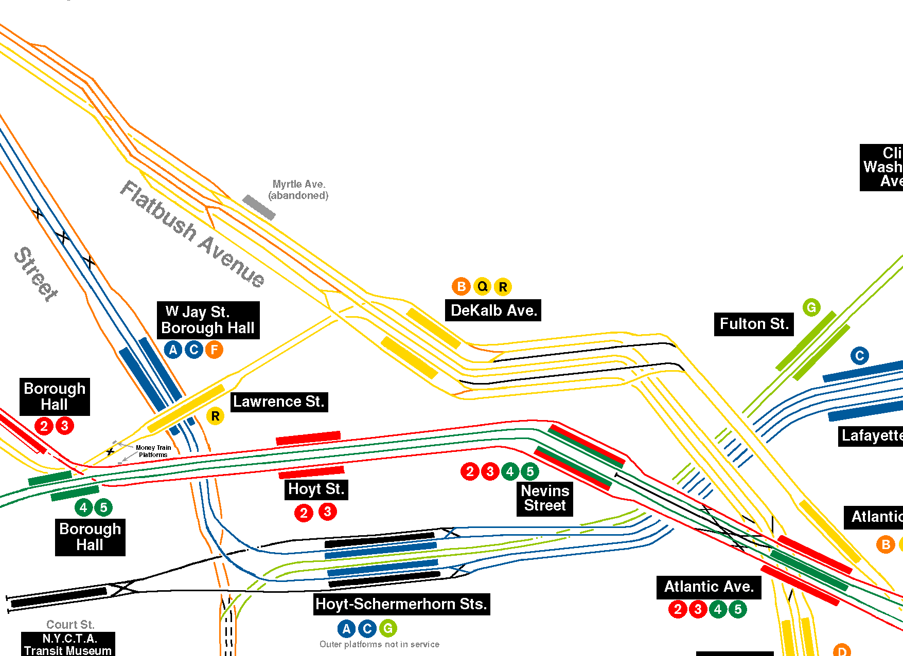
There was a plan to build a loop just north of this station to turn back Fourth Avenue local trains from 95th Street. The bellmouths for the un-built loop can be seen just north of this station where the bypass tracks join the bridge tracks that stop at DeKalb Avenue.

The entrance to the station was from the inside of a building, and after the station was closed up, the connection was blocked off with a cinderblock wall. In 2007, the City allowed a developer that purchased the block above the station to demolish the access point to the station. A thick concrete wall now exists at the entrance to the platform. [7] [8]

Masstransiscope

The Masstransiscope artwork

In 1980 the Masstransiscope zoetrope artwork by Bill Brand was installed in the station. [9] The artwork consists of 228 hand-painted panels that are behind a long slit light box. The artwork stretches for the full 300 feet of the platform. [10] On September 17, 1980, passengers could start seeing the completed work from trains. [11] This allows riders on the Manhattan-bound B and Q trains (and D trains during late nights when they stop at DeKalb Avenue) right before the bridge to look to their right and experience the illusion that the paintings are moving. [12] By the mid-1980s, despite Brand's efforts to maintain the artwork, it fell into a state of disrepair. It was briefly repaired in about 1990, but it was soon covered in graffiti. [13] After falling into a state of disrepair, graffiti was removed in 2008 and the artwork was restored. [14] Masstransiscope was again covered by graffiti during the complete subway shutdown during Hurricane Sandy [15] and again restored after that. [9]

Originally, Brand came up with a more ambitious plan using blown up photographs to create a virtual film strip–these would have been regularly swapped out. [13]

Station layout

Historical track layout
BSicon MFADEg.svg
BSicon uvSTR.svg
BSicon MFADEg.svg
BSicon uvSTR.svg
BSicon uvSTR.svg
ramps onto
Manhattan Bridge
BSicon uvSTRfg.svg
BSicon uvSTRfg.svg
BSicon uvSTR.svg
BSicon uvSTRc2.svg
BSicon uv-STR.svg
BSicon uvSTR3.svg
BSicon uvSTR.svg
BSicon uvSTR+1.svg
BSicon uvSTRc4.svg
BSicon uv-STR.svg
BSicon uvSHI2l.svg
BSicon ud-KRZ2+4o.svg
BSicon udKRZc3o.svg
BSicon uv-STR.svg
BSicon numN030.svg
BSicon uvKRZc1o.svg
BSicon udKRZ2+4o-.svg
BSicon udSHI2+r.svg
BSicon uvSTR-.svg
BSicon uvUST.svg
BSicon udSHI2g+l.svg
BSicon udSHI2gr+l.svg
BSicon uvSHI2r-.svg
Myrtle Avenue
BSicon cPLT.svg
BSicon ubvvvSTR.svg
BSicon cPLT.svg
BSicon cPLT.svg
BSicon ubvvvSTR.svg
BSicon cPLT.svg
BSicon uv-SHI2r.svg
BSicon udSTR.svg
BSicon uvSTR.svg
BSicon MFADEgq.svg
BSicon uvSTRq.svg
BSicon udKRZvo.svg
BSicon ud-STR+r.svg
BSicon ukv-KRZv-2+ro.svg
BSicon ukvKRZ-kvc3o.svg
BSicon uv2SHI2l-.svg
BSicon udSTR.svg
BSicon uvSTR.svg
BSicon ukvSTR+4~l.svg
BSicon ldMKRZ3+1o-.svg
BSicon cMASK.svg
BSicon udSTR.svg
BSicon uv-2SHI2+r.svg
BSicon uSTRc2.svg
BSicon uv-2SHI2r.svg
BSicon uv2SHI2l-.svg
BSicon uABZg3.svg
BSicon uBS2l.svg
BSicon uvSTR.svg
BSicon uABZg2.svg
BSicon uBS2r.svg
BSicon uv-2SHI2r.svg
BSicon uv2SHI2l-.svg
BSicon uSTRc3.svg
BSicon uSTR+1.svg
BSicon uv2SHI2+l-.svg
BSicon uv-2SHI2g+r.svg
BSicon ucdSTRc4.svg
BSicon uvSTR.svg
BSicon uv2SHI2g+l-.svg
BSicon uv-2SHI2+r.svg
BSicon ucSTRc1.svg
BSicon uSTR+4.svg
BSicon udSTR.svg
BSicon dPLT.svg
BSicon udSTRf.svg
BSicon uvSTR.svg
BSicon udSTRg.svg
BSicon dPLT.svg
BSicon udSTR.svg
DeKalb Avenue
BSicon udSTR.svg
BSicon dPLT.svg
BSicon ubvvvSTR.svg
BSicon dPLT.svg
BSicon udSTR.svg
BSicon udSTR.svg
BSicon dPLT.svg
BSicon ubvvvSTR.svg
BSicon dPLT.svg
BSicon udSTR.svg
BSicon udSTR.svg
BSicon dPLT.svg
BSicon ubvvvSTR.svg
BSicon dPLT.svg
BSicon udSTR.svg
BSicon udSTR.svg
BSicon uvSHI2+l.svg
BSicon udSHI2gr.svg
BSicon udSHI2gl.svg
BSicon uvSHI2+r.svg
BSicon udSTR.svg
BSicon uvSTRf.svg
BSicon udSTR.svg
BSicon uvSTRfg.svg
BSicon udSTR.svg
BSicon uvSTRg.svg
BSicon dMFADEf.svg
BSicon udSTR.svg
BSicon uvSTR.svg
BSicon MFADEf.svg
BSicon uvSTR.svg
BSicon uvSTR.svg
BSicon dMFADEf.svg
BSicon udSTR.svg
BSicon uSTR2.svg
BSicon uv2SHI2l-.svg
BSicon ucdSTRc3.svg
BSicon uv-2SHI2r.svg
BSicon ucdSTRc2.svg
BSicon uSTR3.svg
BSicon uSTRc1.svg
BSicon uv-2SHI2+r.svg
BSicon uSTR+4.svg
BSicon uSTR+1.svg
BSicon uv2SHI2+l-.svg
BSicon uSTRc4.svg
BSicon uvSTRfg.svg
BSicon MFADEf.svg
BSicon uvSTR.svg
GStreet Level-
P
Former platform level
Side platform, not in service
Northbound local NYCS-bull-trans-B-Std.svg NYCS-bull-trans-Q-Std.svg ( NYCS-bull-trans-D-Std.svg late nights) do not stop here
(No service: Grand Street (Sixth Avenue) or Canal Street (Broadway))
Northbound express NYCS-bull-trans-D-Std.svg NYCS-bull-trans-N-Std.svg do not stop here
Southbound express NYCS-bull-trans-D-Std.svg does not stop here →
Southbound express NYCS-bull-trans-N-Std.svg does not stop here →
Southbound local NYCS-bull-trans-B-Std.svg NYCS-bull-trans-Q-Std.svg ( NYCS-bull-trans-D-Std.svg late nights) do not stop here →
(No service: DeKalb Avenue)

When open, this underground station had four tracks and two side platforms. The southbound local side platform was demolished to make way for the new fifth track.

References

  1. "Glossary". Second Avenue Subway Supplemental Draft Environmental Impact Statement (SDEIS) (PDF). Vol. 1. Metropolitan Transportation Authority. March 4, 2003. pp. 1–2. Archived from the original (PDF) on February 26, 2021. Retrieved January 1, 2021.
  2. 1 2 3 "Through Tube to Coney, 48 Minutes: First Train on Fourth Avenue Route Beats West End Line Eleven Minutes". Brooklyn Daily Eagle . June 22, 1915. p. 2. Retrieved June 29, 2015.
  3. 1 2 Joseph Brennan (2002). "Abandoned Stations : Myrtle Avenue" . Retrieved September 9, 2010.
  4. "B.M.T. Lines Pass to City Ownership; $175,000,000 Deal Completed at City Hall Ceremony-- Mayor 'Motorman No. 1'". The New York Times. June 2, 1940. ISSN   0362-4331. Archived from the original on July 19, 2021. Retrieved May 14, 2022.
  5. "City Takes Over B. M. T. System; Mayor Skippers Midnight Train". New York Herald Tribune. June 2, 1940. p. 1. ProQuest   1243059209.
  6. "BMT Fourth Avenue Line - Myrtle Avenue". nycsubway.org. Retrieved September 9, 2010.
  7. "Myrtle Ave Abandoned Station and Mezzanine". LTV Squad. September 3, 2005. Retrieved May 7, 2017.
  8. "Myrtle Ave. station lost to time, development". Second Ave. Sagas. March 14, 2007. Retrieved May 7, 2017.
  9. 1 2 mtainfo (August 28, 2013), Reinstalling Masstransiscope, archived from the original on December 15, 2021, retrieved May 7, 2017
  10. "MTA - Arts & Design | NYCT Permanent Art". web.mta.info. Retrieved May 7, 2017.
  11. "Hollywood Under Myrtle Avenue". New York Daily News. September 23, 1980. Retrieved November 5, 2018.
  12. "Jay St./DeKalb Av. track map". nycsubway.org. Retrieved July 8, 2024.
  13. 1 2 Kennedy, Randy (December 31, 2008). "Restored Brooklyn Subway Art Offers Trip to 1970s". The New York Times. ISSN   0362-4331 . Retrieved May 7, 2017.
  14. Bill Brand. "Masstransiscope". Archived from the original on October 5, 2010. Retrieved September 9, 2010.
  15. "The Newly Vandalized Masstransiscope". Archived from the original on October 10, 2016. Retrieved August 29, 2013.