DeKalb Avenue station (BMT lines)

Last updated

 DeKalb Avenue
  NYCS-bull-trans-B-Std.svg NYCS-bull-trans-Q-Std.svg NYCS-bull-trans-R-Std.svg
MTA NYC logo.svg New York City Subway station (rapid transit)
BMT 4th Avenue Dekalb Avenue Southbound Platform.jpg
Southbound platform
Station statistics
AddressDeKalb Avenue & Flatbush Avenue
Brooklyn, NY 11201
Borough Brooklyn
Locale Downtown Brooklyn, Fort Greene
Coordinates 40°41′25″N73°58′56″W / 40.690254°N 73.982277°W / 40.690254; -73.982277
Division B (BMT) [1]
Line BMT Brighton Line
BMT Fourth Avenue Line
Services    B   NYCS-SSI-weekdaysonly.svg (weekdays until 11:00 p.m.)
   D   NYCS-SSI-nightsonly.svg (late nights)
   N   NYCS-SSI-nightsonly.svg (late nights, and limited rush hour service in the reverse-peak direction)
   Q   NYCS-SSI-alltimes.svg (all times)
   R   NYCS-SSI-alltimes.svg (all times)
   W   NYCS-SSI-rushonly.svg (limited rush hour service only)
TransitAiga bus trans.svg NYCT Bus: B25, B26, B38, B52, B54
StructureUnderground
Platforms2 island platforms
cross-platform interchange
Tracks6
Other information
OpenedJune 22, 1915;108 years ago (1915-06-22) [2] (Fourth Avenue)
August 1, 1920;103 years ago (1920-08-01) (Brighton) [3]
Accessible Wheelchair symbol.svg ADA-accessible
Opposite-
direction
transfer
Yes
Traffic
20223,915,266 [4] Increase2.svg 36%
Rank61 out of 423 [4]
Services
Preceding station MTA NYC logo.svg New York City Subway Following station
Grand Street
B   NYCS-SSI-weekdaysonly.svg D   NYCS-SSI-nightsonly.svg
toward 145th Street
NYCS-bull-trans-B-Std.svg Atlantic Avenue–Barclays Center
B   NYCS-SSI-weekdaysonly.svg Q   NYCS-SSI-alltimes.svg
Canal Street
Q   NYCS-SSI-alltimes.svg
toward 96th Street
NYCS-bull-trans-Q-Std.svg
Jay Street–MetroTech
N   NYCS-SSI-nightsonly.svg R   NYCS-SSI-alltimes.svg W   NYCS-SSI-rushonly.svg
NYCS-bull-trans-R-Std.svg
Local
Atlantic Avenue–Barclays Center
D   NYCS-SSI-nightsonly.svg N   NYCS-SSI-nightsonly.svg R   NYCS-SSI-alltimes.svg W   NYCS-SSI-rushonly.svg
Location
NYCS map blank.svg
Map pointer.svg
USA New York City location map.svg
Map pointer.svg
USA New York location map.svg
Map pointer.svg
Track layout

Contents

BSicon MFADEg.svg
BSicon uvSTR.svg
BSicon udSTR.svg
BSicon udSTR.svg
BSicon MFADEg.svg
BSicon uvSTR.svg
BSicon udSTRf.svg
BSicon udSTRg.svg
BSicon udSTRf.svg
BSicon udSTRg.svg
ramps onto
Manhattan Bridge
BSicon uvSTR.svg
BSicon uvSTRc2.svg
BSicon uv-STR.svg
BSicon uvSTR3.svg
BSicon uvSTR.svg
BSicon uvSTR+1.svg
BSicon uvSTRc4.svg
BSicon uv-STR.svg
BSicon udSTR.svg
BSicon udSHI2l.svg
BSicon ud-KRZ2+4o.svg
BSicon udKRZc3o.svg
BSicon uv-STR.svg
BSicon uvSHI2gl-.svg
BSicon udKRZc1o.svg
BSicon udKRZ2+4o-.svg
BSicon udSHI2+r.svg
BSicon udSTR.svg
BSicon udSTRc2.svg
BSicon udSTR.svg
BSicon ud-KRZ3+1u.svg
BSicon udSHI2gr.svg
BSicon udSHI2g+l.svg
BSicon udSHI2gr+l.svg
BSicon udSHI2r.svg
BSicon udABZg+1.svg
BSicon udKRZc4u.svg
BSicon uvSTR.svg
BSicon udSTR.svg
BSicon exdBSr.svg
Myrtle Avenue
BSicon udSTR.svg
BSicon uvSTR.svg
BSicon uvSTR.svg
BSicon exdBSr.svg
BSicon udSHI2g+l.svg
BSicon udSHI2lr.svg
BSicon udSHI2g+r.svg
BSicon udSTR.svg
BSicon udSTR.svg
BSicon MFADEgq.svg
BSicon uvSTRq.svg
BSicon udKRZvo.svg
BSicon ud-STR+r.svg
BSicon ukv-KRZv-2+ro.svg
BSicon ukvKRZ-kvc3o.svg
BSicon uSTR2.svg
BSicon udSTRc3.svg
BSicon uv-2SHI2r.svg
BSicon udSTR.svg
BSicon udSTR.svg
BSicon ldMKRZc1o.svg
BSicon udSTR.svg
BSicon ukvSTR+4~l.svg
BSicon ucSTRc1.svg
BSicon uSTR+4.svg
BSicon uv2SHI2+l-.svg
BSicon uvSTR.svg
BSicon uvSTR.svg
BSicon uv-STR.svg
BSicon udSTR.svg
BSicon dBS.svg
BSicon uvSTR.svg
BSicon uvSTR.svg
BSicon dBS.svg
BSicon udSTR.svg
BSicon udSTR.svg
BSicon dBS.svg
BSicon uvSTR.svg
BSicon uvSTR.svg
BSicon dBS.svg
BSicon udSTR.svg
DeKalb Avenue
BSicon udSTR.svg
BSicon dBS.svg
BSicon uvSTR.svg
BSicon uvSTR.svg
BSicon dBS.svg
BSicon udSTR.svg
BSicon udSTR.svg
BSicon dBS.svg
BSicon uvSTR.svg
BSicon uvSTR.svg
BSicon dBS.svg
BSicon udSTR.svg
BSicon udSHI2gl.svg
BSicon udSHI2+lr.svg
BSicon udSHI2gr.svg
BSicon uvSTR.svg
BSicon udSHI2gl.svg
BSicon udSHI2+lr.svg
BSicon udSHI2gr.svg
BSicon uvSTRf.svg
BSicon udSTR.svg
BSicon uvSTRfg.svg
BSicon udSTR.svg
BSicon uvSTRg.svg
BSicon udSTR.svg
BSicon dMFADEf.svg
BSicon udSTR.svg
BSicon udSTR.svg
BSicon MFADEf.svg
BSicon uvSTR.svg
BSicon udSTR.svg
BSicon dMFADEf.svg
BSicon udSTR.svg
BSicon udSTR.svg
BSicon uSTR2.svg
BSicon uSTR.svg
BSicon uSTRc3.svg
BSicon uSTRc2.svg
BSicon uSTR.svg
BSicon uSTR3.svg
BSicon uSTRc1.svg
BSicon uBS2l.svg
BSicon uSTR2h+4.svg
BSicon udBS2c3.svg
BSicon udBS2c2.svg
BSicon uSTR3h+1.svg
BSicon uBS2r.svg
BSicon udSTRc4.svg
BSicon uvSTRfg.svg
BSicon numN045.svg
BSicon dMFADEf.svg
BSicon udSTR.svg
BSicon dMFADEf.svg
BSicon udSTR.svg
Street map

DeKalb Avenue station (BMT lines)

Station service legend
SymbolDescription
NYCS-SSI-allexceptnights.svg Stops all times except late nights
NYCS-SSI-alltimes.svg Stops all times
NYCS-SSI-weekdaysonly.svg Stops weekdays during the day
NYCS-SSI-nightsonly.svg Stops late nights only
NYCS-SSI-rushonly.svg Stops rush hours only
NYCS-SSI-rushpeak.svg Stops rush hours in the peak direction only

The DeKalb Avenue station is an interchange station on the BMT Brighton Line and BMT Fourth Avenue Line of the New York City Subway, located at the intersection of DeKalb and Flatbush Avenues in Downtown Brooklyn. It is served by the Q and R trains at all times, the B train on weekdays, and the D and N trains during late nights. During rush hours only, a few W train trips also serve this station.

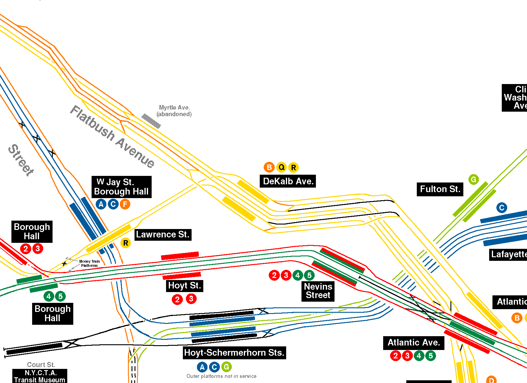
The station has six tracks and two island platforms. The two innermost tracks are used by Fourth Avenue express trains, which skip the station, while the four outer tracks are used by Brighton Line and Fourth Avenue local trains. The track configuration has been arranged several times. The current configuration dates from a 1956–1961 reconstruction project to straighten the platforms and eliminate a level junction north of the station, which had caused a switching bottleneck. Other plans, such as connections to the BMT Fulton Street Line and IRT Eastern Parkway Line, were considered at times.

History

Construction and opening

The New York City Board of Estimate approved the construction of the Fourth Avenue Line, a subway line running under Fourth Avenue, in early 1908. The line would run over the Manhattan Bridge to Manhattan at its northern end. [5] [6] Contracts for the Fourth Avenue Line were awarded on May 22, 1908, for the section between 43rd Street and the Manhattan Bridge, but the Board of Estimate did not approve them until October 29, 1909, when a taxpayer's lawsuit regarding the city's debt was settled. [6] Groundbreaking for the first section of the subway, between DeKalb Avenue and 43rd Street (ending at 36th Street), took place on November 13, 1909, at DeKalb Avenue and Flatbush Avenue, after the plans and surveys for the line were completed. [7] [8] The Fourth Avenue Line was assigned to the BRT (after 1923, the Brooklyn–Manhattan Transit Corporation or BMT [9] ) in the Dual Contracts, adopted on March 4, 1913. [10] :203–219 [11] [12] William Bradley built the portion of the line from the intersection of Flatbush Avenue Extension and Willoughby Street to the intersection of Fulton Street and Ashland Place, including the DeKalb Avenue station. [13]

The DeKalb Avenue station was originally intended only as a local station on the Fourth Avenue Line. After the Montague Street Tunnel was approved, [14] the planned station was changed to an express station that could serve trains from both the Manhattan Bridge and the Montague Street Tunnel (there would still be two bypass tracks for Fourth Avenue express trains using the bridge). [8] [15] In November 1914, the New York Public Service Commission began requesting bids for the installation of station finishes at the DeKalb Avenue station. [14] [16] The commission also requested bids for the addition of crossovers, allowing trains from the tunnel or the bridge to stop at DeKalb Avenue. [14] The Public Service Commission awarded the contract for the modifications to Samuel Beskin. [17] To accommodate these crossovers, contractors had to cut into partition walls that had already been built. [15]

The DeKalb Avenue station opened on June 22, 1915, as part of an extension of the subway to Coney Island, which included the Fourth Avenue Line north of 59th Street as well as the entire Sea Beach Line. [18] [2] The station's opening was marked with a competition between two trains heading from Chambers Street station in Manhattan to the Coney Island station, one heading via the West End Line and the other via the Sea Beach Line; the latter got to Coney Island first. [2] As a local station, the DeKalb Avenue station was originally 435 feet (133 m) long. [19] :24 [20] :854

Also as part of the Dual Contracts, an extension of the Brighton Line was approved. [21] The extension was to run under St. Felix Street in Downtown Brooklyn, splitting off the Fourth Avenue Line south of the DeKalb Avenue station. It would then run under Flatbush Avenue south of Atlantic Avenue, sharing a tunnel with the Interborough Rapid Transit Company (IRT)'s Eastern Parkway Line. [22] [23] The Brighton Line extension opened on August 1, 1920, [24] serving the DeKalb Avenue station with the Fourth Avenue Line and providing direct service between the existing Brighton Line and Midtown Manhattan. [3] Afterward, the DeKalb Avenue station was referred to as "the heart of the BMT", as it is a major transfer point between BMT services with lines splitting north and south of the station. [25]

1920s to 1950s

HEET turnstiles DeKalb Avenue's HEET Turnstiles.jpg
HEET turnstiles

In 1922, the New York State Transit Commission directed its engineers to prepare plans for lengthening the platforms at 23 stations on the BMT's lines to accommodate eight-car trains. As part of the project, platforms would be lengthened to 530 feet (160 m). [26] [27] Though the Transit Commission ordered the BMT to lengthen these platforms in September 1923, [28] no further progress was made until February 16, 1925, when the New York City Board of Transportation (BOT) commissioned its engineers to examine platform-lengthening plans for DeKalb Avenue and eleven other stations along the Fourth Avenue Line. It estimated the project would cost $633,000 (equivalent to $10,563,000in 2022). [29] The New York City Board of Estimate appropriated $362,841 for the lengthening of the platforms at DeKalb Avenue and five other stations in January 1926 [30] [31] and awarded the contract to Charles Meads & Company early the next month. [32] [33] As part of the project, the original signal tower at the end of the platform was demolished to make way for the platform extension, and a new signal tower was built to control traffic on the Manhattan Bridge and Montague Street Tunnel. [34] The platform extension at DeKalb Avenue opened on August 1, 1927. [35] [34]

The Dime Savings Bank, which had its headquarters at 9 DeKalb Avenue just above the station, opened a branch on the station's mezzanine level in August 1956. [36] The opening of the bank branch followed several months of negotiations. The bank had wanted to open a corridor from the station directly into its building, but this was not possible because of the presence of various underground conduits, pipes, and emergency exits, so the bank decided instead to rent space in the station. [37]

Track reconfiguration

The station has been reconfigured a number of times. Originally, the extreme outside tracks in each direction hosted the Fourth Avenue Line local tracks and the next pair hosted the Brighton Line. The middle tracks, which bypassed the station, hosted the Fourth Avenue express tracks. A group of level crossovers at the northern end of the station allowed all tracks access to both sides of the Manhattan Bridge and to the Montague Street Tunnel. The Fourth Avenue local tracks led straight onto the Manhattan Bridge west of the station, while the Brighton line tracks led straight to the Montague Street Tunnel, so the crossovers allowed trains from both lines to switch between the bridge and the tunnel. [38]

The city government took over the BMT's operations on June 1, 1940. [39] [40] By then, the original track layout caused many train delays on the Fourth Avenue and Brighton lines. In 1952, the junction was earmarked for "top priority" reconstruction. [41] On November 30, 1955, the New York City Transit Authority sent a recommendation to the Board of Estimate for the approval of a $13,152,831 contract to eliminate the bottleneck. [42] The elimination of the bottleneck was the first step in a larger plan to improve transit service between Brooklyn and Manhattan. [42] [43] The Citizens Budget Commission recommended that the appropriation be canceled, but three other civic groups opposed the elimination of the funding. [44]

Myrtle Avenue closing notice MyrtleAvenueClosing.gif
Myrtle Avenue closing notice

During the reconstruction of the junction that started in 1956 and was completed by April 1961, the Brighton Line tracks were connected to the DeKalb Avenue station's outermost tracks. A diamond crossover north of the station had caused frequent bottlenecks, but was removed during the realignment and replaced with two flying junctions. [45] All switches immediately north of the station were eliminated. The junction towards the Manhattan Bridge was rebuilt. To make room for a new flying junction, the Myrtle Avenue station was closed. That station's northbound platform remains visible from passing trains, but the southbound platform was demolished to accommodate the new flying junction that replaced the diamond crossover. Platforms were also doubled in length to accommodate ten-car trains of 60-foot-long (18 m) cars. [46] It was estimated that the reconstruction of the junction increased the junction's train capacity by 25%. [41]

The Chrystie Street Connection project was also tied to this improvement, as it resulted in more trains using the bridge, as well as connecting trains to the Independent Subway System (IND)'s Sixth Avenue Line (and thus, to IND lines to the Bronx and Queens). [41] [47] Over the years, as more of the business community migrated to Midtown Manhattan, the slower tunnel route via Lower Manhattan became less popular. When the Chrystie Street Connection opened in 1967, the station became a transfer point for trains to and from the IND Sixth Avenue Line. [48]

Station overhauls

Station name mosaic DeKalb Avenue station mosaic.jpg
Station name mosaic

After the 1961 reconstruction, some adjustments were made to the station. The original platform extensions were closed and replaced by straight extensions to the north in 1960. The abandoned portions can be seen from the open platforms and trains. In the mid-1960s, the station platforms were extended northward at least 150 feet (46 m) to accommodate for a 600 feet (180 m) train. It also added new '60s modern look tiling.

The Metropolitan Transportation Authority (MTA) announced in late 1978 that it would modernize the DeKalb Avenue station. The improvements included new finishes on the walls and floors; acoustical, signage, and lighting improvements; replacement of old mechanical equipment; and new handrails. [49] In spite of the renovation, the MTA listed the station among the 69 most deteriorated stations in the subway system in 1981. [50]

In the early 2000s, architect Lee Harris Pomeroy designed a renovation of the DeKalb Avenue station. The plans included adding elevators for ADA accessibility, as well as restoring the original station tiles and mosaics. [51] The latest major overhaul was in 2004–2006. The station was repaired and became an ADA-accessible station. The MTA repaired the staircases, retiled the walls, added new tiles to the floors, upgraded the station's lights and public address system, installed ADA yellow safety treads along the platform edge and replaced the trackbeds for all trains entering or bypassing the station. It also installed elevators on both platforms, as well as elevators to the street level. [52]

Station layout

GroundStreet levelExit/entrance
MezzanineFare control, station agent, MetroCard machines
Wheelchair symbol.svg Elevator at southeast corner of DeKalb Avenue and Flatbush Avenue Ext
Platform levelNorthbound local via Bridge NYCS-bull-trans-B-Std.svg weekdays toward Bedford Park Boulevard or 145th Street (Grand Street)
NYCS-bull-trans-Q-Std.svg toward 96th Street (Canal Street)
NYCS-bull-trans-D-Std.svg toward Norwood–205th Street late nights (Grand Street)
NYCS-bull-trans-N-Std.svg toward Astoria–Ditmars Boulevard (select weekday trips) (Canal Street)
(No service: Myrtle Avenue)
Island platform Wheelchair symbol.svg
Northbound local via Tunnel NYCS-bull-trans-R-Std.svg toward Forest Hills–71st Avenue (Whitehall Street–South Ferry late nights) (Jay Street–MetroTech)
NYCS-bull-trans-N-Std.svg toward Astoria–Ditmars Boulevard late nights (Jay Street–MetroTech)
NYCS-bull-trans-W-Std.svg toward Astoria–Ditmars Boulevard (select weekday trips) (Jay Street–MetroTech)
Northbound express via Bridge NYCS-bull-trans-D-Std.svg NYCS-bull-trans-N-Std.svg do not stop here
Southbound express via Bridge NYCS-bull-trans-D-Std.svg NYCS-bull-trans-N-Std.svg do not stop here →
Southbound local via Tunnel NYCS-bull-trans-R-Std.svg toward Bay Ridge–95th Street (Atlantic Avenue–Barclays Center/Fourth)
NYCS-bull-trans-N-Std.svg toward Coney Island–Stillwell Avenue via Sea Beach late nights (Atlantic Avenue–Barclays Center/Fourth)
NYCS-bull-trans-W-Std.svg toward 86th Street (select weekday trips) (Atlantic Avenue–Barclays Center/Fourth)
Island platform Wheelchair symbol.svg
Southbound local via Bridge NYCS-bull-trans-B-Std.svg weekdays toward Brighton Beach (Atlantic Avenue–Barclays Center/Brighton)
NYCS-bull-trans-Q-Std.svg toward Coney Island–Stillwell Avenue via Brighton (Atlantic Avenue–Barclays Center/Brighton)
NYCS-bull-trans-D-Std.svg toward Coney Island–Stillwell Avenue via West End late nights (Atlantic Avenue–Barclays Center/Fourth)
NYCS-bull-trans-N-Std.svg toward Coney Island–Stillwell Avenue via Sea Beach (select weekday trips) (Atlantic Avenue–Barclays Center/Fourth)

This underground station has six tracks with island platforms between the two outer pairs of tracks, while the two center tracks bypass the station. B trains stop here on weekdays only except nights, Q and R trains stop here at all times, and D and N trains stop here during nights as well as northbound on weekdays after 6:45 p.m. The platform columns are painted red on their lower halves and cream on their upper halves.[ citation needed ] The next station to the north is Jay Street–MetroTech for Montague Street Tunnel R and late night N trains, Canal Street for N and Q trains using the southern tracks of the Manhattan Bridge, and Grand Street for BandD trains using the northern tracks of the Manhattan Bridge. The next station to the south is Atlantic Avenue–Barclays Center on the Fourth Avenue Line for D, N, and R trains and Atlantic Avenue–Barclays Center on the Brighton Line for B and Q trains, [53] although they are different platforms and formerly different stations.

Exits

Street stair DeKalb Avenue-Fleet Street Entrance.JPG
Street stair
Elevator and stair outside the now-closed Applebee's restaurant DeKalb Avenue; BMT 4th Applebee's Entrance-1.jpg
Elevator and stair outside the now-closed Applebee's restaurant

This station has two entrances/exits, each with access to either the east or west side of Flatbush Avenue. The staffed exit is near the south end and has two staircases and one elevator from each platform that go up to a waiting area above the platforms and tracks that contains two restrooms open from 5:00 a.m. to midnight. Outside of the turnstile bank is a token booth, a single street stair to the southwest corner of DeKalb Avenue and the Flatbush Avenue Extension built inside a store front, and two staircases that meet at their landings and an elevator that go up to the southeast corner outside a former Applebee's restaurant. [54] [55] The centers of the platforms have a crossover that connects them both. Both the crossover and the staffed exit were part of a wide mezzanine area, but most of the mezzanine was closed off and converted to crew rooms.

The other entrance/exit is at the station's extreme north end and is unstaffed. An up-only escalator and long staircase from each platform goes up to a mezzanine above the tracks. Two pairs of exit-only turnstiles and one set of four turnstiles provide entrance/exit from the system. This entrance has two street stairs: one to Fleet Street on the east side, outside Long Island University Brooklyn, and the other to the former Albee Square on the west side, outside the City Point development. [54]

Detail of DeKalb Improvisation artwork DeKalb Avenue art vc.jpg
Detail of DeKalb Improvisation artwork

Both fare control areas feature a 2005 artwork called DeKalb Improvisation by Stephen Johnson. It consists of a large mural in the main fare control area and several smaller ones in the secondary one.

Track layout

North of the station, the outer and bypass tracks head towards the Manhattan Bridge to Manhattan with a flying junction. B and D trains use the north side of the bridge via the Chrystie Street Connection to the IND Sixth Avenue Line. N and Q trains use the south side of the bridge to the BMT Broadway Line. [45] Trains traveling through this interlocking are frequently delayed, since Brighton and Fourth Avenue trains have to cross over each other to use both the Broadway and Sixth Avenue Lines. [56] R trains and late night N trains continue on the middle tracks north along the BMT Fourth Avenue Line into the Montague Street Tunnel towards the BMT Broadway Line.

South of the station, the bypass tracks become the express tracks on the Fourth Avenue Line. The four remaining tracks become six tracks at a flying junction. [45] Trains headed south on the tunnel local tracks or outer tracks proceed to the BMT Brighton Line or switch from those two tracks and provide the route to the Fourth Avenue Line local tracks. In the current service pattern, the tunnel route is not used for Brighton Line trains. [45] Also south of this station, there is a bellmouth where the northbound track of the Brighton Line curves northwest onto Fulton Street. The bellmouth marks the location where the westbound track of the proposed Ashland Place Connection, which would have connected to the now-demolished BMT Fulton Street El, would have merged with the Brighton Line. [57] [58] The eastbound track of the Ashland Place Connection was not built. The track would have diverged from the southbound Brighton Line between Ashland Place and St. Felix Street, then curved east under Lafayette Avenue, to avoid an at-grade junction with the Brighton Line. [58]

The DeKalb Avenue station was also built with provisions for a possible track connection to Nevins Street station. The station has a shortened mezzanine because room was needed for a proposed Lafayette Avenue line. The subway connection was never built. North of this station, near the Manhattan Bridge, there is a provision for a never-built loop back to southern Brooklyn without crossing the Manhattan Bridge into Manhattan. Bellmouths for the unbuilt loop are visible from passing trains. South of this station, a junction was built at Fulton Street for a never-built branch to run via Lafayette Avenue and Broadway. [45]

Service patterns

Jay Street–MetroTech
(BMT Fourth Avenue Line)
Canal Street
(BMT Broadway Line)
Grand Street
(IND Sixth Avenue Line)
North-west of the station
BMT Fourth Avenue Line local
   N   NYCS-SSI-nightsonly.svg (late nights)
   R   NYCS-SSI-alltimes.svg (all times)
   W   NYCS-SSI-rushonly.svg (limited rush hour service only)
BMT Broadway Line
   N   NYCS-SSI-allexceptnights.svg (all except late nights)
   Q   NYCS-SSI-alltimes.svg (all times)
IND Sixth Avenue Line express
   B   NYCS-SSI-weekdaysonly.svg (weekdays until 11:00 p.m.)
   D   NYCS-SSI-alltimes.svg (all times)
tunnel tracks Manhattan Bridge south Manhattan Bridge north
In the station
inner platform tracks (tunnel)
   N   NYCS-SSI-nightsonly.svg (late nights)
   R   NYCS-SSI-alltimes.svg (all times)
   W   NYCS-SSI-rushonly.svg (limited rush hour service only)
center tracks (bridge, bypass)
   D   NYCS-SSI-allexceptnights.svg (all except late nights)
   N   NYCS-SSI-allexceptnights.svg (all except late nights)
outermost tracks (bridge)
   B   NYCS-SSI-weekdaysonly.svg (weekdays until 11:00 p.m.)
   D   NYCS-SSI-nightsonly.svg (late nights)
   Q   NYCS-SSI-alltimes.svg (all times)
South of the station
BMT Fourth Avenue Line local
   D   NYCS-SSI-nightsonly.svg (late nights)
   N   NYCS-SSI-nightsonly.svg (late nights)
   R   NYCS-SSI-alltimes.svg (all times)
   W   NYCS-SSI-rushonly.svg (limited rush hour service only)
BMT Fourth Avenue Line express
   D   NYCS-SSI-allexceptnights.svg (all except late nights)
   N   NYCS-SSI-allexceptnights.svg (all except late nights)
BMT Brighton Line
   B   NYCS-SSI-weekdaysonly.svg (weekday rush hours, middays and early evenings)
   Q   NYCS-SSI-alltimes.svg (all times)
Atlantic Avenue–Barclays Center
(BMT Fourth Avenue Line)
Atlantic Avenue–Barclays Center
(BMT Brighton Line)

Related Research Articles

<span class="mw-page-title-main">Q (New York City Subway service)</span> New York City Subway service

The Q Second Avenue/Broadway Express/Brighton Local is a rapid transit service in the B Division of the New York City Subway. Its route emblem, or "bullet", is colored yellow since it is a part of the BMT Broadway Line in Manhattan.

The BMT Brighton Line, also known as the Brighton Beach Line, is a rapid transit line in the B Division of the New York City Subway in Brooklyn, New York City, United States. Local service is provided at all times by the Q train, but is joined by the B express train on weekdays. The Q train runs the length of the entire line from Coney Island–Stillwell Avenue to the Manhattan Bridge south tracks. The B begins at Brighton Beach and runs via the bridge's north tracks.

<span class="mw-page-title-main">Proposed expansion of the New York City Subway</span>

Since the opening of the original New York City Subway line in 1904, and throughout the subway's history, various official and planning agencies have proposed numerous extensions to the subway system. The first major expansion of the subway system was the Dual Contracts, a set of agreements between the City of New York and the IRT and the BRT. The system was expanded into the outer reaches of the Bronx, Brooklyn, and Queens, and it provided for the construction of important lines in Manhattan. This one expansion of the system provided for a majority of today's system.

<span class="mw-page-title-main">Nevins Street station</span> New York City Subway station in Brooklyn

The Nevins Street station is an express station on the IRT Eastern Parkway Line of the New York City Subway. Located at the intersection of Nevins Street, Flatbush Avenue, and Fulton Street in Downtown Brooklyn, it is served by the 2 and 4 trains at all times, the 3 train all times except late nights, and the 5 train on weekdays only.

<span class="mw-page-title-main">Chrystie Street Connection</span> New York City Subway track connections

The Chrystie Street Connection is a set of New York City Subway tunnels running the length of Chrystie Street on the Lower East Side of Manhattan. It is one of the few track connections between lines of the former Brooklyn–Manhattan Transit Corporation (BMT) and Independent Subway System (IND) divisions, which together constitute the system's B Division. A major branch of the IND Sixth Avenue Line, it connects the Sixth Avenue Line to the BMT Brighton Line and BMT Fourth Avenue Line via the north side of the Manhattan Bridge and to the BMT Jamaica Line over the Williamsburg Bridge. The project, opened in 1967 and 1968, also includes the Sixth Avenue Line's Grand Street and 57th Street stations, the latter of which is not part of the connection itself.

The Nassau Street Loop, also called the Nassau Loop, was a service pattern of the Brooklyn–Manhattan Transit Corporation (BMT) inaugurated in 1931 when the BMT Nassau Street Line was completed, providing a physical link that allowed a train to originate in Brooklyn, run through Lower Manhattan and return to Brooklyn without having to terminate and reverse the direction of the train. Nassau Loop services have not been able to operate since 1967, when the Loop line's connection to the Manhattan Bridge was severed.

The BMT Nassau Street Line is a rapid transit line of the B Division of the New York City Subway system in Manhattan. At its northern end, the line is a westward continuation of the BMT Jamaica Line in Brooklyn after the Jamaica Line crosses the Williamsburg Bridge into Manhattan. The Nassau Street Line continues south to a junction with the BMT Broadway Line just before the Montague Street Tunnel, after which the line reenters Brooklyn. Although the tracks merge into the Broadway Line south of Broad Street, there has been no regular service south of the Broad Street station since June 25, 2010. While the line is officially recognized as the Nassau Street Line, it only serves one station on Nassau Street: Fulton Street.

<span class="mw-page-title-main">M (New York City Subway service)</span> New York City Subway service

The M Sixth Avenue Local is a rapid transit service in the B Division of the New York City Subway. Its route emblem, or "bullet", is colored orange since it uses the IND Sixth Avenue Line in Manhattan.

<span class="mw-page-title-main">N (New York City Subway service)</span> New York City Subway service

The N Broadway Express is a rapid transit service in the B Division of the New York City Subway. Its route emblem, or "bullet," is colored yellow, since it uses the BMT Broadway Line in Manhattan.

The BMT Sea Beach Line is a rapid transit line of the BMT division of the New York City Subway, connecting the BMT Fourth Avenue Line at 59th Street via a four-track wide open cut to Coney Island in Brooklyn. It has at times hosted the fastest express service between Manhattan and Coney Island, since there are no express stations along the entire stretch, but now carries only local trains on the N service, which serves the entire line at all times. During rush hours, several W trains serve the line north of 86th Street.

The BMT Fourth Avenue Line is a rapid transit line of the New York City Subway, mainly running under Fourth Avenue in Brooklyn. The line is served by the D, N, and R at all times; the R typically runs local, while the D and N run express during the day and local at night. During rush hours, select W trains also serve the line. Northbound D and N trains run local along the line after 6:45 p.m. during weekdays as well. The line was originally built by the Brooklyn Rapid Transit Company and is now internally operated as part of the New York City Subway's B Division.

<span class="mw-page-title-main">Prospect Park station (BMT lines)</span> New York City Subway station in Brooklyn

The Prospect Park station is an express station on the BMT Brighton Line of the New York City Subway. It is located in between Lincoln Road, Lefferts Avenue, Empire Boulevard, Ocean Avenue and Flatbush Avenue in Flatbush, Brooklyn, near the border of Crown Heights, Prospect Heights, Park Slope, and Prospect Lefferts Gardens. The station, which serves Prospect Park and Brooklyn Botanic Garden, is served by the Q train and Franklin Avenue Shuttle at all times and by the B train on weekdays.

<span class="mw-page-title-main">Seventh Avenue station (BMT Brighton Line)</span> New York City Subway station in Brooklyn

The Seventh Avenue station is a station on the BMT Brighton Line of the New York City Subway, located at the intersection of Seventh Avenue, Park Place and Flatbush Avenue in Park Slope and Prospect Heights, Brooklyn. The station is served by the Q train at all times and by the B train on weekdays only.

<span class="mw-page-title-main">Avenue H station</span> New York City Subway station in Brooklyn

The Avenue H station is a local station on the BMT Brighton Line of the New York City Subway. It is located at Avenue H between East 15th and East 16th Streets near the border of Midwood and Flatbush, Brooklyn. The station is served by the Q train at all times.

<span class="mw-page-title-main">Church Avenue station (BMT Brighton Line)</span> New York City Subway station in Brooklyn

The Church Avenue station is an express station on the BMT Brighton Line of the New York City Subway, located at Church Avenue near East 18th Street in the Flatbush neighborhood of Brooklyn. The station is served by the Q train at all times and by the B train on weekdays only.

<span class="mw-page-title-main">Parkside Avenue station</span> New York City Subway station in Brooklyn

The Parkside Avenue station is a local station on the BMT Brighton Line of the New York City Subway. It is located at Parkside Avenue and Ocean Avenue in Flatbush, Brooklyn. The station is served by the Q train at all times.

<span class="mw-page-title-main">Atlantic Avenue–Barclays Center station</span> New York City Subway station complex in Brooklyn

The Atlantic Avenue–Barclays Center station is a New York City Subway station complex shared by the BMT Fourth Avenue Line, the BMT Brighton Line and the IRT Eastern Parkway Line. Named after Atlantic Avenue and the Barclays Center arena, it is located at Fourth and Flatbush Avenues' intersections with Atlantic Avenue and Pacific Street in Downtown Brooklyn. The complex is served by the 2, 4, D, N, Q and R trains at all times; the 3 train at all times except late nights; the 5 and B trains on weekdays during the day; and a few rush-hour W trains.

The IRT Eastern Parkway Line is one of the lines of the A Division of the New York City Subway. Built for the Interborough Rapid Transit Company (IRT), it stretches from Downtown Brooklyn south along Flatbush Avenue and east along Eastern Parkway to Crown Heights. After passing Utica Avenue, the line rises onto an elevated structure and becomes the New Lots Line to the end at New Lots Avenue in East New York, Brooklyn. The west end of the Eastern Parkway Line is at the Joralemon Street Tunnel under the East River.

References

  1. "Glossary". Second Avenue Subway Supplemental Draft Environmental Impact Statement (SDEIS) (PDF). Vol. 1. Metropolitan Transportation Authority. March 4, 2003. pp. 1–2. Archived from the original (PDF) on February 26, 2021. Retrieved January 1, 2021.
  2. 1 2 3 "Through Tube to Coney, 48 Minutes: First Train on Fourth Avenue Route Beats West End Line Eleven Minutes". Brooklyn Daily Eagle. June 22, 1915. Retrieved June 29, 2015 via newspapers.com.
  3. 1 2 "New Subways Add Seven More Miles to BRT on Aug 1". Brooklyn Daily Eagle . July 25, 1920. Archived from the original on October 26, 2016. Retrieved August 19, 2016 via newspapers.com.
  4. 1 2 "Annual Subway Ridership (2017–2022)". Metropolitan Transportation Authority. 2022. Retrieved November 8, 2023.
  5. "Building of Fourth Ave. Subway Crowns Decade of Civic Struggle". The Brooklyn Daily Eagle. June 21, 1911. p. 10. Retrieved May 4, 2017 via newspapers.com.
  6. 1 2 Fourth Avenue Subway, Brooklyn's New Transportation Line: A Part of the Dual System of Rapid Transit of the City of New York. New York State Public Service Commission. June 19, 1915.
  7. "Fourth Ave. Subway Dirt Begins to Fly" (PDF). The New York Times. November 14, 1909. Archived (PDF) from the original on August 10, 2021. Retrieved June 28, 2015.
  8. 1 2 "Opening of Fourth Avenue Subway Marks Climax of Eleven Years' Work". The Brooklyn Daily Eagle. June 19, 1915. p. 24. Retrieved May 27, 2023.
  9. State of New York Transit Commission Third Annual Report for the Calendar Year 1923. New York State Transit Commission. 1924. p. 501.
  10. Walker, James Blaine (1918). Fifty Years of Rapid Transit — 1864 to 1917. New York, N.Y.: Law Printing. Retrieved November 6, 2016.
  11. "A New Subway Line for New York City". Engineering News. 63 (10). March 10, 1910. Archived from the original on July 5, 2012. Retrieved December 25, 2020.
  12. "Subway Contracts Solemnly Signed; Cheers at the Ceremonial Function When McCall Gets Willcox to Attest" (PDF). The New York Times. March 20, 1913. ISSN   0362-4331. Archived (PDF) from the original on May 4, 2022. Retrieved January 11, 2018.
  13. "Rapid Subway Work on Brooklyn Line; More Than Half the Fourth Ave. Contract Completed and 80 Per Cent. of Excavation". The New York Times. August 27, 1911. ISSN   0362-4331. Archived from the original on May 21, 2023. Retrieved May 21, 2023.
  14. 1 2 3 "Will Reconstruct DeKalb Ave. Station". The Brooklyn Daily Eagle. November 10, 1914. p. 4. Retrieved May 27, 2023.
  15. 1 2 "Brooklyn Rejoices Over New Subway". The Standard Union. June 19, 1915. pp. 1, 3 . Retrieved May 27, 2023.
  16. "Receiving Bids for New Subway Construction: Contracts for Section No.4 of Broadway Subway and for Dekalb Avenue Station in Brooklyn Make Total of 66 Sections Out of $3 for the System". The Wall Street Journal. November 30, 1914. p. 5. ISSN   0099-9660. ProQuest   129459634.
  17. "Bond for Station Change Approved". The Standard Union. February 5, 1915. p. 2. Retrieved May 27, 2023.
  18. Cudahy, Brian J. (2009). How We Got to Coney Island: The Development of Mass Transportation in Brooklyn and Kings County. Fordham University Press. pp. 217–218. ISBN   978-0-8232-2211-7 . Retrieved April 24, 2020.
  19. Fourth Avenue Subway, Brooklyn's New Transportation Line: A Part of the Dual System of Rapid Transit of the City of New York. New York State Public Service Commission. June 19, 1915.
  20. Assembly, New York (State) Legislature (1916). Documents of the Assembly of the State of New York. E. Croswell. pp. 849–856.
  21. "Transit Relief Big Stimulus". The Brooklyn Citizen. April 13, 1913. pp. 13, 14. Archived from the original on May 22, 2023. Retrieved May 21, 2023 via newspapers.com.
  22. "Dual Subway Stations: Protesting Owners Should File Petitions for Changes". New-York Tribune. May 4, 1913. p. C8. ISSN   1941-0646. ProQuest   575088610.
  23. "Station Sites for New Subways; Pamphlet Issued by Utilities Board Contains List of Stops on Dual System". The New York Times. July 6, 1913. ISSN   0362-4331. Archived from the original on February 13, 2023. Retrieved May 20, 2023.
  24. "Brooklyn and Queens Brought Closer to Manhattan and Its Activities by New Subway Transit Links". New-York Tribune. August 1, 1920. p. 32. Archived from the original on May 21, 2023. Retrieved May 21, 2023 via newspapers.com.
  25. "Did You Know? DeKalb Avenue station is known as the "heart of the BMT"". NY Transit Museum. Retrieved July 13, 2019 via Twitter.
  26. Legislature, New York (State) (1923). Second Annual Report of the Transit Commission (For the Calendar Year 1922). New York State Transit Commission. p. 100.
  27. Proceedings of the Transit Commission, State of New York Volume III From January 1 to December 31, 1923. New York State Transit Commission. 1923. p. 1277.
  28. "B.M.T. Prepared for Eight-Car Train Service". The Standard Union. December 5, 1927. p. 2. Archived from the original on May 24, 2023. Retrieved May 23, 2023 via newspapers.com.
  29. "12 B-M. T. Stations To Be Lengthened; Transportation Board Orders Engineers to Prepare Contracts for Brooklyn Work. Cost Put At $633,000 Letter to Commission Urges That Company Be Compelled to Buy New Cars". The New York Times. February 17, 1925. ISSN   0362-4331. Archived from the original on August 21, 2019. Retrieved May 4, 2017.
  30. "City to Spend $362,841 On Six B.-M.T. Platforms: Board of Estimate Appropriates Fund to Lengthen Stations in Brooklyn". The New York Herald, New York Tribune. January 23, 1926. p. 2. ISSN   1941-0646. ProQuest   1112705635.
  31. "Brooklyn's Share of Many Millions for Subways Small". The Standard Union. January 4, 1926. p. 10. Retrieved May 23, 2023 via newspapers.com.
  32. New York (N.Y.). Board of Transportation (1926). Proceedings. The Board. p. 239. Archived from the original on May 23, 2023. Retrieved May 23, 2023.
  33. "Snow Holding Up Platform Lengthening on the B-M.T.; Get More Bids February 25". The Standard Union. February 8, 1926. p. 2. Retrieved May 23, 2023 via newspapers.com.
  34. 1 2 "B. M, T. Station Lengthening Is Nearly Finished: 76 Platforms Are Extended 3,186 Feet to Make Room for 126.000 Additional Passengers in Rush Hours City Carried Out Work I.R.T. Changes Planned, but That Company Refuses to Pay Its Share of Costs". New York Herald Tribune. August 2, 1927. p. 32. ISSN   1941-0646. ProQuest   1113704092.
  35. "B.M.T. Stations Ready For Eight-Car Trains". Brooklyn Standard Union. August 1, 1927. p. 1. Retrieved April 9, 2020 via newspapers.com.
  36. "Dime Savings Sets Saturday Opening For Sidewalk Unit; Subway Unit Planned". The New York Times. August 29, 1956. ISSN   0362-4331 . Retrieved May 29, 2023.
  37. "Bank Office in Subway Wins Brooklyn Award". New York Herald Tribune. January 13, 1957. p. 1C. ISSN   1941-0646. ProQuest   1323890713.
  38. D'Adamo, R. Raleigh (1959). "DeKalb Avenue Station Reconstruction". nycsubway.org. Retrieved May 5, 2017.
  39. "B.M.T. Lines Pass to City Ownership; $175,000,000 Deal Completed at City Hall Ceremony-- Mayor 'Motorman No. 1'". The New York Times. June 2, 1940. ISSN   0362-4331. Archived from the original on July 19, 2021. Retrieved May 14, 2022.
  40. "City Takes Over B. M. T. System; Mayor Skippers Midnight Train". New York Herald Tribune. June 2, 1940. p. 1. ProQuest   1243059209.
  41. 1 2 3 "DEKALB REBUILDING GETS TOP PRIORITY; Board of Transportation Says Enlargement of B.M.T. Stop Will Eliminate Bottleneck". The New York Times . June 6, 1952. Retrieved July 8, 2016.
  42. 1 2 Katz, Ralph (December 1, 1955). "TRANSIT UNIT ACTS ON A BOTTLENECK; Asks Estimate Board to Let Contract for Track Shifts at De Kalb Ave., Brooklyn". The New York Times. ISSN   0362-4331 . Retrieved March 29, 2018.
  43. "T. A. to Clear Bottleneck In DeKalb Ave. Subway". New York Herald Tribune. December 1, 1955. p. A10. ISSN   1941-0646. ProQuest   1327071418.
  44. "3 Civic Groups Fight for DeKalb Project". The New York Times. December 15, 1955. ISSN   0362-4331 . Retrieved May 29, 2023.
  45. 1 2 3 4 5 Detailed view of current track layout
  46. DeKalb Av Escalators
  47. "Construction of New IND Tunnel for 6th Ave. Line Begins Today", New York Times April 19, 1961; page 41
  48. "New BMT Tunnel Opens Next Year; Lower East Side Project to Tie In With the IND". The New York Times. March 1, 1964. ISSN   0362-4331 . Retrieved May 27, 2023.
  49. Edmonds, Richard (December 7, 1978). "Subway beautification has green light". New York Daily News. p. 583. ISSN   2692-1251 . Retrieved May 25, 2023 via newspapers.com.
  50. Gargan, Edward A. (June 11, 1981). "AGENCY LISTS ITS 69 MOST DETERIORATED SUBWAY STATIONS". The New York Times . Retrieved August 13, 2016.
  51. Fried, Joseph P. (February 3, 2000). "Untangling Knots in the Subway; Architect's Challenge Is to Make DeKalb Station Flow". The New York Times. ISSN   0362-4331 . Retrieved May 8, 2022.
  52. MTA (February 2004). "MTA Capital Program Information" (PDF). p. 16. Retrieved March 28, 2010.
  53. "Subway Map" (PDF). Metropolitan Transportation Authority. September 2021. Retrieved September 17, 2021.
  54. 1 2 "MTA Neighborhood Maps: Downtown Brooklyn" (PDF). mta.info . Metropolitan Transportation Authority. 2015. Retrieved July 7, 2015.
  55. "Applebee's Grill + Bar – Brooklyn, NY". Yelp. Retrieved March 4, 2022.
  56. Guse, Clayton (May 8, 2022). "and MTA has no fix in sight". New York Daily News. Retrieved May 8, 2022.
  57. "Citizens Win Transit Victory". The Brooklyn Citizen. January 31, 1916. p. 1. Retrieved May 25, 2023 via newspapers.com.
  58. 1 2 "P.S.C. Asks Passage of Fulton "L" Link". The Brooklyn Daily Eagle. February 19, 1917. p. 18. Retrieved May 25, 2023 via newspapers.com.

Further reading