National Register of Historic Places listings in Noxubee County, Mississippi

Last updated

Location of Noxubee County in Mississippi Map of Mississippi highlighting Noxubee County.svg
Location of Noxubee County in Mississippi

This is a list of the National Register of Historic Places listings in Noxubee County, Mississippi.

Contents

This is intended to be a complete list of the properties and districts on the National Register of Historic Places in Noxubee County, Mississippi, United States. Latitude and longitude coordinates are provided for many National Register properties and districts; these locations may be seen together in a map. [1]

There are 13 properties and districts listed on the National Register in the county, including 1 National Historic Landmark.


    This National Park Service list is complete through NPS recent listings posted March 18, 2022. [2]

Map all coordinates using: OpenStreetMap  
Download coordinates as: KML

Current listings

[3] Name on the Register [4] ImageDate listed [5] Location City or townDescription
1 Central Shuqualak Historic District August 26, 1980
(#80002297)
Off Mississippi Highway 39
32°58′47″N88°34′01″W / 32.979722°N 88.566944°W / 32.979722; -88.566944 (Central Shuqualak Historic District)
Shuqualak
2 Dancing Rabbit Creek Treaty Site
Dancing Rabbit Creek Treaty Site The Treaty of Dancing Rabbit CreekDSC 0003.jpg
Dancing Rabbit Creek Treaty Site
April 3, 1973
(#73001024)
Around Dancing Rabbit Spring, southwest of Macon [6]
33°00′35″N88°45′15″W / 33.009861°N 88.754167°W / 33.009861; -88.754167 (Dancing Rabbit Creek Treaty Site)
Macon
3 Flora House
Flora House Flora House-Shuqualak MS.jpg
Flora House
December 2, 1982
(#82000577)
6872 MS-39
32°58′40″N88°34′18″W / 32.977778°N 88.571667°W / 32.977778; -88.571667 (Flora House)
Shuqualak
4 Goodwin-Harrison House
Goodwin-Harrison House Goodwin-Harrison House (Macon, MS).jpg
Goodwin-Harrison House
November 28, 1980
(#80002296)
213 N. Jefferson St.
33°06′48″N88°33′37″W / 33.113333°N 88.560278°W / 33.113333; -88.560278 (Goodwin-Harrison House)
Macon
5 Macon Historic District
Macon Historic District Macon-ms-noxubee-courthouse.jpg
Macon Historic District
March 21, 2002
(#02000207)
Roughly bounded by Adams, Pearl, West, and Wayne Sts.
33°07′09″N88°33′39″W / 33.119167°N 88.560833°W / 33.119167; -88.560833 (Macon Historic District)
Macon
6 Maudwin
Maudwin MAUDWIN, MACON, NOXUBEE COUNTY.jpg
Maudwin
August 29, 1985
(#85001929)
101 Washington St.
33°06′36″N88°33′32″W / 33.11°N 88.558889°W / 33.11; -88.558889 (Maudwin)
Macon
7 McGeehee-Ames House
McGeehee-Ames House Fisher Rhymes House.jpg
McGeehee-Ames House
July 10, 1992
(#92000853)
Magnolia Dr. south of its junction with U.S. Route 45
33°08′29″N88°33′20″W / 33.141389°N 88.555556°W / 33.141389; -88.555556 (McGeehee-Ames House)
Macon
8 Old Noxubee County Jail
Old Noxubee County Jail OLD NOXUBEE COUNTY JAIL, MACON, NOXUBEE COUNTY, MS.jpg
Old Noxubee County Jail
January 8, 1979
(#79001333)
209 Monroe St.
33°06′22″N88°33′38″W / 33.106111°N 88.560556°W / 33.106111; -88.560556 (Old Noxubee County Jail)
Macon
9 Old Noxubee County Jail of 1870
Old Noxubee County Jail of 1870 OLD NOXUBEE COUNTY JAIL OF 1870, MACON, NOXUBEE COUNTY, MS.jpg
Old Noxubee County Jail of 1870
January 3, 1991
(#90002102)
503 S. Washington St.
33°06′02″N88°33′35″W / 33.100556°N 88.559722°W / 33.100556; -88.559722 (Old Noxubee County Jail of 1870)
Macon
10 Running Water Creek Bridge November 16, 1988
(#88002487)
Spans Running Water Creek on a county road
33°01′05″N88°36′50″W / 33.018056°N 88.613889°W / 33.018056; -88.613889 (Running Water Creek Bridge)
Shuqualak
11 Old Salem School
Old Salem School Old Salem School Macon.jpg
Old Salem School
January 26, 1990
(#89002323)
3.4 miles west of Macon on Mississippi Highway 14
33°05′42″N88°36′51″W / 33.095°N 88.614167°W / 33.095; -88.614167 (Old Salem School)
Macon
12 William Henry Scales House
William Henry Scales House WILLIAM HENRY SCALES HOUSE, MACON, NOXUBEE COUNTY, MS.jpg
William Henry Scales House
August 9, 2002
(#02000858)
1108 Magnolia Dr.
33°07′58″N88°33′20″W / 33.132778°N 88.555556°W / 33.132778; -88.555556 (William Henry Scales House)
Macon
13 Yates-Flora House
Yates-Flora House Yates House, Macon (Noxubee County, Mississippi).jpg
Yates-Flora House
December 2, 1982
(#82000578)
100 N. Wayne St.
33°06′37″N88°33′28″W / 33.110278°N 88.557778°W / 33.110278; -88.557778 (Yates-Flora House)
Macon

See also

Related Research Articles

This is a list of properties and districts in Mississippi that are listed on the National Register of Historic Places. There are more than 1,400 sites distributed among all of Mississippi's 82 counties.

National Register of Historic Places listings in Delaware County, Ohio

This is a list of the National Register of Historic Places listings in Delaware County, Ohio.

National Register of Historic Places listings in Ashtabula County, Ohio

This is a list of the National Register of Historic Places listings in Ashtabula County, Ohio.

National Register of Historic Places listings in Adams County, Mississippi

This is a list of the National Register of Historic Places listings in Adams County, Mississippi.

National Register of Historic Places listings in Clarke County, Mississippi

This is a list of the National Register of Historic Places listings in Clarke County, Mississippi.

National Register of Historic Places listings in Harrison County, Mississippi

This is a list of the National Register of Historic Places listings in Harrison County, Mississippi.

National Register of Historic Places listings in Clay County, Mississippi

This is a list of the National Register of Historic Places listings in Clay County, Mississippi.

National Register of Historic Places listings in Hinds County, Mississippi

This is a list of the National Register of Historic Places listings in Hinds County, Mississippi.

National Register of Historic Places listings in Warren County, Mississippi

This is a list of the National Register of Historic Places listings in Warren County, Mississippi.

National Register of Historic Places listings in Marshall County, Mississippi

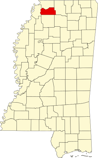
This is a list of the National Register of Historic Places listings in Marshall County, Mississippi.

National Register of Historic Places listings in Monroe County, Mississippi

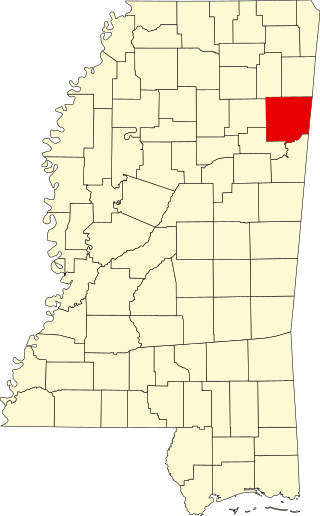
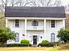
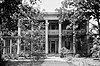
The following properties are listed on the National Register of Historic Places in Monroe County, Mississippi.

National Register of Historic Places listings in Oktibbeha County, Mississippi

This is a list of the National Register of Historic Places listings in Oktibbeha County, Mississippi.

National Register of Historic Places listings in Alcorn County, Mississippi

This is a list of the National Register of Historic Places listings in Alcorn County, Mississippi.

National Register of Historic Places listings in Tishomingo County, Mississippi

This is a list of the National Register of Historic Places listings in Tishomingo County, Mississippi.

National Register of Historic Places listings in Forrest County, Mississippi

This is a list of the National Register of Historic Places listings in Forrest County, Mississippi.

National Register of Historic Places listings in Washington County, Mississippi

This is a list of the National Register of Historic Places listings in Washington County, Mississippi.

National Register of Historic Places listings in Mississippi County, Missouri

This is a list of the National Register of Historic Places listings in Mississippi County, Missouri.

National Register of Historic Places listings in Pemiscot County, Missouri

This is a list of the National Register of Historic Places listings in Pemiscot County, Missouri.

National Register of Historic Places listings in Scott County, Missouri

This is a list of the National Register of Historic Places listings in Scott County, Missouri.

National Register of Historic Places listings in Ste. Genevieve County, Missouri

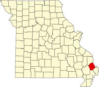
This is a list of the National Register of Historic Places listings in Ste. Genevieve County, Missouri.

References

  1. The latitude and longitude information provided in this table was derived originally from the National Register Information System, which has been found to be fairly accurate for about 99% of listings. Some locations in this table may have been corrected to current GPS standards.
  2. National Park Service, United States Department of the Interior, "National Register of Historic Places: Weekly List Actions", retrieved March 18, 2022.
  3. Numbers represent an alphabetical ordering by significant words. Various colorings, defined here, differentiate National Historic Landmarks and historic districts from other NRHP buildings, structures, sites or objects.
  4. "National Register Information System". National Register of Historic Places . National Park Service. March 13, 2009.
  5. The eight-digit number below each date is the number assigned to each location in the National Register Information System database, which can be viewed by clicking the number.
  6. Location derived from its NHL nomination form; the NRIS lists the site as "Address Restricted"