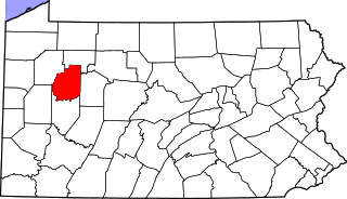
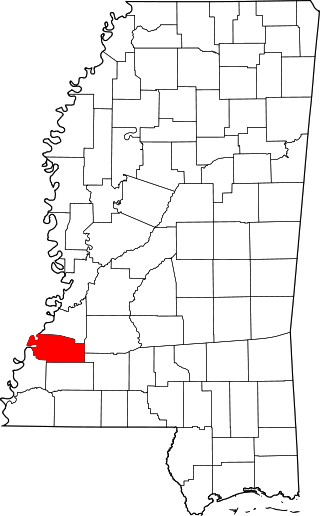
[3] Name on the Register [4] Image Date listed [5] Location City or town Description 1 505-507-509 North Farish Street Upload image July 30, 2024 (# 100010598 505-507-509 North Farish Street 32°18′18″N 90°11′19″W / 32.3051°N 90.1887°W / 32.3051; -90.1887 (505-507-509 North Farish Street ) Jackson 2 Admiral Benbow Inn Admiral Benbow Inn September 18, 2020 (# 100005613 905 North State St. 32°18′37″N 90°10′42″W / 32.3103°N 90.1783°W / 32.3103; -90.1783 (Admiral Benbow Inn ) Jackson 3 Ayer Hall Ayer Hall July 14, 1977 (# 77000788 1400 Lynch St. on the Jackson State University campus 32°17′45″N 90°12′27″W / 32.2958°N 90.2075°W / 32.2958; -90.2075 (Ayer Hall ) Jackson 4 Bailey Hill Civil War Earthworks Bailey Hill Civil War Earthworks May 6, 1975 (# 75001044 Off U.S. Route 51 32°16′27″N 90°11′57″W / 32.2742°N 90.1992°W / 32.2742; -90.1992 (Bailey Hill Civil War Earthworks ) Jackson 5 Baldwin's Ferry Mound Upload image September 24, 1998 (# 98001158 Address restricted [6] Newman 6 Bardin Mound (22-Hi-537) Upload image March 1, 1987 (# 87000130 Address restricted [6] Coxs Ferry 7 Belhaven Heights Historic District Belhaven Heights Historic District November 25, 1983 (# 83003958 Bellevue Place, N. Jefferson, Madison, and Morningside Sts.; also roughly bounded by Fortification, North, Monroe, and Spenglar Sts. 32°18′33″N 90°10′28″W / 32.3092°N 90.1744°W / 32.3092; -90.1744 (Belhaven Heights Historic District ) Jackson Second set of boundaries represents a boundary increase of September 3, 1998 8 Belhaven Historic District Belhaven Historic District December 19, 2012 (# 12000920 Roughly bounded by E. Fortification, & N. State Sts., I-55, & Riverside Dr. 32°19′03″N 90°10′04″W / 32.3174°N 90.1678°W / 32.3174; -90.1678 (Belhaven Historic District ) Jackson 9 Bellevue Court Apartments Bellevue Court Apartments November 21, 1994 (# 94001336 950 North St. 32°18′39″N 90°10′33″W / 32.3108°N 90.1758°W / 32.3108; -90.1758 (Bellevue Court Apartments ) Jackson 10 Berry Mound and Village Archeological Site Upload image November 25, 1969 (# 69000088 Address restricted [6] Terry 11 Big Black River Battlefield Big Black River Battlefield November 23, 1971 (# 71000451 On both banks of the Big Black River between Smith's Station and Bovina 32°21′36″N 90°43′35″W / 32.36°N 90.7264°W / 32.36; -90.7264 (Big Black River Battlefield ) Smith's Station Site of the Battle of Big Black River Bridge ; extends into Warren County 12 Big Black River Railroad Bridge Big Black River Railroad Bridge November 16, 1988 (# 88002418 Spans the Big Black River east of Bovina 32°20′49″N 90°42′17″W / 32.3469°N 90.7047°W / 32.3469; -90.7047 (Big Black River Railroad Bridge ) Edwards Extends into Warren County 13 Lillian Boteler House Upload image July 15, 1986 (# 86001703 214 Port Gibson Rd. 32°15′28″N 90°25′27″W / 32.2578°N 90.4242°W / 32.2578; -90.4242 (Lillian Boteler House ) Raymond 14 Building at 733 North State Street Building at 733 North State Street September 7, 2021 (# 100006899 733 North State St. 32°18′27″N 90°10′44″W / 32.3075°N 90.1789°W / 32.3075; -90.1789 (Building at 733 North State Street ) Jackson 15 Byram Bridge Byram Bridge May 23, 1979 (# 79003427 Old Byram and Florence Rd. 32°10′35″N 90°14′37″W / 32.1764°N 90.2436°W / 32.1764; -90.2436 (Byram Bridge ) Byram Extends into Rankin County 16 Calvary Baptist Church Calvary Baptist Church May 14, 2013 (# 13000301 1300 W. Capitol St. 32°18′31″N 90°12′09″W / 32.3087°N 90.2025°W / 32.3087; -90.2025 (Calvary Baptist Church ) Jackson 17 Capitol Green Capitol Green November 25, 1969 (# 69000083 Bounded on the north by Amite St., on the south by Pearl St., on the west by State St., and on the east by the Gulf, Mobile and Ohio railroad line 32°17′56″N 90°10′47″W / 32.2989°N 90.1797°W / 32.2989; -90.1797 (Capitol Green ) Jackson The green includes the War Memorial Building , and a Confederate memorial. 18 Casey Elementary School Upload image January 25, 2018 (# 100002029 2101 Lake Cir. 32°20′36″N 90°08′28″W / 32.3434°N 90.1410°W / 32.3434; -90.1410 (Casey Elementary School ) Jackson 19 Castle Crest Castle Crest March 22, 2010 (# 10000131 114 Woodland Circle 32°20′10″N 90°10′13″W / 32.3361°N 90.1702°W / 32.3361; -90.1702 (Castle Crest ) Jackson 20 John F. Cates House John F. Cates House May 16, 1985 (# 85001076 Mississippi Highway 22 32°27′06″N 90°25′13″W / 32.4517°N 90.4203°W / 32.4517; -90.4203 (John F. Cates House ) Brownsville 21 The Cedars The Cedars January 4, 1977 (# 77000787 405 E. College St. 32°20′14″N 90°19′26″W / 32.3372°N 90.3239°W / 32.3372; -90.3239 (The Cedars ) Clinton 22 Central Fire Station Central Fire Station October 30, 1975 (# 75001045 S. President St. 32°17′53″N 90°10′55″W / 32.2981°N 90.1819°W / 32.2981; -90.1819 (Central Fire Station ) Jackson 23 Chambliss Building Chambliss Building March 22, 2004 (# 04000219 932 Lynch St. 32°17′57″N 90°12′03″W / 32.2992°N 90.2008°W / 32.2992; -90.2008 (Chambliss Building ) Jackson 24 Champion Hill Battlefield Champion Hill Battlefield October 7, 1971 (# 71000450 4 miles southwest of Bolton 32°19′12″N 90°32′33″W / 32.32°N 90.5425°W / 32.32; -90.5425 (Champion Hill Battlefield ) Bolton 25 City Hall City Hall November 25, 1969 (# 69000084 203 S. President St. 32°17′52″N 90°10′56″W / 32.2978°N 90.1822°W / 32.2978; -90.1822 (City Hall ) Jackson 26 City Mound (22Hi672) Upload image December 1, 1988 (# 88002703 Address restricted [6] Jackson 27 Clinton Olde Towne Historic District Upload image January 12, 2017 (# 100000537 Bounded by Belmont, East, College & Capitol/West Sts. 32°20′22″N 90°19′50″W / 32.3395°N 90.3306°W / 32.3395; -90.3306 (Clinton Olde Towne Historic District ) Clinton 28 Downtown Fondren Historic District Downtown Fondren Historic District September 10, 2014 (# 14000566 Roughly along N. State St., Old Canton Rd., Duling Ave. & Fondren Pl. 32°20′07″N 90°10′32″W / 32.3352°N 90.1755°W / 32.3352; -90.1755 (Downtown Fondren Historic District ) Jackson 29 Dupree House Upload image January 31, 1979 (# 79001314 West of Raymond on Dupree Rd. 32°15′21″N 90°30′25″W / 32.2558°N 90.5069°W / 32.2558; -90.5069 (Dupree House ) Raymond 30 Dupree Mound and Village Archeological Site Upload image November 25, 1969 (# 69000082 Address restricted [6] Edwards 31 Dupree-Ratliff House Dupree-Ratliff House July 15, 1986 (# 86001704 101 Dupree St. 32°15′43″N 90°25′33″W / 32.2619°N 90.4258°W / 32.2619; -90.4258 (Dupree-Ratliff House ) Raymond 32 East Clinton Historic District East Clinton Historic District July 11, 1997 (# 97000631 Roughly bounded by the Illinois Central railroad tracks, E. College, Landrum, E. Main, and New Prospect Sts. 32°20′16″N 90°19′50″W / 32.3378°N 90.3306°W / 32.3378; -90.3306 (East Clinton Historic District ) Clinton 33 East Midtown Historic District Upload image September 16, 2022 (# 100008166 Roughly bounded by Adelle, North West, Nearview, and Blair Sts. 32°18′57″N 90°11′04″W / 32.3158°N 90.1844°W / 32.3158; -90.1844 (East Midtown Historic District ) Jackson 34 Edwards Hotel Edwards Hotel November 7, 1976 (# 76001096 Capitol and Mill Sts. 32°17′59″N 90°11′25″W / 32.2997°N 90.1903°W / 32.2997; -90.1903 (Edwards Hotel ) Jackson 35 Medgar Evers Historic District Medgar Evers Historic District September 18, 2013 (# 13000737 Roughly Margaret Walker Alexander St., W. of Missouri & E. of Miami Sts. 32°20′27″N 90°12′39″W / 32.3407°N 90.2107°W / 32.3407; -90.2107 (Medgar Evers Historic District ) Jackson 36 Medgar and Myrlie Evers Home National Monument Medgar and Myrlie Evers Home National Monument December 5, 2000 (# 00001459 2332 Margaret Walker Alexander Dr. 32°20′28″N 90°12′46″W / 32.3410°N 90.2127°W / 32.3410; -90.2127 (Medgar and Myrlie Evers Home National Monument ) Jackson 37 Meyer and Genevieve Falk House Upload image February 23, 2021 (# 100006163 2037 Eastbourne Pl. 32°20′30″N 90°08′19″W / 32.3417°N 90.1386°W / 32.3417; -90.1386 (Meyer and Genevieve Falk House ) Jackson 38 Farish Street Neighborhood Historic District Farish Street Neighborhood Historic District March 13, 1980 (# 80002245 Roughly bounded by Amite, Mill, Fortification, and Lamar Sts.; also roughly bounded by Amite, Lamar, Mill and Fortification Sts. 32°18′24″N 90°11′16″W / 32.3067°N 90.1878°W / 32.3067; -90.1878 (Farish Street Neighborhood Historic District ) Jackson Second set of boundaries represents a boundary increase of September 18, 1980 39 Floyd Mound Upload image November 25, 1969 (# 69000081 Address restricted [6] Bovina 40 Fountainhead Fountainhead November 28, 1980 (# 80002246 306 Glen Way 32°20′09″N 90°10′08″W / 32.3358°N 90.1689°W / 32.3358; -90.1689 (Fountainhead ) Jackson 41 James M. Futch House Upload image March 12, 1992 (# 92000144 Dry Grove Rd., 1½ miles south of its junction with Mississippi Highway 18 32°13′09″N 90°25′31″W / 32.2192°N 90.4253°W / 32.2192; -90.4253 (James M. Futch House ) Raymond The structure was purchased in 1993 and relocated nine miles northeast on Dupree Rd to save it from demolition. It has been restore as a private dwelling. 42 Galloway-Williams House Galloway-Williams House October 10, 1985 (# 85003100 427 E. Fortification St. 32°18′42″N 90°10′50″W / 32.3117°N 90.1806°W / 32.3117; -90.1806 (Galloway-Williams House ) Jackson 43 George Street Grocery George Street Grocery July 8, 2010 (# 10000438 416 George St. 32°18′23″N 90°10′55″W / 32.3064°N 90.1819°W / 32.3064; -90.1819 (George Street Grocery ) Jackson 44 Gibbs-Von Seutter House Gibbs-Von Seutter House July 15, 1986 (# 86001705 Southern side of Dupree St. 32°15′42″N 90°25′33″W / 32.2617°N 90.4258°W / 32.2617; -90.4258 (Gibbs-Von Seutter House ) Raymond 45 Garner Wynn Green House Garner Wynn Green House October 31, 1985 (# 85003440 647 N. State St. 32°18′20″N 90°10′45″W / 32.305556°N 90.179167°W / 32.305556; -90.179167 (Garner Wynn Green House ) Jackson 46 Greenwood Cemetery Greenwood Cemetery December 20, 1984 (# 84000474 Bounded by West, Davis, Lamar, and George Sts. 32°18′30″N 90°11′00″W / 32.308333°N 90.183333°W / 32.308333; -90.183333 (Greenwood Cemetery ) Jackson 47 Griffith Memorial Baptist Church Upload image September 15, 2022 (# 100008165 519 West Silas Brown St. 32°17′28″N 90°11′46″W / 32.2911°N 90.1960°W / 32.2911; -90.1960 (Griffith Memorial Baptist Church ) Jackson 48 R.H. Henry Bridge R.H. Henry Bridge June 8, 2005 (# 05000563 U.S. Route 80 at the Big Black River 32°20′51″N 90°41′49″W / 32.3475°N 90.696944°W / 32.3475; -90.696944 (R.H. Henry Bridge ) Edwards 49 Hinds County Armory Hinds County Armory December 1, 2000 (# 00001462 1012 Mississippi St. 32°18′07″N 90°10′27″W / 32.301944°N 90.174167°W / 32.301944; -90.174167 (Hinds County Armory ) Jackson 50 Hinds County Courthouse Hinds County Courthouse July 31, 1986 (# 86002125 Pascagoula St. 32°17′48″N 90°10′58″W / 32.296667°N 90.182778°W / 32.296667; -90.182778 (Hinds County Courthouse ) Jackson 51 Hinds County Courthouse Hinds County Courthouse July 15, 1986 (# 86001706 E. Main and N. Oak Sts. 32°15′37″N 90°25′24″W / 32.260278°N 90.423333°W / 32.260278; -90.423333 (Hinds County Courthouse ) Raymond 52 Holly Grove Plantation House Holly Grove Plantation House November 7, 1996 (# 96001313 1056 Old Bridgeport Rd. 32°23′25″N 90°25′04″W / 32.390278°N 90.417778°W / 32.390278; -90.417778 (Holly Grove Plantation House ) Bolton 53 Houses at 500, 505, 512 and 513 North State Street Houses at 500, 505, 512 and 513 North State Street November 7, 1995 (# 95001249 500, 505, 512, and 513 N. State St. 32°18′13″N 90°10′45″W / 32.303611°N 90.179167°W / 32.303611; -90.179167 (Houses at 500, 505, 512 and 513 North State Street ) Jackson 54 Illinois Central Railroad Depot Illinois Central Railroad Depot July 15, 1986 (# 86001707 E. Main and Railroad Sts. 32°15′30″N 90°25′18″W / 32.258333°N 90.421667°W / 32.258333; -90.421667 (Illinois Central Railroad Depot ) Raymond 55 Illinois Central Railroad Depot Illinois Central Railroad Depot November 5, 2001 (# 01001200 102 Railroad Ave. 32°05′42″N 90°17′35″W / 32.095°N 90.293056°W / 32.095; -90.293056 (Illinois Central Railroad Depot ) Terry 56 Jackson Holiday Inn Southwest Upload image October 16, 2023 (# 100009438 2649 US 80 West 32°17′30″N 90°13′52″W / 32.2918°N 90.2310°W / 32.2918; -90.2310 (Jackson Holiday Inn Southwest ) Jackson 57 Dudley Jones House Dudley Jones House August 2, 1984 (# 84002218 115 Railroad Ave. 32°05′42″N 90°17′41″W / 32.095°N 90.294722°W / 32.095; -90.294722 (Dudley Jones House ) Terry 58 Keith Press Building Keith Press Building July 15, 1986 (# 86001708 234 Town Sq. 32°15′35″N 90°25′21″W / 32.259722°N 90.4225°W / 32.259722; -90.4225 (Keith Press Building ) Raymond 59 Lanier Junior-Senior High School (Colored) Lanier Junior-Senior High School (Colored) September 10, 2014 (# 14000567 833 Maple St. 32°18′59″N 90°12′10″W / 32.3164°N 90.2028°W / 32.3164; -90.2028 (Lanier Junior-Senior High School (Colored) ) Jackson 60 Lebanon Presbyterian Church Lebanon Presbyterian Church November 18, 1999 (# 99001359 Lebanon Presbyterian Church Rd. 32°08′55″N 90°31′22″W / 32.148611°N 90.522778°W / 32.148611; -90.522778 (Lebanon Presbyterian Church ) Utica 61 Leonard Court Historic District Upload image May 8, 2024 (# 83000952 Leonard and Botnick Courts, between Farish and Mill Streets 32°18′34″N 90°11′24″W / 32.3094°N 90.1901°W / 32.3094; -90.1901 (Leonard Court Historic District ) Jackson 62 A.J. Lewis House A.J. Lewis House August 4, 1983 (# 83000952 S. Magnolia and Lewis Sts. 32°19′48″N 90°36′14″W / 32.33°N 90.603889°W / 32.33; -90.603889 (A.J. Lewis House ) Edwards 63 Ervin Lewis House Ervin Lewis House December 1, 1989 (# 89002052 5461 Old Byram Rd. 32°10′52″N 90°14′36″W / 32.181111°N 90.243333°W / 32.181111; -90.243333 (Ervin Lewis House ) Byram 64 Liberty Hall Liberty Hall March 19, 2008 (# 08000197 22822 Mississippi Highway 27 32°03′43″N 90°29′06″W / 32.062083°N 90.485033°W / 32.062083; -90.485033 (Liberty Hall ) Crystal Springs 65 Lorena Duling School Lorena Duling School July 3, 2007 (# 07000650 622 Duling Ave. 32°20′11″N 90°10′33″W / 32.336270°N 90.175920°W / 32.336270; -90.175920 (Lorena Duling School ) Jackson 66 Magnolia Vale Magnolia Vale November 17, 1983 (# 83003960 Off Mississippi Highway 18 32°12′17″N 90°28′24″W / 32.204722°N 90.473333°W / 32.204722; -90.473333 (Magnolia Vale ) Raymond 67 Main Hall Main Hall July 15, 1986 (# 86001709 Northwest of Cain Hall 32°15′19″N 90°25′02″W / 32.255278°N 90.417222°W / 32.255278; -90.417222 (Main Hall ) Raymond 68 Manship House Manship House October 18, 1972 (# 72000693 412 E. Fortification St. 32°18′45″N 90°10′53″W / 32.3125°N 90.1814°W / 32.3125; -90.1814 (Manship House ) Jackson 69 McNair Plantation McNair Plantation May 3, 1982 (# 82003101 Southeast of Raymond on Mississippi Highway 18 32°10′19″N 90°30′30″W / 32.1719°N 90.5083°W / 32.1719; -90.5083 (McNair Plantation ) Raymond 70 McRae's Department Store at Meadowbrook Mart McRae's Department Store at Meadowbrook Mart March 3, 2015 (# 14000568 4206 N. State St. 32°20′59″N 90°10′26″W / 32.3497°N 90.1739°W / 32.3497; -90.1739 (McRae's Department Store at Meadowbrook Mart ) Jackson 71 Merrill-Maley House Merrill-Maley House April 29, 1982 (# 82003100 739 N. State St. 32°18′27″N 90°10′44″W / 32.3075°N 90.1789°W / 32.3075; -90.1789 (Merrill-Maley House ) Jackson 72 Millsaps-Buie House Millsaps-Buie House June 19, 1973 (# 73001014 628 N. State St. 32°18′18″N 90°10′43″W / 32.305°N 90.1786°W / 32.305; -90.1786 (Millsaps-Buie House ) Jackson 73 Mississippi Federation of Women's Clubs Mississippi Federation of Women's Clubs June 30, 1988 (# 88000975 2407 N. State St. 32°19′37″N 90°10′33″W / 32.3269°N 90.1758°W / 32.3269; -90.1758 (Mississippi Federation of Women's Clubs ) Jackson 74 Mississippi Foundry and Machine Company Building Mississippi Foundry and Machine Company Building July 16, 2008 (# 08000674 300 W. South St. 32°20′25″N 90°10′02″W / 32.3402°N 90.1672°W / 32.3402; -90.1672 (Mississippi Foundry and Machine Company Building ) Jackson 75 Mississippi Governor's Mansion Mississippi Governor's Mansion November 25, 1969 (# 69000085 316 E. Capitol St. 32°18′00″N 90°11′00″W / 32.3°N 90.1833°W / 32.3; -90.1833 (Mississippi Governor's Mansion ) Jackson 76 Mississippi State Capitol Mississippi State Capitol November 25, 1969 (# 69000086 Fronting Mississippi St., between N. President and N. West Sts. 32°18′56″N 90°11′49″W / 32.3156°N 90.1969°W / 32.3156; -90.1969 (Mississippi State Capitol ) Jackson The "New Capitol" building, built in 1903; designated a National Historic Landmark in 2016. 77 Morris Ice Company Upload image May 16, 2019 (# 100003950 652 Commerce St. 32°17′33″N 90°10′49″W / 32.2925°N 90.1803°W / 32.2925; -90.1803 (Morris Ice Company ) Jackson 78 Joseph Henry Morris House Joseph Henry Morris House August 11, 1983 (# 83000953 305 N. State St. 32°18′13″N 90°10′47″W / 32.3036°N 90.1797°W / 32.3036; -90.1797 (Joseph Henry Morris House ) Jackson 79 Mt. Olive Cemetery Upload image June 5, 2017 (# 100001028 900 blk. of John R. Lynch St. 32°17′51″N 90°12′10″W / 32.2974°N 90.2028°W / 32.2974; -90.2028 (Mt. Olive Cemetery ) Jackson 80 Municipal Art Gallery Municipal Art Gallery March 27, 2012 (# 12000154 839 N. State St. 32°18′36″N 90°10′43″W / 32.3099°N 90.1785°W / 32.3099; -90.1785 (Municipal Art Gallery ) Jackson 81 N&W Overall Company Building N&W Overall Company Building November 14, 2007 (# 07001180 736 S. President St. 32°17′33″N 90°10′58″W / 32.2925°N 90.1828°W / 32.2925; -90.1828 (N&W Overall Company Building ) Jackson 82 Naval and Marine Corps Reserve Center Naval and Marine Corps Reserve Center November 19, 2002 (# 02000209 181 S. Jefferson St. 32°18′00″N 90°10′42″W / 32.3°N 90.1783°W / 32.3; -90.1783 (Naval and Marine Corps Reserve Center ) Jackson 83 New Orleans Great Northern Railroad Passenger Depot New Orleans Great Northern Railroad Passenger Depot March 1, 1996 (# 96000188 618 Pearl St. 32°17′54″N 90°10′45″W / 32.2983°N 90.1792°W / 32.2983; -90.1792 (New Orleans Great Northern Railroad Passenger Depot ) Jackson 84 North Manor Apartments North Manor Apartments March 3, 1995 (# 95000177 909 North St. 32°18′37″N 90°10′37″W / 32.3103°N 90.1769°W / 32.3103; -90.1769 (North Manor Apartments ) Jackson 85 The Oaks The Oaks May 25, 1973 (# 73001015 823 N. Jefferson St. 32°18′32″N 90°10′34″W / 32.3089°N 90.1761°W / 32.3089; -90.1761 (The Oaks ) Jackson 86 Old State Capitol Old State Capitol November 25, 1969 (# 69000087 100 N. State St. 32°17′57″N 90°10′48″W / 32.299167°N 90.18000°W / 32.299167; -90.18000 (Old State Capitol ) Jackson 87 Old Terminal Building, Hawkins Field Upload image September 9, 2020 (# 100005578 Airport Dr. 32°19′41″N 90°13′00″W / 32.3280°N 90.2168°W / 32.3280; -90.2168 (Old Terminal Building, Hawkins Field ) Jackson 88 Peyton House Peyton House October 3, 1973 (# 73001016 North of Raymond on Clinton Rd. 32°16′01″N 90°25′12″W / 32.2669°N 90.42°W / 32.2669; -90.42 (Peyton House ) Raymond 89 Phoenix Hall-Johnson-Harper House Phoenix Hall-Johnson-Harper House July 15, 1986 (# 86001710 527 E. Palestine St. 32°15′12″N 90°25′09″W / 32.2533°N 90.4192°W / 32.2533; -90.4192 (Phoenix Hall-Johnson-Harper House ) Raymond 90 Pocahontas Mound A Pocahontas Mound A November 25, 1969 (# 69000365 In a park along U.S. Route 49 , near its junction with Interstate 220 [7] 32°28′09″N 90°17′18″W / 32.4693°N 90.2883°W / 32.4693; -90.2883 (Pocahontas Mound A ) Pocahontas 91 Pocahontas Mound B Upload image April 11, 1972 (# 72000694 Address restricted [6] Pocahontas 92 Poindexter Park Historic District Poindexter Park Historic District June 9, 1995 (# 95000685 Roughly bounded by W. Pearl St., Rose St., Hunt St., W. Capitol St., and Clifton St. 32°18′06″N 90°11′53″W / 32.3017°N 90.1981°W / 32.3017; -90.1981 (Poindexter Park Historic District ) Jackson 93 Porter House Porter House July 15, 1986 (# 86001702 233 North Oak St. 32°15′41″N 90°25′21″W / 32.2614°N 90.4225°W / 32.2614; -90.4225 (Porter House ) Raymond 94 Raymond Battlefield Site Raymond Battlefield Site January 13, 1972 (# 72000695 2.5 miles southwest of Raymond on Mississippi Highway 18 32°14′30″N 90°27′00″W / 32.2417°N 90.45°W / 32.2417; -90.45 (Raymond Battlefield Site ) Raymond Site of the Battle of Raymond 95 Raymond Historic District Raymond Historic District July 27, 2007 (# 07000749 Roughly Town Sq., with parts of E. Main, Palestine, Cooper's Well, Clinton, Oak, Court, W. Main, Dupree, and Port Gibson 32°15′34″N 90°25′22″W / 32.2595°N 90.4229°W / 32.2595; -90.4229 (Raymond Historic District ) Raymond 96 Dr. Jacob and Mrs. Daisy Reddix House Upload image January 5, 2024 (# 100009008 1136 Valley St. 32°17′55″N 90°12′57″W / 32.2987°N 90.2159°W / 32.2987; -90.2159 (Dr. Jacob and Mrs. Daisy Reddix House ) Jackson 97 Smith Robertson Elementary School Smith Robertson Elementary School December 13, 1978 (# 78001601 528 Bloom St. 32°18′19″N 90°11′11″W / 32.3053°N 90.1864°W / 32.3053; -90.1864 (Smith Robertson Elementary School ) Jackson 98 Saint Mark's Episcopal Church Saint Mark's Episcopal Church July 15, 1986 (# 86001712 W. Main and N. Oak Sts. 32°15′38″N 90°25′26″W / 32.2606°N 90.4239°W / 32.2606; -90.4239 (Saint Mark's Episcopal Church ) Raymond 99 Shelton House Shelton House July 15, 1986 (# 86001711 561 W. Main St. 32°16′00″N 90°25′40″W / 32.2667°N 90.4278°W / 32.2667; -90.4278 (Shelton House ) Raymond 100 Sims House Sims House March 31, 1983 (# 83000954 513 N. State St. 32°18′14″N 90°10′46″W / 32.3039°N 90.1794°W / 32.3039; -90.1794 (Sims House ) Jackson 101 Smith Apartments Upload image July 20, 2020 (# 100005036 1047 Smith Dr. 32°15′02″N 90°26′15″W / 32.2505°N 90.4376°W / 32.2505; -90.4376 (Smith Apartments ) Raymond 102 Smith Park Architectural District Smith Park Architectural District April 23, 1976 (# 76001097 Irregular pattern along N. West and N. Congress Sts. between Capitol St. and the state capitol; also 225 E. Capitol St.; also 308 E. Pearl St.; also 200 blk. E. Capitol St. 32°18′02″N 90°11′00″W / 32.3006°N 90.1833°W / 32.3006; -90.1833 (Smith Park Architectural District ) Jackson Capitol and Pearl addresses represent boundary increases of October 29, 1993 and March 24, 2004 respectively; a third boundary increase was listed July 25, 2014 , and a fourth was added October 16, 2023 103 Southern Christian Institute Southern Christian Institute January 30, 2007 (# 06001323 18449 Old U.S. Route 80 , W. 32°20′17″N 90°38′16″W / 32.3380°N 90.6377°W / 32.3380; -90.6377 (Southern Christian Institute ) Edwards 104 Southwest Midtown Historic District Upload image October 4, 2019 (# 100004504 Roughly bounded by Whitfield St., Blair St., East Bell St., and North Mill St. 32°18′53″N 90°11′16″W / 32.3148°N 90.1878°W / 32.3148; -90.1878 (Southwest Midtown Historic District ) Jackson 105 Pearl Spann Elementary School Upload image January 25, 2018 (# 100002030 1615 Brecon Dr. 32°21′33″N 90°08′29″W / 32.3592°N 90.1414°W / 32.3592; -90.1414 (Pearl Spann Elementary School ) Jackson 106 Spengler's Corner Spengler's Corner October 20, 1977 (# 77000789 101 N. State St. 32°17′57″N 90°10′49″W / 32.2992°N 90.1803°W / 32.2992; -90.1803 (Spengler's Corner ) Jackson 107 Spengler's Corner Historic District Spengler's Corner Historic District November 15, 1979 (# 79001311 E. Capitol, N. State, and N. President Sts; also 400 blk. E. Capitol, 100-300 blks N. State & 100 blk. N. & S. President Sts. 32°17′57″N 90°10′50″W / 32.2992°N 90.1806°W / 32.2992; -90.1806 (Spengler's Corner Historic District ) Jackson Second set of addresses represent a boundary increase approved January 24, 2019 108 Spengler-Thomas Building Spengler-Thomas Building May 9, 2003 (# 03000387 129 S. President 32°18′00″N 90°10′55″W / 32.3°N 90.1819°W / 32.3; -90.1819 (Spengler-Thomas Building ) Jackson 109 Stamp's Super Burgers Upload image December 4, 2023 (# 100009009 1801 Dalton St. 32°17′26″N 90°12′21″W / 32.2906°N 90.2059°W / 32.2906; -90.2059 (Stamp's Super Burgers ) Jackson 110 Sub Rosa Sub Rosa April 28, 1975 (# 75001046 South of Pocahontas on U.S. Route 49 32°26′31″N 90°17′35″W / 32.4419°N 90.2931°W / 32.4419; -90.2931 (Sub Rosa ) Pocahontas 111 Tanglewood Tanglewood September 18, 2013 (# 13000738 301 Jefferson St. 32°20′21″N 90°19′51″W / 32.3393°N 90.3309°W / 32.3393; -90.3309 (Tanglewood ) Clinton 112 Upper Midtown Historic District Upload image October 3, 2014 (# 100004503 Roughly bounded by Duncan Ave., N. West St., McTyere Ave. & North Mill St.; also, roughly bounded by Duncan Ave., North West, Livingston, & North Mill Sts. 32°19′21″N 90°11′08″W / 32.3225°N 90.1856°W / 32.3225; -90.1856 (Upper Midtown Historic District ) Jackson Second set of addresses represent a boundary increase approved September 16, 2022. 113 Virden-Patton House Virden-Patton House December 16, 1983 (# 83003962 512 N. State St. 32°18′13″N 90°10′44″W / 32.3036°N 90.1789°W / 32.3036; -90.1789 (Virden-Patton House ) Jackson 114 Warren-Guild-Simmons House Warren-Guild-Simmons House January 11, 1979 (# 79001312 734 Fairview St. 32°19′13″N 90°10′36″W / 32.3203°N 90.1767°W / 32.3203; -90.1767 (Warren-Guild-Simmons House ) Jackson 115 Waterhouse-Simmons House Upload image May 11, 2018 (# 100002422 646 Seneca Ave. 32°20′28″N 90°10′23″W / 32.3412°N 90.1731°W / 32.3412; -90.1731 (Waterhouse-Simmons House ) Jackson 116 Eudora Welty House Eudora Welty House November 21, 2002 (# 02001388 1119 Pinehurst St. 32°19′08″N 90°10′13″W / 32.3189°N 90.1703°W / 32.3189; -90.1703 (Eudora Welty House ) Jackson 117 West Capitol Street Historic District West Capitol Street Historic District March 13, 1980 (# 80002248 Roughly bounded by railroad tracks and Amite, Roach, and Pearl Sts. 32°18′02″N 90°11′24″W / 32.3006°N 90.19°W / 32.3006; -90.19 (West Capitol Street Historic District ) Jackson 118 Wiener House at 228 Ridge Drive Wiener House at 228 Ridge Drive November 2, 2009 (# 09000884 228 Ridge Dr. 32°20′25″N 90°10′02″W / 32.3402°N 90.1672°W / 32.3402; -90.1672 (Wiener House at 228 Ridge Drive ) Jackson 119 Dr. Julian and Kathryn Wiener House Upload image February 8, 2021 (# 100006137 3858 Redbud Rd. 32°20′21″N 90°08′25″W / 32.3392°N 90.1404°W / 32.3392; -90.1404 (Dr. Julian and Kathryn Wiener House ) Jackson 120 Alex Williams House Alex Williams House July 3, 1979 (# 79001313 937 N. Lamar St. 32°18′33″N 90°11′04″W / 32.3092°N 90.1844°W / 32.3092; -90.1844 (Alex Williams House ) Jackson 121 Woodrow Wilson Bridge Woodrow Wilson Bridge November 16, 1988 (# 88002485 Spans the Pearl River on Silas Brown St. 32°17′22″N 90°10′44″W / 32.2894°N 90.1789°W / 32.2894; -90.1789 (Woodrow Wilson Bridge ) Jackson Extends into Rankin County 122 Wolfe House Wolfe House June 22, 1989 (# 89000762 401 Claiborne 32°05′48″N 90°17′56″W / 32.0967°N 90.2989°W / 32.0967; -90.2989 (Wolfe House ) Terry