
Kyaukse is a town and the capital of Kyaukse District in Mandalay Region, Myanmar. Lying on the Zawgyi River, 25 miles (40 km) south of Mandalay, it is served by the Mandalay-Yangon (Rangoon) railway. The first Myanmar probably settled in the area about 800, and local 12th- and 13th-century inscriptions refer to Kyaukse as “the first home”. Remains of pagodas and old cities are found throughout the area. The Shwethalyaung Pagoda, built by King Anawrahta (1044–77), is located in Kyaukse.

Mount Popa is a dormant volcano 1518 metres (4981 feet) above sea level, and located in central Myanmar in the region of Mandalay about 50 km (31 mi) southeast of Bagan (Pagan) in the Pegu Range. It can be seen from the Ayeyarwady (Irrawaddy) River as far away as 60 km (37 mi) in clear weather. Mount Popa is a pilgrimage site, with numerous Nat temples and relic sites atop the mountain.

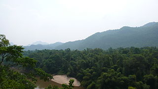
The Chin Hills-Arakan Yoma montane forests is a tropical and subtropical moist broadleaf forest ecoregion in western Myanmar (Burma). Surrounded at lower elevations by moist tropical forests, this ecoregion is home a diverse range of subtropical and temperate species, including many species characteristic of the Himalayas, as well as many endemic species.

Nat Ma Taung, also known as Mount Victoria, is the highest mountain in the Chin State of western Myanmar.

The white-browed nuthatch, also known as the Victoria nuthatch, is a species of bird in the family Sittidae. It is a small nuthatch, measuring 11.5 cm (4.5 in) in length and without sexual dimorphism. Like many other nuthatches, the upperparts are gray-blue, contrasting with white underparts on the throat, cheeks, and breast and orange on the flanks, belly, and lower abdomen. Its white supercilium makes it easy to distinguish it from the white-tailed nuthatch, which is a close species in the systematic and geographical sense. Little is known about its ecology, but it feeds on small insects found among bark and lichens, and breeding occurs around April.
Kanpetlet is a town in the Chin State of West Myanmar and the home of the Kanpetlet Township administration body. It is known for Mt. Victoria, the highest peak in the Chin Hills and one of the highest in Western Myanmar, and Natmataung National Park, home of some of the world's rarest bird species.

Alaungdaw Kathapa National Park is a national park in Myanmar covering 541.6 sq mi (1,403 km2). It was established in 1989 and is listed as one of the ASEAN Heritage Parks. It spans an elevation of 443–4,380 ft (135–1,335 m) in the Kani and Mingin Townships in Sagaing Region.
The Tenasserim Hills or Tenasserim Range is the geographical name of a roughly 1,700 km long mountain chain, part of the Indo-Malayan mountain system in Southeast Asia.
Hkakaborazi National Park is a national park in northern Myanmar with an area of 1,472 sq mi (3,810 km2). It was established in 1998. It surrounds Hkakabo Razi, the highest mountain in the country.

Indawgyi Lake Wildlife Sanctuary is a biosphere reserve in Myanmar, covering 814.99 km2 (314.67 sq mi). It ranges in elevation from 105–1,400 m (344–4,593 ft) encompassing the surroundings of Indawgyi Lake in Mohnyin Township, Kachin State. It was gazetted in 2004, is recognized as an Important Bird Area and as one of the ASEAN Heritage Parks. An area of 478.84 km2 (184.88 sq mi) comprising the lake and the surrounding lowland is a Ramsar site since February 2016.
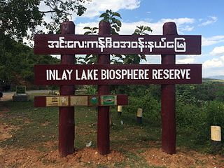
Inlay Lake Wetland Sanctuary is a protected area in Myanmar's Shan State, covering an area of 533.73 km2 (206.07 sq mi) surrounding Inle Lake. It ranges in elevation from 830 to 1,270 m, stretching over Nyaungshwe, Pinlaung and Pekon Townships. It was gazetted in 1985 to protect habitats for migratory birds. In 2003, it was designated as one of the ASEAN Heritage Parks, and in 2015 as the first Biosphere Reserve in the country.
Moeyungyi Wetland Wildlife Sanctuary is a protected area in Myanmar's Bago Division, covering an area of 103.6 km2 (40.0 sq mi). It was established in 1988 and gained the status of an Important Bird Area in 2003.
Lenya National Park is a proposed national park in Myanmar. It has been proposed since 2002 to be established in the Tenasserim Hills over an area of 680 sq mi (1,800 km2) and extended by 540 sq mi (1,400 km2) in 2004. The area comprises evergreen forest at elevations from 50 to 4,078 ft, which is governed by Myanmar's Forest Department. By 2011, the national park was not yet gazetted and its boundaries still not demarcated.

The Lampi Island Marine National Park is a marine national park in Myanmar covering 79.09 sq mi (204.8 km2). It was established in 1996. It encompasses Lanbi Island and several smaller islands in the Mergui Archipelago, comprising coral reefs, seagrass beds, mangroves, sand dunes and tropical evergreen forest up to an elevation of 1,493 ft (455 m). The national park is an Important Bird Area and one of the ASEAN Heritage Parks. The characteristics of the Marine National Park are the tropical evergreen rainforest, the vast coral reef systems that protect a wide range of aquatic ecosystems, and significant biodiversity in this area. Access is restricted to daytime visits.

Tanintharyi Nature Reserve is a strict nature reserve in Myanmar's Tenasserim Hills, covering 1,699.99 km2 (656.37 sq mi). In elevation, it ranges from at an elevation of 20–130 m (66–427 ft). Most of the tropical rain forest is evergreen, interspersed with some grassland. The reserve provides habitat to Asian elephant and Gurney's pitta. It was gazetted in 2005 for the maintenance of natural resources, scientific research and education of local people in surrounding communities.
Mulayit Wildlife Sanctuary is a protected area in Myanmar's Kayin State, covering 138.56 km2 (53.50 sq mi). It ranges in elevation from 80 to 2,010 m and encompasses grassland, evergreen forest and mixed deciduous forest in Kyain Seikgyi Township. It was gazetted in 1936. It is located on the western slopes of the Dawna Range and was established with the support of Buddhist monks.

The Dawna Range, also known as Dawna Hills, is a mountain range in eastern Burma and northwestern Thailand. Its northern end is located in Kayah State where it meets the Daen Lao Range, a subrange of the Shan Hills. The range runs southwards along Kayin State as a natural border with Mon State in the west forming parallel ranges to the northern end of the Tenasserim Hills further south and southeast. The Dawna Range extends east of the Salween southwards from the Shan Hills for about 350 km, at the western limit of the Thai highlands. Its southern end reaches the Thai-Myanmar border in the Umphang area, entering Thailand west of Kamphaeng Phet. The Thungyai Naresuan Wildlife Sanctuary is in the Thai side of the range.
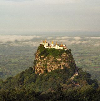
Taung Kalat is a Buddhist monastery and temple complex located on Mount Popa in Mandalay Region, Myanmar. The site is built on a tall volcanic plug, and is one of several prominent nat spiritual sites in the vicinity of nearby Mount Popa.
Kelatha Wildlife Sanctuary is a protected area in Myanmar stretching over 22.45 km2 (8.67 sq mi). It was established in 1942. It harbours evergreen and mixed deciduous forest with elevations ranging from 0 to 355 m (1,165 ft) in Bilin Township, Mon State. The sanctuary is administered from Bilin.
