Timpoong and Hibok-Hibok Natural Monument

Last updated
Timpoong and Hibok-Hibok Natural Monument
Hibok-Hibok Volcano Summit.jpg
Philippines relief location map (Mindanao).svg
Red pog.svg
Location in the Philippines
Philippines relief location map (square).svg
Red pog.svg
Timpoong and Hibok-Hibok Natural Monument (Philippines)
Location Camiguin, Philippines
Nearest city Cagayan de Oro
Coordinates 9°10′21″N124°43′24″E / 9.17250°N 124.72333°E / 9.17250; 124.72333
Area2,227.62 hectares (5,504.6 acres)
EstablishedMarch 9, 2004
Governing body Department of Environment and Natural Resources

Timpoong and Hibok-Hibok Natural Monument is a Philippine natural monument located in Northern Mindanao on the island of Camiguin. It encompasses two scenic volcanoes in the Camiguin Mindanao range that span the core of Camiguin: Mount Mambajao, which includes Mount Timpoong, its highest peak, and Mount Catarman, which includes Mount Hibok-Hibok, the island's only currently active volcano. [1] Established in 2004 through Proclamation No. 570 issued by President Gloria Arroyo, the natural monument is an important watershed containing the only remaining rainforest on Camiguin. [2] It supports a variety of endemic flora and fauna and is also noted for its waterfalls, rivers and springs. [1]

Contents

During the 13th ASEAN Ministerial Meeting on the Environment in 2015, the Timpoong and Hibok-Hibok monument was formally declared an ASEAN Heritage Park. [3]

Description

Katibawasan Falls in the Timpoong-Hibok-Hibok Natural Monument Katibawasan Falls, Camiguin.JPG
Katibawasan Falls in the Timpoong–Hibok-Hibok Natural Monument

The 2,227.62-hectare (5,504.6-acre) protected area stretches along the central and western interior of the island of Camiguin. It also includes a buffer zone of 182.91 hectares (452.0 acres) surrounding Mount Hibok-Hibok and 1,239.7 hectares (3,063 acres) surrounding Mount Timpoong, and extends into four of the five municipalities on the island: Mambajao, Catarman, Mahinog and Sagay. [2]

At 1,614 metres (5,295 ft) above sea level, Mount Timpoong is the highest peak of Mount Mambajao. Mambajao is the central and largest of the island's three volcanic mountains (the others being Mount Catarman and Mount Sagay, also known as Mount Guinsiliban). Mount Mambajao's other peaks are Mambajao Peak at 1,568 metres (5,144 ft) above sea level, and an unnamed peak with an elevation of 1,529 metres (5,016 ft). It has flank vents located on Campana Hill and Minokol Hill. [4] [1]

Located just northwest of Mambajao is Mount Catarman. Its highest peak is Mount Hibok-Hibok which measures 1,250 metres (4,100 ft) in elevation and is classified as an active stratovolcano. Mount Tres Marias and Mount Vulcan Daan (Old Volcano) are Mount Catarman's other peaks. [4] [1]

The protected area is also noted for its hydrological features, many of which are popular among tourists and hikers. They include waterfalls such as the Katibawasan, Binangawan and Tuasan Falls, cold and hot springs like those of Ardent and Santo Niño, and rivers such as Sagay and Binangawan rivers. It is also the location of the Hibok-Hibok Volcano Observatory of the Philippine Institute of Volcanology and Seismology. [5]

Flora and fauna

Timpoong and Hibok-Hibok comprises about 300 hectares (740 acres) of mossy forests at elevations above 1,100 metres (3,600 ft), 1,282 hectares (3,170 acres) of residual lowland dipterocarp forests at elevations above 500 metres (1,600 ft), and brush lands and open grasslands covering the remaining 1,585 hectares (3,920 acres). [6] The natural monument was established for the conservation of endangered and endemic fauna that live within those forests. They include one bird species and two mammals that can only be found in Camiguin: the Camiguin hanging parrot, and the Camiguin forest mouse and Camiguin forest rat. [1] Other fauna include the Camiguin hawk-owl, writhed hornbill, Mindanao shrew, Camiguin narrow-mouthed frog, big-eyed frog and small rufous horseshoe bat.

Its vegetation consists of tropical plants endemic to Camiguin such as Miguelia reticulata, Medinilla multiflora, Memecylon subcaudatum, Syzygium camiguense, Coelogyne confusa and Goodyera ramosii. [1]

Related Research Articles

<span class="mw-page-title-main">Mount Apo</span> Large, dormant Volcano in the Philippines

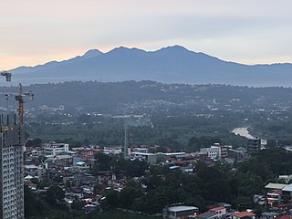
Mount Apo, also known locally as Apo Sandawa, is a large solfataric, dormant stratovolcano on the island of Mindanao, Philippines. With an elevation of 3,142.79 meters (10,311.0 ft) above sea level, it is the highest-mountain in the Philippine Archipelago, Mindanao and 24th-highest peak of an island on Earth. Located on the tripartite border of Davao City and Davao del Sur in the Davao Region, and Cotabato in Soccsksargen, Mount Apo is the most-prominent mountain in the Philippines. The peak overlooks from Davao City 45 kilometers (28 mi) to the northeast, Digos 25 kilometers (16 mi) to the southeast, and Kidapawan 20 kilometers (12 mi) to the west. It is a protected area and a Natural Park of the Philippines.

<span class="mw-page-title-main">Camiguin</span> Province in Northern Mindanao, Philippines

Camiguin, officially the Province of Camiguin, is an island province in the Philippines located in the Bohol Sea, about 10 kilometres (6.2 mi) off the northern coast of Mindanao. It is geographically part of Region X, the Northern Mindanao Region of the country and formerly a part of Misamis Oriental province.

<span class="mw-page-title-main">Mount Pulag</span> Volcano in the Philippines

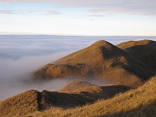
Mount Pulag is Luzon's highest peak at 2,928 metres (9,606 ft) above sea level, third-highest mountain in the Philippines, and the 26th-highest peak of an island on Earth. It is second-most prominent mountain in the Philippines, it is a dormant volcano. Located on the triple border of the provinces of Benguet, Ifugao, and Nueva Vizcaya, the borders meet at the mountain's peak. Mount Pulag is third highest next to Mount Apo and Mount Dulang-dulang.

<span class="mw-page-title-main">Mount Banahaw</span> Active volcano in the Philippines

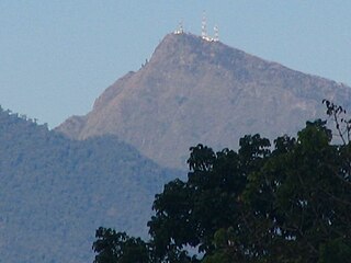
Mount Banahaw is an active complex volcano on Luzon in the Philippines. The three-peaked volcano is located at the boundary of Laguna and Quezon provinces. It is the highest mountain in both provinces and Calabarzon region, dominating the landscape for miles around.

<span class="mw-page-title-main">Mambajao</span> Capital of Camiguin, Philippines

Mambajao, officially the Municipality of Mambajao, is a 3rd class municipality and capital of the province of Camiguin, Philippines. According to the 2020 census, it has a population of 41,094 people.

Camiguin de Babuyanes is an active stratovolcano on Camiguin Island, part of the Babuyan Islands group that is located in Luzon Strait, north of the island of Luzon, in the Philippines. The volcano and the island are within the jurisdiction of the municipality of Calayan, in the province of Cagayan. The island has a population of 5,231 people in 2020.

<span class="mw-page-title-main">Mount Hibok-Hibok</span> Stratovolcano on Camiguin island in the Philippines

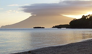
Mount Hibok-Hibok is a stratovolcano on Camiguin Island in the Philippines. It is one of the active volcanoes in the country and part of the Pacific ring of fire.

<span class="mw-page-title-main">Mount Iraya</span> Dormant stratovolcano on Batan Island, Philippines

Mount Iraya, is a dormant stratovolcano on Batan Island and the highest point in the province of Batanes, Philippines.

<span class="mw-page-title-main">Musuan Peak</span> Active volcano on Mindanao, Philippines

Musuan Peak or Mount Musuan, also known as Mount Calayo is an active volcano in Maramag, Bukidnon, on the island of Mindanao in the Philippines. It is 4.5 kilometres (2.8 mi) south of the city of Valencia, province of Bukidnon, and 81 kilometres (50 mi) southeast of Cagayan de Oro.

<span class="mw-page-title-main">Mount Isarog</span> Active Volcano in camarines sur mount isarog

Mount Isarog is an active stratovolcano located in the province of Camarines Sur, Philippines, on the island of Luzon. The mountain has active fumaroles and hot springs. It has an elevation of 2,011.6 m (6,600 ft) above mean sea level.

<span class="mw-page-title-main">Mount Kitanglad</span> Volcano in the Philippines

Mount Kitanglad is an inactive volcano located in the Kitanglad Mountain Range in Bukidnon province on Mindanao island. It is the fourth highest mountain in the Philippines and has an approximate height of 2,899 metres (9,511 ft). It is located between Malaybalay City and the municipalities of Lantapan, Impasugong, Sumilao, and Libona. It is home to one of the Philippines' few remaining rainforests.

<span class="mw-page-title-main">Mount Malindig</span> Volcano in the Philippines

Mount Malindig is a large potentially active stratovolcano on the island of Marinduque in the Philippines. It is the highest peak in the island having an elevation of 1,157 metres (3,796 ft) above sea level.

<span class="mw-page-title-main">Mount Talinis</span> Complex volcano in the Philippine province of Negros Occidental

Mount Talinis is a complex volcano in the Philippine province of Negros Oriental. At about 1,903 metres (6,243 ft) above sea level, it is the second highest mountain on Negros Island after Mount Kanlaon, and the tallest peak in the mountain range known as the Cuernos de Negros. The volcano is located 9 km (5.6 mi) southwest of the municipality of Valencia; and 20 km (12 mi) from Dumaguete, the capital of the province.

<span class="mw-page-title-main">Mount Malindang</span> Volcano in the Philippines

Mount Malindang is a complex volcano located in the province of Misamis Occidental in the southern island of Mindanao, Philippines. It is the highest point in the province. The least studied mountain range was formed through several volcanic activities some of which could be historical, evident by the presence of two calderas, surrounded by high rock walls, cinder cones, dome volcano plugs, two sulfurous hot springs, and a crater lake named Lake Duminagat. The amphitheater structures have extensive distribution of volcanic rocks, carbonized wood that are found in pyroclastic deposits. The mountain range is dissected by several canyons and ravines.

<span class="mw-page-title-main">Mount Binuluan</span> Remote volcano on the island of Luzon in the Philippines

Mount Binuluan is a remote volcano in the Kalinga province of the Cordillera Administrative Region of the Philippines. The 2,329-metre-high (7,641 ft) mountain is part of the Cordillera Central mountain range on Luzon island, the largest island in the country. Binuluan exhibits active volcanism through numerous fumarole fields, solfataras and hot springs on its slope. There were reports of possible eruptions in 1952 and 1986, but they are unverified.

<span class="mw-page-title-main">Mount Balatukan</span> Compound stratovolcano in Mindanao, Philippines

Mount Balatukan is a massive potentially active compound stratovolcano in the northern island of Mindanao, Philippines. It is the highest point in the province of Misamis Oriental. The volcano has no historical eruptions but displays fumarolic activity. The 2,560-metre (8,400 ft) mountain is topped by a triangular shaped caldera 15 kilometers (9.3 mi) long and 10.6 kilometers (6.6 mi) at its widest. The Balatocan River emanates from and drains the huge crater.

<span class="mw-page-title-main">Jolo Group of Volcanoes</span> Active volcano group in Jolo, Philippines

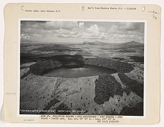
The Jolo Group of Volcanoes, more commonly referred to as the Jolo Group, are an active group of volcanoes in the island of Jolo in Southern Philippines. The Global Volcanism Program lists Jolo as one of the active volcanoes in the Philippines while the Philippine Institute of Volcanology and Seismology (PHIVOLCS) collectively list the group as Bud Dajo, one of the cinder cones on the island.

Balut Island, also known as Malulong, is a potentially active volcanic island south of the tip of Davao Occidental province in the Mindanao region, southern Philippines. At the center of the island is Balut Volcano, a fumarolic volcano with no historical eruptions.

Mahagnao Volcano also known as part of is a dormant stratovolcano located in the Barangay Mahagnao part of the municipality of Burauen province of Leyte, Philippines. It is also bounded by the municipalities of La Paz and MacArthur. The area is mostly composed of wetland forests and also the birth of many rivers and streams flowing on many part of Burauen and on its neighboring towns.

References

  1. 1 2 3 4 5 6 Heaney, Lawrence R. The Mammals and birds of Camiguin Island, Philippines, a distinctive center of biodiversity. Chicago: Field Museum of Natural History. Retrieved 6 November 2015.
  2. 1 2 "Proclamation No. 570, s. 2004". Official Gazette of the Republic of the Philippines. Retrieved 6 November 2015.
  3. Villanueva, Rhodina (8 November 2015). "Mt. Hibok-Hibok named Asean heritage park". Philippine Star . Retrieved 8 November 2015.
  4. 1 2 "Volcanos – The Island Born of Fire". Camiguin Official Tourism Website. Retrieved 6 November 2015.
  5. "Hibok-Hibok Volcano Observatory". Philippine Institute of Volcanology and Seismology . Retrieved 6 November 2015.
  6. "PH 090 Timpoong and Hibok-Hibok Natural Monument". BirdLife International . Retrieved 6 November 2015.