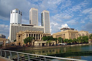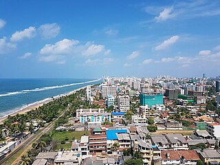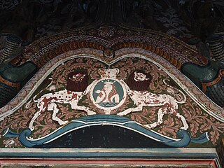
Colombo is the executive and judicial capital and largest city of Sri Lanka by population. According to the Brookings Institution, the Colombo metropolitan area has a population of 5.6 million, and 752,993 in the Municipality. It is the financial centre of the island and a tourist destination. It is located on the west coast of the island and adjacent to the Greater Colombo area which includes Sri Jayawardenepura Kotte, the legislative capital of Sri Lanka, and Dehiwala-Mount Lavinia. Colombo is often referred to as the capital since Sri Jayawardenepura Kotte is itself within the urban/suburban area of Colombo. It is also the administrative capital of the Western Province and the district capital of Colombo District. Colombo is a busy and vibrant city with a mixture of modern life, colonial buildings and monuments.

The Western Province is one of the nine provinces of Sri Lanka, the first level administrative division of the country. The provinces have existed since the 19th century but did not have any legal status until 1987 when the 13th Amendment to the Constitution of Sri Lanka established provincial councils. Western Province is the most densely populated province in the country and is home to the legislative capital Sri Jayawardenepura Kotte as well as to Colombo, the nation's administrative and business center.

Sri Jayewardenepura Kotte, commonly known as Kotte, is the legislative capital of Sri Lanka. Sri Jayawardenepura Kotte is located adjacent to the urban area of Sri Lanka's de facto economic, executive, and judicial capital, Colombo.

Nugegoda is a large, densely populated suburb of Colombo, Sri Lanka. It is located in the border of Sri Jayawardenapura Municipal Council limits and Dehiwela Mt. Lavinia Municipal Council limits, just outside Colombo city limits. It has a population of roughly over 250,000 people

Dehiwala-Mount Lavinia, population 245,974 (2012), is a large municipality in Sri Lanka, covering 2,109 ha. It lies south of the Colombo Municipal Council area and is separated from it by the Dehiwala canal which forms the northern boundary of DMMC. Its southern limits lie in Borupana Road and the eastern boundary is Weras Ganga with its canal system and it includes some areas to its east. This town has experienced extensive population growth and rapid industrialisation and urbanisation in recent years. It is home to Sri Lanka's National Zoological Gardens, which remains one of Asia's largest. Colombo South Teaching Hospital, Kalubowila and Colombo Airport, Ratmalana are some important landmarks in this area. Dehiwela-Mount Lavinia and Sri Jayawardenapura Kotte being two large suburban centres of the city of Colombo function together as one large urban agglomeration in the Region. The overspill from the City in residential and commercial uses of land has rapidly urbanised these suburban centres. Dehiwela-Mount Lavinia and Sri Jayawardenpaura along with Colombo Municipal Council form the most urbanised part of the core area of the Colombo Metropolitan Region. Dehiwala and Mount Lavinia lie along the Galle Road artery, which runs along the coast to the south of the country.

Battaramulla is situated 8.4 km (5 mi) from the Colombo Fort, near the Parliament of Sri Lanka. It is one of the fastest developing administrative, commercial and residential areas in the Colombo District, being home to the country's elite. Battaramulla is an important town in Sri Lanka, because of the Sri Lankan government's decision to locate all the government department head offices in this town.
Rajagiriya is a part of the Sri Lanka's administrative capital of Sri Jayawardenapura. A fairly large suburb bordering Colombo, Rajagiriya lies between Borella and Ethul Kotte, straddling Parliament Road.
Maharagama is an outer suburb of Colombo, Sri Lanka on the High-Level (A4) Road about 10 km (6.2 mi) from the centre of the commercial capital. It developed rapidly in the 1980s as a dormitory suburb. Governed by the Maharagama Urban Council, the town possesses facilities like supermarkets, department stores, clothing, food and beverages shops to fulfill the needs of citizens.
Thalawathugoda is a vicinity of Maharagama governed by the Urban Council of Maharagama. It is located approximately 16 km (9.9 mi) from the centre of Colombo, adjacent to Battaramulla and Pelawatte on the Borella-Kottawa Road, bordering Sri Jayawardenapura-Kotte. The Diyawanna Oya forms the "Sri Jayawardenapura-Kotte" boundary of Thalawathugoda.
Seeduwa is a suburb of Negombo, in Katana Divisional Secretariat, Western Province of Sri Lanka. It is located on the A03 road between Colombo and Negombo.
The Sri Lankan Parliament Complex is a public building and landmark that houses the Parliament of Sri Lanka. Situated in Sri Jayawardenepura Kotte, the administrative capital, it is built on an island, surrounded by the Diyawanna Oya. It was designed by Deshamanya Geoffrey Bawa.
Sellapperumage Saman Piyasiri Fernando, was the military wing leader of the Janatha Vimukthi Peramuna during the 1987-89 insurrection in Sri Lanka, the JVP's military wing also known as Deshapremi Janatha Viyaparaya (DJV). His position in the JVP as the military commander was organizationally higher than the position of Rohana Wijeweera, the founder of the JVP.
Dandugama is a village in Sri Lanka. It is own for Ja-Ela polling division at Gampaha District at Western Province, Sri Lanka.

The Sri Jayawardenepura Kotte Municipal Council is the local council for Sri Jayawardenepura Kotte, the administrative capital city of Sri Lanka. The council was first formed as Kotte Urban Development Council which was established in the 1930s and the council became Sri Jayawardenepura Kotte Municipal Council in 1997, Chandra Silva was elected as the first mayor.

Pagoda East Grama Niladhari Division is a Grama Niladhari Division of the Sri Jayawardanapura Kotte Divisional Secretariat of Colombo District of Western Province, Sri Lanka. It has Grama Niladhari Division Code 519C.

Gothamipura Grama Niladhari Division is a Grama Niladhari Division of the Thimbirigasyaya Divisional Secretariat of Colombo District of Western Province, Sri Lanka.
Pagoda Grama Niladhari Division is a Grama Niladhari Division of the Sri Jayawardanapura Kotte Divisional Secretariat of Colombo District of Western Province, Sri Lanka. It has Grama Niladhari Division Code 519A.

Welikada North Grama Niladhari Division is a Grama Niladhari Division of the Sri Jayawardanapura Kotte Divisional Secretariat of Colombo District of Western Province, Sri Lanka. It has Grama Niladhari Division Code 514D.

Nawala West Grama Niladhari Division is a Grama Niladhari Division of the Sri Jayawardanapura Kotte Divisional Secretariat of Colombo District of Western Province, Sri Lanka. It has Grama Niladhari Division Code 520.

Kolonnawa Urban Council is the local authority for Kolonnawa and surrounding suburbs in Sri Lanka. It has 20 members elected under the mixed electoral system where 60% of members are elected using first-past-the-post voting and the remaining 40% through closed list proportional representation.


