
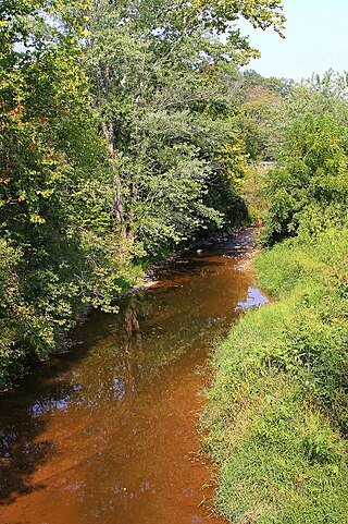
Mahanoy Creek is a 51.6-mile-long (83.0 km) tributary of the Susquehanna River in Northumberland and Schuylkill counties, Pennsylvania. There are at least 35 sources of acid mine drainage in the creek's watershed. Anthracite was mined in the upper part of the Mahanoy Creek watershed in the 19th and 20th centuries. Mahanoy Creek's tributaries include Schwaben Creek, Zerbe Run, Little Mahanoy Creek, Shenandoah Creek, and North Mahanoy Creek. Little Mahanoy Creek and Schwaben Creek are two streams in the watershed that are unaffected by acid mine drainage. Schwaben Creek has a higher number and diversity of fish species than the main stem.
Schwaben Creek is a tributary of Mahanoy Creek in Northumberland County, Pennsylvania, in the United States. Schwaben Creek is approximately 12.4 miles (20.0 km) long. The creek has two named tributaries, which both join Schwaben Creek fairly close to its mouth. The tributaries are called Middle Creek and Mouse Creek. Schwaben Creek flows through Upper Mahanoy Township, Washington Township, and Jackson Township. Nearly all of the creek's watershed is devoted to agricultural land and forests, although there is some development. Painted furniture was also made in the Schwaben Creek valley in the 18th and 19th centuries. The creek is in the ridge-and-valley geographical province.
Scotch Run is one of the main tributaries of Catawissa Creek in Columbia County, Pennsylvania, in the United States. It is approximately 7.8 miles (12.6 km) long and flows through Beaver Township and Main Township. The stream's watershed has an area of 9.10 square miles (23.6 km2). The stream is infertile and acidic. It is 7.2 feet (2.2 m) wide in its upper reaches and 17.0 feet (5.2 m) wide in its lower reaches. The main rock formations in the watershed include the Mauch Chunk Formation, the Pocono Formation, the Pottsville Formation, and the Spechty Kopf Formation. The main soils include Leck Kill soil and Hazleton soil. It flows between Nescopeck Mountain and McCauley Mountain.

Furnace Run is a tributary of Catawissa Creek in Columbia County, Pennsylvania, in the United States. It is approximately 2.5 miles (4.0 km) long and flows through Catawissa Township and Main Township. The stream is the last named tributary to enter Catawissa Creek before its mouth. The stream's watershed has an area of 2.82 square miles (7.3 km2). The main rock formations are the Pottsville Group and the Mauch Chunk Formation. The stream itself is considered to be a high quality coldwater fishery and Class A Wild Trout Waters.

Fisher Run is a tributary of Catawissa Creek in Columbia County, Pennsylvania, in the United States. It is approximately 2.9 miles (4.7 km) long and flows through Main Township and Beaver Township. The stream is impaired by acid mine drainage. It is considered to be a high-quality coldwater fishery and Class A Wild Trout Waters. The watershed of the stream has an area of 3.03 square miles (7.8 km2).

Long Hollow is a tributary of Catawissa Creek in Columbia County, Pennsylvania, in the United States. It is approximately 2.5 miles (4.0 km) long and flows through Roaring Creek Township and Beaver Township. The watershed of the stream has an area of 2.84 square miles (7.4 km2). The stream has a neutral pH and is considered to be a coldwater fishery. The main rock formations in the stream's watershed are the Mauch Chunk Formation, the Spechty Kopf Formation, the Pocono Formation, and the Buddys Run Member of the Catskill Formation.
Klingermans Run is a tributary of Catawissa Creek in Columbia County, Pennsylvania, in the United States. It is approximately 2.4 miles (3.9 km) long and flows through Roaring Creek Township and Beaver Township. The watershed of the stream has an area of 1.78 square miles (4.6 km2). The stream is considered to be a High-Quality Coldwater Fishery and Class A Wild Trout Waters. The main rock formations in the stream's watershed are the Mauch Chunk Formation and the Pocono Formation and the main soils are the Leck Kill soil and the Hazleton soil.

Cranberry Run is a tributary of Catawissa Creek in Columbia County, Pennsylvania, in the United States. It is approximately 2.0 miles (3.2 km) long and flows through Beaver Township. The watershed of the stream has an area of 1.83 square miles (4.7 km2). The stream is considered to be a Coldwater Fishery. The main rock formations in the stream's watershed are the Mauch Chunk Formation and the Pocono Formation and the main soils are the Leck Kill soil and the Hazleton soil.
Crooked Run is a tributary of Catawissa Creek in Schuylkill County, Pennsylvania, in the United States. It is approximately 4.4 miles (7.1 km) long and flows through North Union Township. The watershed of the stream has an area of 4.24 square miles (11.0 km2). The stream is considered to be a High-Quality Coldwater Fishery and Class A Wild Trout Waters. However, it is impaired by atmospheric deposition. The main rock formations in the stream's watershed are the Mauch Chunk Formation and the Pocono Formation and the main soils are the Leck Kill soil and the Hazleton soil.

Raccoon Creek is a tributary of Tomhicken Creek in Luzerne County and Schuylkill County, in Pennsylvania, in the United States. It is approximately 3.3 miles (5.3 km) long and flows through Black Creek Township in Luzerne County and North Union Township in Schuylkill County. The watershed of the stream has an area of 2.67 square miles (6.9 km2). The stream is considered to be a High-Quality Coldwater Fishery and Class A Wild Trout Waters. The main rock formations in the stream's watershed are the Mauch Chunk Formation and the Pottsville Formation and the main soil is the Leck Kill soil.

Little Crooked Run is a tributary of Tomhicken Creek in Schuylkill County, Pennsylvania, in the United States. It is approximately 1.7 miles (2.7 km) long and flows through North Union Township. The watershed of the stream has an area of 1.22 square miles (3.2 km2). The stream is considered to be a High-Quality Coldwater Fishery and Class A Wild Trout Waters. The main rock formations in the stream's watershed are the Mauch Chunk Formation and the Pottsville Formation and the main soil is the Hazleton soil.

Little Catawissa Creek is a tributary of Catawissa Creek in Columbia County and Schuylkill County, in Pennsylvania, in the United States. It is approximately 10.8 miles (17.4 km) long and flows through Conyngham Township in Columbia County and Union Township and North Union Township in Schuylkill County. The named tributaries of the creek include Stony Run and Trexler Run. The creek has some alkalinity and is slightly acidic. The main rock formations in the watershed of it are the Mauch Chunk Formation, the Pocono Formation, and the Pottsville Formation. A number of other rock formations occur in small areas of the watershed as well. The main soils in the watershed are the Leck Kill soil and the Hazleton soil.

Trexler Run is a tributary of Little Catawissa Creek in Columbia and Schuylkill counties in Pennsylvania, in the United States. It is approximately 3.4 miles (5.5 km) long and flows through Roaring Creek Township in Columbia County and Union Township in Schuylkill County. The watershed of the stream has an area of 3.81 square miles (9.9 km2). The stream is considered to be a High-Quality Coldwater Fishery and Class A Wild Trout Waters. The main rock formations in the stream's watershed are the Mauch Chunk Formation, the Pocono Formation, and the Pottsville Formation and the main soil is the Leck Kill soil. Both brook trout and brown trout inhabit the stream, as do several other species of fish.

Dark Run is a tributary of Catawissa Creek in Schuylkill County, Pennsylvania, in the United States. It is approximately 4.3 miles (6.9 km) long and flows through Union Township. The watershed of the stream has an area of 4.55 square miles (11.8 km2). The stream is considered to be a High-Quality Coldwater Fishery and Class D Wild Trout Waters. Eight species of fish inhabit the stream. The main rock formations in the stream's watershed are the Mauch Chunk Formation and the main soil is the Leck Kill soil. The stream has several unnamed tributaries.

Rattling Run is a tributary of Catawissa Creek in Schuylkill County, Pennsylvania, in the United States. It is approximately 2.4 miles (3.9 km) long and flows through East Union Township. The watershed of the stream has an area of 2.28 square miles (5.9 km2). The stream is considered to be a High-Quality Coldwater Fishery and Class A Wild Trout Waters. Three species of fish inhabit the stream. The main rock formations in the stream's watershed are the Mauch Chunk Formation and the Pottsville Formation and the main soils are the Leck Kill soil and the Hezleton soil. The stream has two unnamed tributaries.

Davis Run is a tributary of Catawissa Creek in Schuylkill County, Pennsylvania, in the United States. It is approximately 1.2 miles (1.9 km) long. The watershed of the stream has an area of 2.86 square miles (7.4 km2). The stream is considered to be a High-Quality Coldwater Fishery and Class A Wild Trout Waters. Six species of fish inhabit the stream, including brown trout and brook trout. The main rock formations in the stream's watershed are the Mauch Chunk Formation and the Pottsville Formation and the main soils are the Leck Kill soil and the Hezleton soil. The stream has two unnamed tributaries and a lake known as the Pumping Station Reservoir.

Messers Run is a tributary of Catawissa Creek in Schuylkill County, Pennsylvania, in the United States. It is approximately 5.2 miles (8.4 km) long and flows through Kline Township and East Union Township. The only named tributary of the stream is Negro Hollow, but it has two unnamed tributaries. The creek has some alkalinity, but is slightly acidic. The main rock formations in the watershed of it are the Mauch Chunk Formation and the Pottsville Formation. The main soils in the watershed are the Leck Kill soil and the Hazleton soil.
Fall Brook is a tributary of the Lackawanna River in Susquehanna County and Lackawanna County, Pennsylvania, in the United States. It is approximately 7.9 miles (12.7 km) long and flows through Clifford Township in Susquehanna County and Fell Township, Carbondale Township, and Carbondale in Lackawanna County. The watershed of the stream has an area of 12.4 square miles (32 km2), making it one of the largest tributaries of the Lackwanna River. It is not designated as impaired, but does experience flow loss. The stream begins on the Allegheny Plateau and passes through the Fall Brook Gap. It also flows over the Fall Brook Falls, which are 60 feet (18 m) high. Fall Brook is situated within the Coal Region.

North Mahanoy Creek is a tributary of Mahanoy Creek in Schuylkill County, Pennsylvania. It is approximately 4.4 miles (7.1 km) long and flows through Delano Township, Mahanoy Township, and Mahanoy City. The watershed of the creek has an area of 5.99 square miles (15.5 km2). The creek is designated as an impaired waterbody due to sedimentation/siltation and water/flow variation from abandoned mine drainage. The creek is relatively small, an ephemeral stream in its lower reaches, and is located within the Western Middle Anthracite Field.
Little Mahantango Creek is a tributary of Mahantango Creek in Schuylkill County and Northumberland County, in Pennsylvania, in the United States. It is approximately 9.6 miles (15.4 km) long and flows through Eldred Township and Upper Mahantongo Township in Schuylkill County and Upper Mahanoy Township in Northumberland County. The watershed of the creek has an area of 15.1 square miles (39 km2). The creek has many unnamed tributaries and sub-tributaries; all of them, as well as the main stem, are impaired. The cause of impairment in Little Mahantango Creek is sedimentation/siltation and the probable source of impairment is agriculture.

