Nesco, New Jersey | |
|---|---|
 CR 542 westbound in Nesco | |
| Coordinates: 39°38′17″N74°41′48″W / 39.63806°N 74.69667°W | |
| Country | |
| State | |
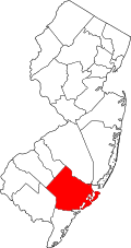
| County | Atlantic |
| Township | Mullica |
| Area | |
• Total | 2.64 sq mi (6.84 km2) |
| • Land | 2.64 sq mi (6.84 km2) |
| • Water | 0 sq mi (0.00 km2) |
| Elevation | 46 ft (14 m) |
| Population | |
• Total | 422 |
| • Density | 160/sq mi (61.7/km2) |
| Time zone | UTC−05:00 (Eastern (EST)) |
| • Summer (DST) | UTC−04:00 (EDT) |
| FIPS code | 34-50010 [4] |
| GNIS feature ID | 878708 [2] |


Nesco (also called New Columbia) is an unincorporated community and census-designated place (CDP) [5] located in Mullica Township, Atlantic County, in the U.S. state of New Jersey. [6] [2] [7]
Contents
Nesco is located approximately 6 mi (9.7 km) east of Hammonton.
The New Columbia-Nesco United Methodist Church is located there. [8] The Nesco School is located west of the settlement. [9]