Related Research Articles
Winston is a former census-designated place (CDP) in Polk County, Florida, United States. The population was 9,024 at the 2000 census. Most of the community's core is now part of neighboring Lakeland. It is part of the Lakeland–Winter Haven Metropolitan Statistical Area.

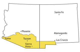
Chaparral is an unincorporated community and census-designated place (CDP) in Doña Ana and Otero counties, New Mexico. The population was 14,631 at the 2010 census. Chaparral is primarily a bedroom community for the neighboring city of El Paso, Texas, and the neighboring military installations of White Sands Missile Range and Fort Bliss. It is officially part of the Las Cruces Metropolitan Statistical Area.

Casper Mountain is a census-designated place (CDP) on Casper Mountain in Natrona County, Wyoming, United States. It is part of the Casper, Wyoming Metropolitan Statistical Area. The population was 401 at the 2010 census.
The Gadsden Purchase is a 29,640-square-mile (76,800 km2) region of present-day southern Arizona and southwestern New Mexico that the United States acquired from Mexico by the Treaty of Mesilla, which took effect on June 8, 1854. The purchase included lands south of the Gila River and west of the Rio Grande where the U.S. wanted to build a transcontinental railroad along a deep southern route, which the Southern Pacific Railroad later completed in 1881–1883. The purchase also aimed to resolve other border issues.

The Adams–Onís Treaty of 1819, also known as the Transcontinental Treaty, the Spanish Cession, the Florida Purchase Treaty, or the Florida Treaty, was a treaty between the United States and Spain in 1819 that ceded Florida to the U.S. and defined the boundary between the U.S. and Mexico. It settled a standing border dispute between the two countries and was considered a triumph of American diplomacy. It came during the successful Spanish American wars of independence against Spain.
Newman is a small El Paso neighborhood in far Northeast El Paso, located some 16 miles northeast of downtown El Paso around the intersection of Dyer Street and Edge of Texas Drive on the New Mexico state line, and still sometimes described as a separate community. In 1990, it had a population of approximately 60 people.

The Territory of New Mexico was an organized incorporated territory of the United States from September 9, 1850, until January 6, 1912. It was created from the U.S. provisional government of New Mexico, as a result of Nuevo México becoming part of the American frontier after the Treaty of Guadalupe Hidalgo. It existed with varying boundaries until the territory was admitted to the Union as the U.S. state of New Mexico in 1912. This jurisdiction was an organized, incorporated territory of the US for nearly 62 years, the longest period of any territory in the contiguous United States.

The Tularosa Basin is a graben basin in the Basin and Range Province and within the Chihuahuan Desert, east of the Rio Grande in southern New Mexico and West Texas, in the Southwestern United States.

East El Paso is an area of El Paso, Texas, United States, that is located north of Interstate 10, east of Airway Blvd., and south of Montana Ave. East El Paso is the fastest growing area of town. With a population of over 150,000, east El Paso is also the largest area of town. Its neighborhoods are mainly middle-class, but east El Paso does have a considerable number of affluent neighborhoods. East El Paso is noted also for its ridges and cliffs which offer desirable views of the Lower Valley, Ciudad Juárez, the Franklin Mountains, and Downtown El Paso. It also possesses the greatest number of entertainment venues in the city.

The Robledo Mountains are a mountain range in Doña Ana County, New Mexico, just northwest of Las Cruces. They are an uplifted block of Paleozoic rocks on the west side of the Rio Grande Rift.

The Brazos Mountains is a range in far northern Rio Arriba County, in northern New Mexico in the southwestern United States. The range is part of the Tusas Mountains, which extended slightly into Colorado. A high crest runs from the border with Colorado for over 20 miles (32 km) in a south-southeasterly direction. The high point of the range at 11,405 feet (3,476 m) is on Grouse Mesa, at the Brazos Benchmark. Two miles (3 km) to the southeast is the more distinctive Brazos Peak, at 11,288 feet.
The United States Border Patrol operates 71 traffic checkpoints, including 33 permanent traffic checkpoints, near the Mexico–United States border. The stated primary purpose of these inspection stations is to deter illegal immigration and smuggling activities. After the September 11 attacks in 2001, they took on the additional role of terrorism deterrence. These checkpoints are located between 25 and 75 miles of the Mexico–United States border along major U.S. highways; near the southern border of the contiguous United States. Their situation at interior locations allow them to deter illegal activities that may have bypassed official border crossings along the frontier. The checkpoints are divided among nine Border Patrol sectors. There are a number of these checkpoints near the northern border of the contiguous U.S. as well, within 100 miles (160 km) of the Canada–U.S. border.
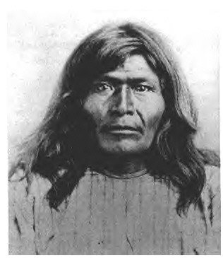
Victorio's War, or the Victorio Campaign, was an armed conflict between the Apache followers of Chief Victorio, the United States, and Mexico beginning in September 1879. Faced with arrest and forcible relocation from his homeland in New Mexico to San Carlos Indian Reservation in southeastern Arizona, Victorio led a guerrilla war across southern New Mexico, west Texas and northern Mexico. Victorio fought many battles and skirmishes with the United States Army and raided several settlements until the Mexican Army killed him and most of his warriors in October 1880 in the Battle of Tres Castillos. After Victorio's death, his lieutenant Nana led a raid in 1881.
Adrian is an unincorporated community on W County Road 59 in Big Spring township, in southwestern Seneca County, Ohio, United States, roughly three miles south-southeast of Frenchtown.
WMMH is a radio station broadcasting a Religious (Catholic) format licensed to Houtzdale, Pennsylvania, United States. The station serves the Altoona, Pennsylvania area, and is owned by J.M.J. Radio, Inc.
McCoy is an unincorporated community in Decatur County, Indiana, in the United States.
Burr Oak is an unincorporated community in Noble Township, Noble County, in the U.S. state of Indiana.
Horsethief Canyon, is a canyon comprising the upper part of the Summit Valley in San Bernardino County, California. Its head lies at 34°19′33″N117°25′38″W at an elevation of 3,800 feet just east of the summit of Cajon Pass, and its mouth at an elevation of 3,123 feet / 952 meters. California State Routes 138 and 173 pass through it.
Adobe Ranch also known as Adobe, is a locale in Socorro County, New Mexico, United States. It lies at an elevation of 5,915 feet.
References
Municipalities and communities of Otero County, New Mexico, United States | ||
|---|---|---|
| City |  | |
| Villages | ||
| CDPs | ||
| Other unincorporated communities | ||
| Indian reservation | ||
| Footnotes | ‡This populated place also has portions in an adjacent county or counties | |
32°00′12″N106°19′23″W / 32.00333°N 106.32306°W
| | This New Mexico state location article is a stub. You can help Wikipedia by expanding it. |