
Scott County is a county located in the U.S. state of Tennessee. As of the 2020 census, its population was 22,039, down from 22,228 at the 2010 census. Its county seat is Huntsville and the largest town is Oneida. Scott County is known for having seceded from Tennessee in protest of the state's decision to join the Confederacy during the Civil War, and subsequently forming The Free and Independent State of Scott.

Sierra County is a county located in the U.S. state of New Mexico. As of the 2020 Census, the population was 11,576. Its county seat is Truth or Consequences.

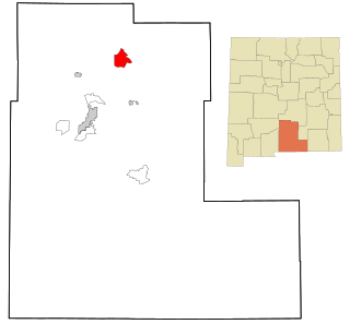
Otero County is a county located in the U.S. state of New Mexico. As of the 2020 census, the population was 67,839. Its county seat is Alamogordo. Its southern boundary is the Texas state line. It is named for Miguel Antonio Otero, the territorial governor when the county was created.

Lincoln County is a county in the U.S. state of New Mexico. As of the 2020 census, the population was 20,269. Its county seat is Carrizozo, while its largest community is Ruidoso.

Eddy County is a county located in the U.S. state of New Mexico. As of the 2020 census, the population was 62,314. Its county seat and largest city is Carlsbad. The county was created in 1891 and later organized in 1892. It is north of the Texas state line.

Chaves County is a county in New Mexico, United States. As of the 2020 census, the population was 65,157. Its county seat is Roswell. Chaves County was named for Colonel Jose Francisco Chaves, a military leader there during the Civil War and later in Navajo campaigns. The county was created by the New Mexico Territorial Legislature on February 25, 1889, out of land from Lincoln County.

Chaparral is an unincorporated community and census-designated place (CDP) in Doña Ana and Otero counties, New Mexico. The population was 14,631 at the 2010 census. Chaparral is primarily a bedroom community for the neighboring city of El Paso, Texas, and the neighboring military installations of White Sands Missile Range and Fort Bliss. It is officially part of the Las Cruces Metropolitan Statistical Area.

Brimhall Nizhoni is a census-designated place (CDP) in McKinley County, New Mexico, United States. The population was 199 at the 2010 census. The Navajo Coyote Canyon Chapter House is located in Brimhall.

Twin Lakes is a census-designated place (CDP) in McKinley County, New Mexico, United States. The population was 1,069 at the 2000 census.

Boles Acres is a census-designated place (CDP) in Otero County, New Mexico, United States. The population was 1,638 at the 2010 census.
Mescalero is a census-designated place (CDP) in Otero County, New Mexico, United States, located on the Mescalero Apache Reservation. The population was 1,338 at the 2010 census.

Timberon is a census-designated place (CDP) in Otero County, New Mexico, United States, and is within the Sacramento Mountains at the southern edge of the Lincoln National Forest. The population was 345 at the 2020 census.

La Cienega is a census-designated place (CDP) in Santa Fe County, New Mexico, United States. It is part of the Santa Fe, New Mexico, metropolitan statistical area. The population was 3,007 at the 2000 census.

Los Lunas is a village in Valencia County, New Mexico, United States. As of the 2010 census, the village population is 14,835 inside the village limits due to the new housing developments at El Cerro de Los Lunas. It is the county seat of Valencia County. Los Lunas is part of the Albuquerque Metropolitan Statistical Area.
Orogrande is an unincorporated community in Otero County, New Mexico, United States, located in the Jarilla Mountains of the Tularosa Basin on U.S. 54 between El Paso, Texas and Alamogordo. The community had a population of 52 in the 2010 census.

Doña Ana County is a county located in the southern part of the State of New Mexico, United States. As of the 2020 U.S. Census, its population was 219,561, which makes it the second-most populated county in New Mexico. Its county seat is Las Cruces, the second-most populous municipality in New Mexico after Albuquerque, with 111,385 as of the 2020 U.S. Census.
Weed is a hamlet and a census-designated place in Otero County, New Mexico, United States. It lies alongside New Mexico State Road 24 on the southeastern slopes of the Sacramento Mountains at an elevation of 7,215 ft. It has had a Post Office since 1885. As of the 2010 census, its population was 63.
Bent is a census-designated place in Otero County, New Mexico, United States. Its population was 119 as of the 2010 census. Bent has a post office with ZIP code 88314. U.S. Route 70 passes through the community.

Sacramento is a census-designated place in Otero County, New Mexico, United States. Its population was 58 as of the 2010 census. Sacramento has a post office with ZIP code 88347. New Mexico State Road 521 passes through the community.
Crestview is a census-designated place (CDP) in McKinley County, New Mexico, United States. It was first listed as a CDP prior to the 2020 census.

