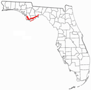
Wakulla County is a county located in the Big Bend region in the northern portion of the U.S. state of Florida. As of the 2020 census, the population was 33,764. Its county seat is Crawfordville.

St. Marks is a city in Wakulla County, Florida, United States. It is part of the Tallahassee metropolitan area. The population was 293 at the 2010 census. As of 2018, the population estimated by the U.S. Census Bureau is 319.

The Florida panhandle is the northwestern part of the U.S. state of Florida. It is a salient roughly 200 miles (320 km) long, bordered by Alabama on the north and the west, Georgia on the north, and the Gulf of Mexico to the south. Its eastern boundary is arbitrarily defined. It is defined by its southern culture and rural geography relative to the rest of Florida, as well as closer cultural links to French-influenced Louisiana, Mississippi, and Alabama. Its major communities include Pensacola, Navarre, Destin, Panama City Beach, and Tallahassee.

The Lake Wimico and St. Joseph Canal and Railroad was the first steam railroad in Florida and one of the first in the U.S., opening in 1836. With the collapse of the town of St. Joseph, the railroad was abandoned by 1842.
St. Joseph was a boomtown that briefly became the largest community in Florida, United States, before being abandoned less than eight years after it was founded. St. Joseph was founded in 1835 on the shores of St. Joseph Bay. A brief period of prosperity was ended by a yellow fever epidemic in 1841, and the abandoned remnants of the town were destroyed by a storm surge in 1844. The town site is in Gulf County, Florida, near the city of Port St. Joe.

State Road 267 is a north–south state route in the eastern Florida panhandle, west of Tallahassee.

Wakulla Springs is located 14 miles (23 km) south of Tallahassee, Florida and 5 miles (8.0 km) east of Crawfordville in Wakulla County, Florida at the crossroads of State Road 61 and State Road 267. It is protected in the Edward Ball Wakulla Springs State Park.
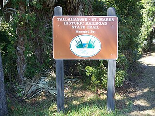
Tallahassee-St. Marks Historic Railroad State Trail is a rail trail and Florida State Park located on 16 miles (26 km) of the historic railbed of the Tallahassee Railroad, which ran between Tallahassee and St. Marks, Florida. The trail ends near the confluence of the St. Marks and Wakulla Rivers. The portion of the trail south of US 98 is designated as a portion of the Florida National Scenic Trail. A paved extension of the trail extends north for approximately 4 miles (6.4 km) into the City of Tallahassee.
St. Marks National Wildlife Refuge, in Wakulla County, Florida, is one of the oldest wildlife refuges in the United States. Established in 1931 as a wintering ground for migratory birds, it encompasses more than 83,000 acres spread between Wakulla, Jefferson, and Taylor Counties in the state of Florida.
The Tallahassee Railroad, headquartered in Tallahassee, Florida, was one of the first two railroads in Florida, starting operations in 1836 or 1837. It did not successfully use steam locomotives until 1855, with trains being pulled by mules for more than 20 years. The principal source of traffic on the railroad for many years was carrying cotton bales from Tallahassee to seaports on the St. Marks River.
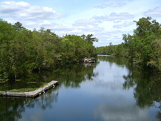
The St. Marks River is a river in the Big Bend region of Florida. It has been classified by the Florida Department of Environmental Protection as an Outstanding Florida Water, and is the easternmost river within the Northwest Florida Water Management District.
The Forgotten Coast refers to a largely untouched and uninhabited area of coastline in the panhandle of the US state of Florida. The term, also a trademark, was first used in 1992, but the Forgotten Coast's exact location is not agreed upon.
Magnolia, Florida was a thriving river port town in southern Wakulla County, Florida, established in the 1820s and is classified as an "extinct city" by the State Library and Archives of Florida. All that remains of the city is the cemetery; the last known burial was in 1859. The cemetery is on land now owned by the St. Joe Paper Company. The town was located near the small city of St. Marks, Florida.

Port Leon, Florida, was a river port town located in what is now Wakulla County, Florida. The town existed for only about six years in the first half of the 19th century. Port Leon is classified as an "extinct city" by the State Library and Archives of Florida, and only remnants can be found today.
The history of Tallahassee, Florida, much like the history of Leon County, dates back to the settlement of the Americas. Beginning in the 16th century, the region was colonized by Europeans, becoming part of Spanish Florida. In 1819, the Adams–Onís Treaty ceded Spanish Florida, including modern-day Tallahassee, to the United States. Tallahassee became a city and the state capital of Florida in 1821; the American takeover led to the settlements' rapid expansion as growing numbers of cotton plantations began to spring up nearby, increasing Tallahassees' population significantly.

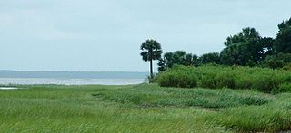
The Big Bend of Florida, United States, is an informally named geographic region of North Florida where the Florida Panhandle transitions to the Florida Peninsula south and east of Tallahassee. The region is known for its vast woodlands and marshlands and its low population density relative to much of the state. The area is home to the largest single spring in the United States, the Alapaha Rise, and the longest surveyed underwater cave in the United States, the 32-mile (51 km) Wakulla-Leon Sinks cave system.
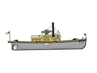
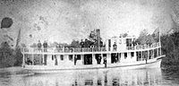
The CSS Spray was a steam-powered, side-paddle wheel tugboat built in New Albany, Indiana originally fitted as a mercantile ship before becoming a gunboat in the Confederate States Navy and used in the St. Marks, Newport, Florida area.
Daniel Ladd was born in Augusta, Maine and was an exporter, cotton broker and merchant in early Florida and active as a member of the Secession Convention of Florida.

Tropical Storm Debby was a tropical cyclone that caused extensive flooding in North Florida and Central Florida during late June 2012. The fourth tropical cyclone and named storm of the 2012 Atlantic hurricane season, Debby developed from a trough of low pressure in the central Gulf of Mexico on June 23. The formation of Debby marked the earliest formation on record of the fourth named storm within the Atlantic basin until this record was beaten by Tropical Storm Danielle in 2016. Despite a projected track toward landfall in Louisiana or Texas, the storm headed the opposite direction, moving slowly north-northeast and northeastward. The storm slowly strengthened, and at 1800 UTC on June 25, attained its peak intensity with maximum sustained winds of 65 mph (100 km/h). Dry air, westerly wind shear, and upwelling of cold waters prevented further intensification over the next 24 hours. Instead, Debby weakened, and by late on June 26, it was a minimal tropical storm. At 2100 UTC, the storm made landfall near Steinhatchee, Florida with winds of 40 mph (65 km/h). Once inland, the system continued to weaken while crossing Florida, and dissipated shortly after emerging into the Atlantic on June 27.

Hurricane Michael was a powerful and destructive tropical cyclone that became the first Category 5 hurricane to make landfall in the contiguous United States since Andrew in 1992. It was the third-most intense Atlantic hurricane to make landfall in the contiguous United States in terms of pressure, behind the 1935 Labor Day hurricane and Hurricane Camille in 1969. Michael was the first Category 5 hurricane on record to impact the Florida Panhandle, the fourth-strongest landfalling hurricane in the contiguous United States, in terms of wind speed, and the most intense hurricane on record to strike the United States in the month of October.