St. Marks Light

Last updated
St. Marks Light
Stmarkslh1867.JPG
The St. Marks Light at an unknown date.
St. Marks Light
Locationmouth of St. Marks River, on Apalachee Bay, St. Marks, Florida
Coordinates 30°04′19″N84°10′48″W / 30.07194°N 84.18000°W / 30.07194; -84.18000
Tower
Constructed1831  OOjs UI icon edit-ltr-progressive.svg
Foundationstone
Constructionbrick
Automated1960
Heightoriginally 65 feet (20 m),
extended to 73 feet (22 m) in 1867,
light is 82 feet (25 m) above sea level
Shapeconical tower
HeritageNational Register of Historic Places listed place  OOjs UI icon edit-ltr-progressive.svg
Light
First litfirst tower, 1831;
second tower, 1842
Focal height25 m (82 ft)  OOjs UI icon edit-ltr-progressive.svg
Lensfourth order Fresnel lens,
replaced by 9.8-inch (250 mm) lens
Range8 nmi (15 km; 9.2 mi)  OOjs UI icon edit-ltr-progressive.svg
Characteristic white light occulting every 4 s.
St. Marks Lighthouse
Lighthouse 1 at St Marks NWR.JPG
The lighthouse as it appeared in 2013
NRHP reference No. 72000356
Added to NRHPJuly 31, 1972

The St. Marks Light is the second-oldest light station in Florida, United States. It is located on the east side of the mouth of the St. Marks River, on Apalachee Bay. [1]

Contents

Historic background

In the 1820s, the town of St. Marks, Florida was considered an important port of entry. The town served as a port for the prosperous planting region of Middle Florida and some counties of South Georgia. Growers hauled their agricultural products down to the port town in wagons by way of an early road which connected the then territorial capital of Tallahassee to the town of St. Marks. Later, this road would be widened and improved upon by the Tallahassee Railroad and would become the state's first railroad.

Once the agricultural products reached the new port town, they were loaded aboard boats for shipment to New Orleans and/or St. Augustine. There were, however, problems in navigating both the Apalachee Bay and the St. Marks River. In many places both bay and river were shallow, and it was not too uncommon for boats to run aground and/or get mired in the muddy shallows.

Lighthouse commission

In 1828, Florida's territorial Governor William Pope Duval wrote a letter to Joseph M. White, a territorial delegate in which he stressed a great need for a lighthouse at the St. Marks location. White, in turn, wrote a letter to New Hampshire Senator Levi Woodbury, who chaired the Senate Committee on Commerce, reiterating the importance of establishing a light at St. Marks. Eleven days later, the committee issued a report which recognized the town of St. Marks as an official port of entry and recommended the building of a lighthouse in the area. On May 23, 1828, the U.S. House of Representatives passed an act which authorized the construction of a lighthouse at St. Marks and appropriated $6,000 for its construction.

Construction

After a survey was completed of the St. Marks area by Robert Mitchell, the Collector of Customs at Pensacola, and a site chosen for the lighthouse, it was discovered that the initial construction sum of $6,000 would be insufficient. The appropriation was increased to $14,000, and by mid-1829 a contract was signed with Winslow Lewis of Boston for the construction of a tower in the St. Marks area for $11,765. The finished product was not accepted by the Collector of Customs for St. Marks, Mr. Jesse H. Williams, because it had been constructed with hollow walls. Williams felt that the tower should be constructed with solid walls and, therefore, refused to accept the work.

Calvin Knowlton was brought in to rebuild the tower. He oversaw its completion, and in 1831, Williams, satisfied that the light was built according to the contract, accepted the work. That same year saw the tower's whale-oil lamps lit for the first time by Samuel Crosby, who had been appointed the first Keeper of the St. Marks Lighthouse the previous year.

Threats to the lighthouse

Second Seminole Indian War

Samuel Crosby was still Keeper of the St. Marks Lighthouse in 1835, when the Second Seminole War broke out, and soon learned of the Indian attacks on both the Cape Florida and Mosquito Inlet lighthouses. Fearing for the safety of his family, Crosby wrote authorities and requested that a small detachment of troops be quartered near his lighthouse in order to protect both it and his family against hostile attack. His request was refused. Crosby, still not satisfied with his situation, again wrote authorities and this time requested that a small boat be provided, which he could use to evacuate his family in the event of an emergency. This request was also refused. Fortunately, the Seminole Indians chose not to attack the St. Marks Lighthouse and Crosby continued in his duties as head keeper for another four years.

Natural disasters

1840 St. Marks Lighthouse U.S. Coast Guard Archive USCGStmarks1840.JPG
1840 St. Marks Lighthouse U.S. Coast Guard Archive

In 1842, erosion threatened the lighthouse and Winslow Lewis was again called in. He was given a contract to move the tower to a safer location. Lewis's contractors dismantled and removed the lantern and illuminating apparatus, then tore down the original 1829–1831 brick tower. Another site was selected farther inland, away from the water, and a new tower was constructed, then the original lantern and illuminating apparatus were reinstalled.

The new tower survived the destructive hurricanes of the 1840s and 1850s, including the disastrous hurricane of September 1843, which destroyed most of the town of Port Leon and caused major damage to the town of St. Marks.

Civil War

By the 1860s, however, a new threat to the lighthouse arose: The Civil War. In 1865, Confederate troops were stationed near the lighthouse to defend the area against a Union attack. The tower's lighting apparatus had been removed earlier in order to prevent the lighthouse from aiding ships of the Union blockade, which were patrolling the Apalachee Bay. In March of that year, a Federal fleet of 16 ships appeared off the coast and began to shell the vicinity of the lighthouse in preparation for landing a force. The Confederates attempted to blow up the lighthouse during their retreat in order to deny it as a lookout for the Union forces.

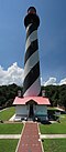
Though they were unsuccessful in destroying the tower, nevertheless, the damaged inflicted was substantial, necessitating a complete rebuild of the tower immediately following the war. During this subsequent rebuild, the tower was heightened to its present focal plane of 82 feet (25 m) above sea level, and the original lighting apparatus was restored.

Automation and deactivation

The lighthouse was automated by the United States Coast Guard in 1960, and in 2000 the Coast Guard spent $150,000 in 2000 to stabilize the lighthouse.[ citation needed ] In 2000 [2] or 2001 [3] the lighthouse's fourth-order Fresnel lens was deactivated and a modern solar-powered beacon was placed outside the lantern room. The historic Fresnel lens remained in place in the tower for over a decade. [2] In July 2005, Hurricane Dennis broke a window of the lantern, flooding the inside of the tower.[ citation needed ]

In October 2013 the Coast Guard deactivated transferred ownership of the lighthouse to the United States Fish and Wildlife Service, which operates the St. Marks National Wildlife Refuge. The lighthouse was deactivated in 2016 and the Coast Guard's solar beacon was removed. [3] Financial grants from the Florida Department of State and Duke Energy in 2016, plus crowdfunded donations, were put towards repairs and restoration. [2] On October 31, 2019, a replica of the original fourth-order Fresnel lens was lit in the tower. [4] The light is now maintained as a private aid to navigation and is lit seasonally. [3]

Related Research Articles

<span class="mw-page-title-main">Carysfort Reef Light</span> Lighthouse in Florida, US

Carysfort Reef Light is located east of Key Largo, Florida. The lighthouse has an iron-pile foundation with a platform, and a skeletal, octagonal, pyramidal tower, which is painted red. The light was 100 feet (30 m) above the water. It was the oldest functioning lighthouse of its type in the United States until it was decommissioned in 2015, having been completed in 1852. The light last installed was a xenon flashtube beacon. It was added to the National Register of Historic Places in 1984.

<span class="mw-page-title-main">Dry Tortugas Light</span> Lighthouse in Florida, United States

The Dry Tortugas Light is a lighthouse located on Loggerhead Key, three miles west of Fort Jefferson, Florida. It was taken out of operation in 2015. It has also been called the Loggerhead Lighthouse. It has been said to be "a greater distance from the mainland than any other light in the world."

<span class="mw-page-title-main">Sand Key Light</span> Lighthouse southwest of Key West, Florida, United States

Sand Key Light is a lighthouse 6 nautical miles southwest of Key West, Florida, between Sand Key Channel and Rock Key Channel, two of the channels into Key West, on a reef intermittently covered by sand. At times the key has been substantial enough to have trees, and in 1900 nine to twelve thousand terns nested on the island. At other times the island has been washed away completely.

<span class="mw-page-title-main">Key West Lighthouse</span> Lighthouse in Florida, US

The Key West Lighthouse is located in Key West, Florida. The first Key West lighthouse was a 65-foot (20 m) tower completed in 1825. It had 15 lamps in 15-inch (380 mm) reflectors.

<span class="mw-page-title-main">Egmont Key Light</span> Lighthouse in Florida, United States

The current Egmont Key Light dates from 1858. It is the oldest structure in the Tampa Bay area still used for its original purpose.

<span class="mw-page-title-main">Gasparilla Island Lights</span> Lighthouses on Gasparilla Island, Boca Grande, Florida, U.S.

The Gasparilla Island Lights are on Gasparilla Island in Boca Grande, Florida. The Port Boca Grande Lighthouse is on the southern tip of Gasparilla Island, and marked the Boca Grande Pass entrance to Charlotte Harbor.

<span class="mw-page-title-main">Ponce de Leon Inlet Light</span> Lighthouse in Florida, US

The Ponce de Leon Inlet Light is a lighthouse and museum located at Ponce de León Inlet in Central Florida. At 175 feet (53 m) in height, it is the tallest lighthouse in the state and one of the tallest in the United States. It is located between St. Augustine Light and Cape Canaveral Light. Restored by the Ponce de Leon Inlet Lighthouse Preservation Association, the lighthouse became a National Historic Landmark in 1998.

<span class="mw-page-title-main">Concord Point Light</span> Lighthouse in Maryland, United States

Concord Point Light is a 36-foot (11 m) lighthouse in Havre de Grace, Maryland. It overlooks the point where Susquehanna River flows into the Chesapeake Bay, an area of increasing navigational traffic when it was constructed in 1827. It is the northernmost lighthouse and the second-oldest tower lighthouse still standing on the bay.

<span class="mw-page-title-main">Port Sanilac Light</span> Lighthouse in Michigan, United States

Port Sanilac Light is a United States Coast Guard lighthouse located on Point Sanilac, near Port Sanilac on the eastern side of Michigan's Thumb. It is an automated and active aid to navigation on Lake Huron.

<span class="mw-page-title-main">Hog Island Light</span> Lighthouse in Virginia, United States

The Hog Island Light was a lighthouse roughly marking its eponymous island, and thus the north side of the Great Machipongo Inlet on the Virginia coast. Originally, no light existed between Cape Henlopen, Delaware and Cape Charles. In 1830 the United States Congress appropriated money for a coastal beacon in the general vicinity of Chincoteague Island. The following year, the Collector of Customs in Norfolk selected Assateague Island.

<span class="mw-page-title-main">Gay Head Light</span> Lighthouse in Massachusetts, United States

Gay Head Light is a historic lighthouse located on Martha's Vineyard westernmost point off of Lighthouse Road in Aquinnah, Massachusetts.

<span class="mw-page-title-main">Fort Sumter Range Lights</span> Lighthouses in South Carolina, US

The Fort Sumter Range Lights are range lights to guide ships through the main channel of the Charleston Harbor, South Carolina. The original front light was built at Fort Sumter and the original rear light was in the steeple of St. Philip's Church in Charleston, South Carolina. Both lights were lit from 1893 to 1915 to make range lights. Today the Fort Sumter Range is the main approach channel to Charleston Harbor.

<span class="mw-page-title-main">Whitlocks Mill Light</span> Lighthouse in Maine, US

The Whitlocks Mill Light is a lighthouse on the south bank of the St. Croix River in Calais, Maine. It is the northernmost lighthouse in the state of Maine, and was the last light to be built in the state.

<span class="mw-page-title-main">Ship Island Light</span> Lighthouse

Ship Island Light was a lighthouse in Mississippi near Gulfport.

<span class="mw-page-title-main">Heron Neck Light</span> Lighthouse in Maine, US

Heron Neck Light is a lighthouse on Green's Island in Vinalhaven, Maine at the south end of Penobscot Bay. It was established in 1854 as an aid to navigation for Vinalhaven's main port, and for the Hurricane Channel extending northwest from Heron's Neck. The light was automated in 1984. It was listed on the National Register of Historic Places as Heron Neck Light Station on January 21, 1988.

<span class="mw-page-title-main">Petit Manan Light</span> Lighthouse in Maine, US

Petit Manan Light is a lighthouse on Petit Manan Island, Maine. The island is at the end of a series of ledges extending out from Petit Manan Point, between Dyer Bay and Pigeon Hill Bay, that projects into the Gulf of Maine.

<span class="mw-page-title-main">Chandeleur Island Light</span> Lighthouse in Louisiana, US

The Chandeleur Island Light was a lighthouse established in 1848 near the northern end of the Chandeleur Islands in the Gulf of Mexico, off the east coast of Louisiana. Hurricane Katrina destroyed the light in 2005.

<span class="mw-page-title-main">Ship Shoal Light</span> Lighthouse in Louisiana, US

The Ship Shoal Light is a screw-pile lighthouse located in the Gulf of Mexico southwest of the Isles Dernieres off the coast of Louisiana. It is currently abandoned.

<span class="mw-page-title-main">Sabine Bank Light</span> Lighthouse in Texas, United States

The Sabine Bank Light is a caisson lighthouse in the Gulf of Mexico south of the mouth of the Sabine River. It is still active, though the original tower has been replaced with an automated beacon on a skeleton tower.

<span class="mw-page-title-main">Pass A L'Outre Light</span> Lighthouse in Louisiana, US

The Pass A L'Outre Light is a defunct lighthouse in the Birdfoot Delta in Louisiana, United States, located near the mouth of the Mississippi River. Erected to mark the then-active entrance to the river, it was abandoned as that channel silted up. It has been in the path of several noteworthy hurricanes, and was heavily damaged. It is on the Lighthouse Digest Doomsday List, and is critically in danger. The lighthouse is at the center of a nature preserve.

References

  1. Rowlett, Russ. "Lighthouses of the United States: Western Florida". The Lighthouse Directory. University of North Carolina at Chapel Hill.
  2. 1 2 3 "History". Friends of St. Marks Wildlife Refuge. Retrieved December 30, 2022.
  3. 1 2 3 "Historic St. Marks Lighthouse". U.S. Fish & Wildlife Service. Retrieved December 30, 2022.
  4. "Re-lighting the Light". Friends of St. Marks Wildlife Refuge. Retrieved December 30, 2022.