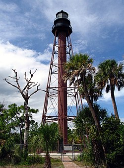
Location | Anclote Key Tarpon Springs Florida United States |
---|---|
Coordinates | 28°10′1.3″N82°50′41.0″W / 28.167028°N 82.844722°W Coordinates: 28°10′1.3″N82°50′41.0″W / 28.167028°N 82.844722°W |
Tower | |
Constructed | 1887 |
Foundation | piling |
Construction | cast iron skeletal tower |
Height | 102 feet (31 m) |
Shape | skeletal tower with central cylinder, balcony and lantern |
Markings | brown tower, black lantern |
Operator | Anclote Key Preserve State Park [1] [2] |
Heritage | National Register of Historic Places listed place |
Light | |
First lit | 2003 |
Automated | 1952 |
Deactivated | 1984-2003 |
Focal height | 110 feet (34 m) |
Lens | third-order Fresnel lens (original), replica of fourth-order Fresnel lens (current) |
Range | 19 nautical miles (35 km; 22 mi) |
Characteristic | Fl (4) W 30s. |
Anclote Key Lighthouse | |
Area | less than one acre |
Architect | US Lighthouse Service |
Architectural style | cast-iron Skeletal Structure |
NRHP reference No. | 99000410 [3] |
Added to NRHP | April 1, 1999 |
The Anclote Keys Light is a lighthouse built in 1887 on Anclote Key, the largest of the Anclote Keys. It is a skeletal square pyramidal tower, painted brown, with a black lantern. After the lighthouse was automated in 1952 the tower and other buildings at the site were often vandalized, interfering with the operation of the light. The Coast Guard determined that the light was no longer needed and deactivated it in 1984. The site was eventually turned over to the State of Florida and added to Anclote Key Preserve State Park. As of 2003 the lighthouse has been restored and relighted using a reproduction fourth-order Fresnel lens. Anclote Key is accessible only by boat. [4] [5] [6]
It is listed as Anclote Key Light number 1555 in the USCG light lists. [7]
The Stonington Harbor Light is a historic lighthouse built in 1840 and located on the east side of Stonington Harbor in the Borough of Stonington, Connecticut. It is a well-preserved example of a mid-19th century stone lighthouse. The light was taken out of service in 1889 and now serves as a local history museum. It was listed on the National Register of Historic Places in 1976.
Alligator Reef Light is located 4 nautical miles east of Indian Key, near the Matecumbe Keys of Florida in the United States, north of Alligator Reef itself. The station was established in 1873. It was automated in 1963 and was last operational in July, 2014, and is being replaced by a 16' steel structure with a less powerful light located adjacent to it. The structure is an iron pile skeleton with a platform. The light is 136 feet (41 m) above the water. It is a white octagonal pyramid skeleton framework on black pile foundation, enclosing a square dwelling and a stair-cylinder. The lantern is black. The original lens was a first order bivalve Fresnel lens. The light characteristic of the original light was: flashing white and red, every third flash red, from SW by W 1/2 W through southward to NE 1/8 E, and from NE by E 3/4 E through northward to SW 3/8 S; flashing red throughout the intervening sectors; interval between flashes 5 seconds. It had a nominal range of 14 nautical miles in the white sectors and 11 nautical miles in the red sectors. The new light has a range of approximately 7 nautical miles.
Fowey Rocks Light is located seven miles southeast of Cape Florida on Key Biscayne. The lighthouse was completed in 1878, replacing the Cape Florida Light. It was automated on May 7, 1975, and is still in operation today. The structure is cast iron, with a screw-pile foundation, a platform and a skeletal tower. The light is 110 feet above the water. The tower framework is painted brown, while the dwelling and enclosed circular stair to the lantern is painted white. The original lens was a first-order drum Fresnel lens which stood about 12 feet (4 m) high and weighed about a ton (tonne). The light has a nominal range of 15 miles in the white sectors, and 10 miles in the red sectors.
The American Shoal Light is located east of the Saddlebunch Keys, just offshore from Sugarloaf Key, close to Looe Key, in Florida, United States. It was completed in 1880, and first lit on July 15, 1880. The structure was built to the same plan and dimensions as the Fowey Rocks lighthouse, completed in 1878.
The Dry Tortugas Light is a lighthouse located on Loggerhead Key, three miles west of Fort Jefferson, Florida. It was taken out of operation in 2015. It has also been called the Loggerhead Lighthouse. It has been said to be "a greater distance from the mainland than any other light in the world."
The Garden Key Light, also known as the Tortuga Harbor Light, is located at Fort Jefferson, on Garden Key in the Dry Tortugas, Florida. The first lighthouse, started in 1824 and first lit in 1826, was a brick conical tower. The lighthouse and its outbuildings were the only structures on Garden Key until construction started on Fort Jefferson in 1846. Construction continued until 1861, but the fort was never completed.
The Amelia Island Light is the oldest existing lighthouse in the state of Florida in the United States. It is located near the northern end of Amelia Island in the northeastern part of the state. Its light marks St. Marys Entrance, the inlet leading to St. Marys River, the Cumberland Sound and the harbor of Fernandina Beach, Florida along the Amelia River. The white light flashes every ten seconds which turns red from 344° to 360° when covering the shoal water in the vicinity of Nassau Sound.
The Cape Canaveral Light is a historic lighthouse on the east coast of the U.S. state of Florida. The light was established in 1848 to warn ships of the dangerous shoals that lie off its coast. It is located inside the Cape Canaveral Space Force Station and managed by the Space Launch Delta 45 of the U.S. Space Force with the assistance of the Cape Canaveral Lighthouse Foundation. It is the only fully operational lighthouse that is owned by the United States Space Force.
The Cedar Key Light is located on Seahorse Key across the harbor from Cedar Key, Florida. Seahorse Key was the site a watchtower erected in 1801 by followers of William Augustus Bowles, self-designated Director General of the State of Muskogee, an attempt to set up an independent state in the western part of East Florida. The watchtower was destroyed by a Spanish naval force in 1802. Seahorse Key was used as a detention center for Seminoles captured in the Second Seminole War (1835–1842) before transfer to the West. At that time the Federal government reserved several of the islands in the Cedar Keys archipelago for military use.
Anclote Key Preserve State Park is a Florida State Park and historic site, located on Anclote Key three miles (5 km) off Tarpon Springs along the Atlantic coastal plain. This state park is only accessible by boat. Amenities include primitive camping on the northern portion of the island as well as picnic pavilions and grills. Wildlife includes the American oystercatcher, bald eagle and piping plover. The park is unique in that a lighthouse, built in 1887, is on the southern end of the key in Pinellas County, Florida. Three Rooker Island, south of Anclote and part of the preserve, remains an important Gulf Coast beach-nesting bird sanctuary.
The current Egmont Key Light dates from 1858. It is the oldest structure in the Tampa Bay area still used for its original purpose.
The Rebecca Shoal Light was located on a treacherous coral bank, Rebecca Shoal, 6.2 miles (10 km) west of the Marquesas Keys and 31 miles (50 km) east of the Dry Tortugas. The bank has at least a depth of 11 feet (3.4 m) and is subject to strong currents and rough seas.
The Ponce de Leon Inlet Light is a lighthouse and museum located at Ponce de León Inlet in Central Florida. At 175 feet (53 m) in height, it is the tallest lighthouse in the state and one of the tallest in the United States. It is located between St. Augustine Light and Cape Canaveral Light. Restored by the Ponce de Leon Inlet Lighthouse Preservation Association, the lighthouse became a National Historic Landmark in 1998.
The Sanibel Island Light or Point Ybel Light was one of the first lighthouses on Florida's Gulf coast north of Key West and the Dry Tortugas. The light, 98-foot above sea level, on an iron skeleton tower was first lit on August 20, 1884 and has a central spiral staircase beginning about 10 feet above the ground. It is located on the eastern tip of Sanibel Island, and was built to mark the entrance to San Carlos Bay for ships calling at the port of Punta Rassa, across San Carlos Bay from Sanibel Island. The grounds are open to the public, but the lighthouse itself is not.
Trinidad Head Lighthouse is a historic lighthouse in Trinidad, California. It is 20 miles (32 km) north of Eureka, California, built in 1871.
The Turkey Point Light is a historic lighthouse at the head of the Chesapeake Bay. Although only a 35-foot (11 m) tower, the 100-foot (30 m) height of the bluffs on which it stands makes it the third highest light off the water in the bay. It is also known for the large number of women who served as lightkeeper.
Point Sur Lighthouse is a lightstation at Point Sur 24.6 miles (39.6 km) south of Monterey, California on top the 361-foot (110 m)-tall rock at the head of the point. It was established in 1889 and is part of Point Sur State Historic Park. The light house is 40 feet (12 m) tall and 270 feet (82 m) above sea level. As of 2016, and for the foreseeable future the light is still in operation as an essential aid to navigation. Point Sur is the only complete turn-of-the-20th-century lightstation open to the public in California. Three-hour walking tours guided by volunteers are available on Wednesdays and weekends throughout the year.
Bear Island Light is a lighthouse on Bear Island near Mt. Desert Island, at the entrance to Northeast Harbor, Maine. It was first established in 1839. The present structure was built in 1889. It was deactivated in 1981 and relit as a private aid to navigation by the Friends of Acadia National Park in 1989. Bear Island Light was listed on the National Register of Historic Places as Bear Island Light Station on March 14, 1988.
Mount Desert Light is a lighthouse on Mount Desert Rock, a small island about 18 nautical miles south of Mount Desert Island, in the U.S. state of Maine. While the first light station was established in 1830, the current lighthouse was built in 1847. It was listed on the National Register of Historic Places as Mount Desert Light Station in 1988.
Wikimedia Commons has media related to Anclote Keys Light . |