Jupiter Inlet Light

Last updated
Jupiter Inlet Light
Jupiter Inlet Lighthouse.jpg
The Jupiter Inlet Lighthouse
Jupiter Inlet Light
LocationNorth side of the Jupiter Inlet in Jupiter, Florida
Coordinates 26°56′55″N80°04′55″W / 26.94861°N 80.08204°W / 26.94861; -80.08204 Coordinates: 26°56′55″N80°04′55″W / 26.94861°N 80.08204°W / 26.94861; -80.08204
Tower
Constructed1860
FoundationConcrete
ConstructionBrick
HeightTower: 105 feet (32 m), above water: 153 feet (47 m)
ShapeConical tower/cylindrical tower
HeritageNational Register of Historic Places listed place, Outstanding Natural Area   OOjs UI icon edit-ltr-progressive.svg
Light
First lit1860
Automated1928
Focal height47 m (154 ft)  OOjs UI icon edit-ltr-progressive.svg
LensFirst order Fresnel lens
Range25 nautical miles (46 km; 29 mi)
Characteristic Fixed white varied by two white flashes every 30 seconds
Jupiter Inlet Lighthouse
ArchitectJohn Nystrem
NRHP reference No. 73000597 [1]
Significant dates
Added to NRHPOctober 15, 1973
Designated ONAMay 8, 2008 [2]

The Jupiter Inlet Light is located in Jupiter, Florida, on the north side of the Jupiter Inlet. The site for the lighthouse was chosen in 1853. It is located between Cape Canaveral Light and Hillsboro Inlet Light. The lighthouse was designed by then Lieutenant George G. Meade of the Bureau of Topographical Engineers. Meade's design was subsequently modified by Lieutenant William Raynolds. The Jupiter Inlet silted shut in 1854, forcing all building supplies to be shipped in light boats down the Indian River. Work was interrupted from 1856 to 1858 by the Third Seminole War. The lighthouse was completed under the supervision of Captain Edward A. Yorke in 1860 at a cost of more than $60,000. [3]

Contents

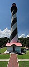
The lighthouse was built on a hill once thought to be an Indian shell mound or midden (and sometimes falsely rumored to be a burial mound), but which is now determined to be a natural parabolic sand dune. [4] The top of the 105-foot (32 m) tower is 153 feet (47 m) above sea level. The light can be seen 24 nautical miles (44 km; 28 mi) at sea. The lighthouse structure is brick with double masonry walls. The outer wall is conical, tapering from 31.5 inches (800 mm) (eight bricks thick) at ground level to 18 inches (460 mm) (three bricks thick) at base of lantern. The inner wall is cylindrical and two bricks thick throughout. Circumference at base is about 65 feet (20 m) and at the top about 43 feet (13 m). [5] The lighthouse was painted red in 1910 to cover discoloration caused by humidity. Hurricane Jeanne in 2004 sandblasted the paint from the upper portion of the tower, and the tower was repainted using a potassium silicate mineral coating.

History

The point of land which sits at the junction of the Indian River and Jupiter Inlet for thousands of years had been a meeting place for ancient Indian tribes. This strategic site did not go unnoticed by U.S. Army surveyors who in 1849 recommended the Jupiter Inlet area as a suitable place for military defenses. President Franklin Pierce signed the order to set aside a 61½-acre site on the Fort Jupiter Reservation for a lighthouse in 1854. [6]

The lighthouse was initially designed by Lieutenant George Gordon Meade. Later, Lt. William Raynolds, who succeeded Meade as head of the 4th and 7th Lighthouse Districts, improved the strength of the lighthouse with a double wall design. The lighthouse and oil house construction was accomplished by Captain Edward Yorke, who arrived December 31, 1859 and completed the tower in May 1860. It was lit July 10, 1860. [6]

A Weather Bureau station and signal station were established on the lighthouse grounds in 1889. Passing ships were signaled during the day by semaphore (flags) and at night by flares. In 1890 the Naval wireless telegraph station was established on the Reservation. It was not until 1925 that it was discovered that a mistake had been made on the original survey; the Lighthouse Reservation actually covered 113.22 acres. In 1930 the acreage was increased to 121.95 and held the tower, a keeper's house, a radio beacon, power house and several outbuildings. [6]

The U.S. Navy acquired 8.4 acres of the Reservation from the US Government and by 1936 the Navy was operating a Radio Compass Station at Jupiter as an aid to navigation. The station broadcast weather information and monitored distress signals as well as naval ship-to-shore and aircraft frequencies. On July 1, 1939 all US lighthouses became the responsibility of the U.S. Coast Guard. In the same year, the US Navy established an Intelligence Listening Post at the Naval Radio Station and constructed the barracks building for naval personnel and their families. [6]

By July 1940, the Navy's Radio Detection Finding Station, known as "Station J", came online. This secret installation was designed to intercept German U-boat radio messages and warn Allied ships and help US forces attack enemy vessels. Station J was able to pinpoint the names and locations of the submarines. In May 1943, 30 German submarines were destroyed, and in June another 37. Most had been located by the men of Station J. [6]

Jupiter Inlet Lighthouse and Museum

Lighthouse visible above the trees Jupiter Inlet FL Lighthouse02.jpg
Lighthouse visible above the trees

On January 11, 1972, the Loxahatchee River Historical Society (LRHS) was founded to preserve the area's history and it opened the Oil House Museum in June 1973. Public tours were conducted periodically by permission of the U.S. Coast Guard. On November 15, of the same year, the Lighthouse was placed on the National Register of Historic Places. By 1988 the Society had opened the Florida History Center and Museum in Burt Reynolds Park just across the inlet.

The LRHS entered into an agreement with the Coast Guard to maintain and insure the Jupiter Inlet Lighthouse and to conduct regular public tours to the top of the lighthouse for the first time in 1994. The LRHS operated a small visitor center in the east end of the last remaining building of Station J, once used as living quarters for the military.

The LRHS, with a grant from the Florida Department of Transportation and in cooperation with the Town of Jupiter and the U.S. Coast Guard, started a major restoration project in 1999 to repair weather damage to the tower. It was completed in April 2000.

In 2006, in an agreement between the LRHS, Palm Beach County, and Town of Jupiter, the old World War II building in Lighthouse Park was renovated to become the new home of the Loxahatchee River Historical Society. On December 7, 2006, the history museum and society headquarters moved from Burt Reynolds Park to Lighthouse Park to become the Jupiter Inlet Lighthouse and Museum. The LRHS also entered into a 30-year lease agreement with the U.S. Coast Guard to maintain and operate a larger portion of the land between the tower and the western fence line of the US Coast Guard property in order to set up outdoor history exhibits. Operations for the lighthouse and history museum are now in one location. [6]

The Loxahatchee River Historical Society today operates the Jupiter Inlet Lighthouse and Museum. The museum is located in Lighthouse Park, 500 Captain Armour's Way, Jupiter, Florida. Check the official website for current hours of operation. Visitors can climb the lighthouse tower and visit the History Museum by registering for admission through the gift shop.

Jupiter Inlet Lighthouse Outstanding Natural Area

U.S. Coast Guard Archive USCGJupiterinlet.jpg
U.S. Coast Guard Archive

The Jupiter Inlet Lighthouse Outstanding Natural Area (JILONA) Act was introduced into the Senate by Senator Bill Nelson and co-sponsored by Senator Mel Martinez. It was introduced into the United States House of Representatives by Congressman Tim Mahoney and co-sponsored by Congressmen Ron Klein and Alcee Hastings. This legislation designates the lighthouse and 120 surrounding acres of sensitive habitat as an Outstanding Natural Area (ONA) in the Department of the Interior, Bureau of Land Management's (BLM) National Landscape Conservation System.

The JILONA site is the first Outstanding Natural Area (ONA) in the nation east of the Pacific Coast. Two other ONAs also protect lighthouses: Yaquina Head in Oregon and Piedras Blancas Lighthouse in California. The Congressional Bill was signed by President George W. Bush on May 8, 2008, protecting this site for all Americans in perpetuity.

The JILONA is cooperatively managed by the Bureau of Land Management, and local partners: Palm Beach County, Town of Jupiter, Village of Tequesta, Loxahatchee River Historical Society, U.S. Coast Guard and Jupiter High School's Environmental Research and Field Studies Academy. Over the last decade, the group has accomplished a wealth of projects including lighthouse restoration, wetland reconstruction, river slope stabilization following hurricanes Frances and Jeanne, fuel hazard reduction and habitat improvement for endangered species, and proving the Jupiter Inlet Working Group a uniquely successful partnership. For its dedication to safeguarding Jupiter Inlet's ecological integrity and cultural heritage, the Jupiter Inlet Working Group was given the prestigious Cooperative Conservation Award from the Department of the Interior in April, 2008. [6]

Related Research Articles

Cape Hatteras Lighthouse Lighthouse in North Carolina, United States

Cape Hatteras Light is a lighthouse located on Hatteras Island in the Outer Banks in the town of Buxton, North Carolina and is part of the Cape Hatteras National Seashore. The lighthouse’s semi-unique pattern makes it easy to recognize and famous. It is often ranked high on lists of most beautiful, and famous lighthouses in the US.

Hereford Inlet Light Lighthouse

The Hereford Inlet Light is a historic lighthouse located in North Wildwood in Cape May County, New Jersey, United States, situated on the southwestern shore of Hereford Inlet at the north end of Five Mile Beach. Its construction was completed and it became operational in 1874.

Yaquina Head Light Lighthouse in Oregon

The Yaquina Head Light, also known early in its existence as the Cape Foulweather Lighthouse, is a lighthouse on the Oregon Coast of the United States. It is located in Lincoln County, near the mouth of the Yaquina River near Newport at Yaquina Head. The tower stands 93 feet (28 m) tall, and is the tallest lighthouse in Oregon.

Barnegat Lighthouse Lighthouse in New Jersey, United States

Barnegat Lighthouse or Barnegat Light, is a historic lighthouse located in Barnegat Lighthouse State Park on the northern tip of Long Beach Island, in the borough of Barnegat Light, Ocean County, New Jersey, United States, on the south side of Barnegat Inlet.

Hillsboro Inlet Light Lighthouse in Florida, United States

Hillsboro Inlet Lighthouse is a lighthouse located on the north side of Hillsboro Inlet, midway between Fort Lauderdale and Boca Raton, in Hillsboro Beach, Florida. The light marks the northern limit of the Florida Reef, an underwater coral formation on the lower east coast of the state.

Houses of Refuge in Florida 19th-century life-saving stations

The Houses of Refuge in Florida were a series of stations operated by the United States Life Saving Service along the coast of Florida to rescue and shelter ship-wrecked sailors. Five houses were constructed on the east coast in 1876, with five more added in 1885 and 1886. There were also two life-saving stations built, one just south of the Jupiter Inlet, the other on the Gulf coast on Santa Rosa Island near Pensacola, Florida. A house of refuge was planned for the Marquesas Keys, but was never put into commission. The houses were manned by civilian contractors who lived in the houses with their families. Most of these houses remained in service as life-saving stations until 1915 or later. Some of the locations became United States Coast Guard stations after the Life-Saving Service was merged with the United States Revenue Cutter Service to form the Coast Guard in 1915.

Crisp Point Light Lighthouse in Michigan, United States

Crisp Point was one of five U.S. Life-Saving Service Stations along the coast of Lake Superior between Munising and Whitefish Point in the Upper Peninsula of Michigan. The lighthouse is within McMillan Township in Luce County.

Cape Florida Light Lighthouse in Florida, US

The Cape Florida Light is a lighthouse on Cape Florida at the south end of Key Biscayne in Miami-Dade County, Florida. Constructed in 1825, it guided mariners off the Florida Reef, which starts near Key Biscayne and extends southward a few miles offshore of the Florida Keys. It was operated by staff, with interruptions, until 1878, when it was replaced by the Fowey Rocks lighthouse. The lighthouse was put back into use in 1978 by the U.S. Coast Guard to mark the Florida Channel, the deepest natural channel into Biscayne Bay. They decommissioned it in 1990.

Dry Tortugas Light Lighthouse in Florida, United States

The Dry Tortugas Light is a lighthouse located on Loggerhead Key, three miles west of Fort Jefferson, Florida. It was taken out of operation in 2015. It has also been called the Loggerhead Lighthouse. It has been said to be "a greater distance from the mainland than any other light in the world."

Amelia Island Light Lighthouse in Florida, United States

The Amelia Island Light is the oldest existing lighthouse in the state of Florida in the United States. It is located near the northern end of Amelia Island in the northeastern part of the state. Its light marks St. Marys Entrance, the inlet leading to St. Marys River, the Cumberland Sound and the harbor of Fernandina Beach, Florida along the Amelia River. The white light flashes every ten seconds which turns red from 344° to 360° when covering the shoal water in the vicinity of Nassau Sound.

Cape Canaveral Light Lighthouse in Florida, USA

The Cape Canaveral Light is a historic lighthouse on the east coast of the U.S. state of Florida. The light was established in 1848 to warn ships of the dangerous shoals that lie off its coast. It is located inside the Cape Canaveral Space Force Station and managed by the Space Launch Delta 45 of the U.S. Space Force with the assistance of the Cape Canaveral Lighthouse Foundation. It is the only fully operational lighthouse that is owned by the United States Space Force.

Sand Key Light Lighthouse southwest of Key West, Florida, United States

Sand Key Light is a lighthouse 6 nautical miles southwest of Key West, Florida, between Sand Key Channel and Rock Key Channel, two of the channels into Key West, on a reef intermittently covered by sand. At times the key has been substantial enough to have trees, and in 1900 nine to twelve thousand terns nested on the island. At other times the island has been washed away completely.

Gasparilla Island Lights Lighthouses on Gasparilla Island, Boca Grande, Florida, U.S.

The Gasparilla Island Lights are on Gasparilla Island in Boca Grande, Florida. The Port Boca Grande Lighthouse is on the southern tip of Gasparilla Island, and marked the Boca Grande Pass entrance to Charlotte Harbor.

Ponce de Leon Inlet Light Lighthouse in Florida, US

The Ponce de Leon Inlet Light is a lighthouse and museum located at Ponce de León Inlet in Central Florida. At 175 feet (53 m) in height, it is the tallest lighthouse in the state and one of the tallest in the United States. It is located between St. Augustine Light and Cape Canaveral Light. Restored by the Ponce de Leon Inlet Lighthouse Preservation Association, the lighthouse became a National Historic Landmark in 1998.

St. Augustine Light Lighthouse in Florida, US

The St. Augustine Light Station is a private-aid to navigation and an active, working lighthouse in St. Augustine, Florida. The current lighthouse stands at the north end of Anastasia Island and was built between 1871 and 1874. The tower is the second lighthouse tower in St. Augustine, the first being lit officially by the American territorial government in May 1824 as Florida's first lighthouse. However, both the Spanish and the British governments operated a major aid to navigation here including a series of wooden watch towers and beacons dating from 1565.

St. Joseph Point Light Lighthouse in Florida, US

The St. Joseph Point Light was a lighthouse on the mainland north of present-day Port St. Joe, Florida, across the entrance to St. Joseph Bay from St. Joseph Point. St. Joseph Bay is enclosed by St. Joseph Peninsula, which runs west some three miles (5 km) from the mainland to Cape San Blas, and then northerly 15 miles (24 km) to St. Joseph Point. An earlier light in the area was the St. Joseph Bay Light.

Eagle Harbor Light Lighthouse in Michigan, United States

Eagle Harbor Light is an operational lighthouse at Eagle Harbor, in Keweenaw County in the state of Michigan. It sits on the rocky entrance to Eagle Harbor and is one of several light stations that guide mariners on Lake Superior across the northern edge of the Keweenaw Peninsula. The original lighthouse, built in 1851, was replaced in 1871 by the present red brick structure, which is a Michigan State Historic Site and listed on the National Register of Historic Places.

Grindel Point Light Lighthouse in Maine, US

Grindel Point Light is a lighthouse in Islesboro, Maine, marking the west entrance to Gilkey Harbor at the westernmost point of the eponymous island. The light station was established in 1850, and the present tower and keeper's house were built in 1874. The station was deactivated in 1934 and reactivated in 1987. It was listed on the National Register of Historic Places in 1987. The keeper's house now houses the Grindel Point Sailor's Museum and the lighthouse tower is open for tours in the summer.

Little River Light Lighthouse in Maine, US

Little River Light is a lighthouse on an island at the mouth of the Little River, in Cutler, Maine. A light station was first established at this site in 1846, and the present structure was built in 1876. It is one of the only iron lighthouses in the state, and was listed on the National Register of Historic Places as Little River Light Station on March 14, 1988. The light station is now owned by the American Lighthouse Foundation, which offers overnight stays in the keeper's house, and occasional tours of the property.

Monhegan Island Light Lighthouse on Monhegan Island, Maine

Monhegan Island Light is a lighthouse on Monhegan Island, Maine. It was first established in 1824. The present structure was built in 1850. It was Alexander Parris's last significant design. It is the second highest light in Maine — Seguin Light, with a 6-foot taller tower, is 2 feet higher in elevation. It was listed on the National Register of Historic Places as Monhegan Island Lighthouse and Quarters on May 7, 1980, reference number 80000239.

References

  1. "National Register Information System". National Register of Historic Places . National Park Service. March 13, 2009. Retrieved August 19, 2016.
  2. The Consolidated Natural Resources Act of 2008 (Pub.L.   110–229 (text) (PDF), 122  Stat.   754-876, enacted May 8, 2008
  3. A Light In The Wilderness: The Story of Jupiter Inlet Lighthouse and the Southeast Florida Frontier by James D. Snyder
  4. Loxahatchee River Historical Society
  5. "Jupiter Inlet Lighthouse Facts" https://www.jupiterlighthouse.org/wp-content/uploads/2017/05/Facts-and-Timeline.pdf on September 20, 2013
  6. 1 2 3 4 5 6 7 "2013 JILM History and Description" downloaded from the Jupiter Inlet Lighthouse and Museum official website on September 20, 2013