| |
 | |
| Location | northern end of Amelia Island marking the St. Marys Entrance [1] Fernandina Beach Florida United States |
|---|---|
| Coordinates | 30°40′23.43″N81°26′32.94″W / 30.6731750°N 81.4424833°W |
| Tower | |
| Constructed | 1838-1839 |
| Foundation | stone basement |
| Construction | brick with stucco tower |
| Automated | 1970 |
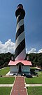
| Height | 64 feet (20 m) |
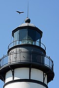
| Shape | tapered cylindrical tower with balcony and lantern |
| Markings | white tower, black lantern |
| Operator | City of Fernandina Beach [2] [3] |
| Heritage | National Register of Historic Places listed place |
| Light | |
| Focal height | 107 feet (33 m) |
| Lens | 14 lamps with 14-inch (360 mm) reflectors in a revolving lens (1839) 3rd order Fresnel lens (1903) |
| Range | white: 23 nautical miles (43 km; 26 mi) red: 19 nautical miles (35 km; 22 mi) |
| Characteristic | Fl W 10s. red from 344° to 360°, covers shoal water in vicinity of Nassau Sound. |
Amelia Island Lighthouse | |
| Location | 215 1/2 Lighthouse Circle, Fernandina Beach, Florida |
| Area | 2.4 acres (0.97 ha) |
| Architect | Lewis, Winslow |
| MPS | Florida's Historic Lighthouses MPS |
| NRHP reference No. | 03000004 [4] |
| Added to NRHP | February 13, 2003 |
The Amelia Island Light is the oldest existing lighthouse in the state of Florida in the United States. It is located near the northern end of Amelia Island in the northeastern part of the state. [5] [6] [7] Its light marks St. Marys Entrance, the inlet leading to St. Marys River, the Cumberland Sound and the harbor of Fernandina Beach, Florida along the Amelia River. [1] The white light flashes every ten seconds which turns red from 344° to 360° when covering the shoal water in the vicinity of Nassau Sound. [7]
Contents
The lighthouse is listed as number 565 in the United States Coast Guard (USCG) light list. [7]