
Lucknow district is a district located in the state of Uttar Pradesh in northern India. The city of Lucknow is the district headquarters and the district is part of Lucknow Division. It also is the capital of Uttar Pradesh Lucknow is Bounded on the east by Barabanki district, on the west by Unnao and Hardoi districts, on the south by Raebareli district and in the north by Sitapur district.
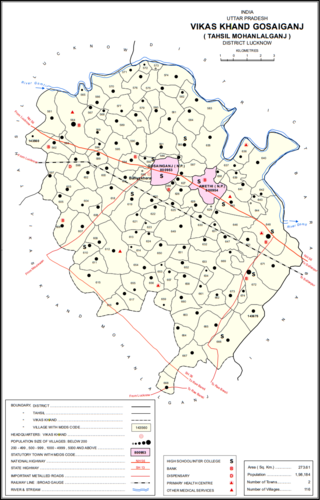
Gosainganj, also spelled Goshainganj or Gosaiganj is a town and nagar panchayat in Lucknow district of Uttar Pradesh, India. It is the seat of a community development block, which is included in the tehsil of Mohanlalganj. As of 2011, its population is 9,649, in 1,685 households. The starting point of the Purvanchal Expressway i.e. Chand Saray village is situated 2.5 km away from Gosainganj.
Bakas, also spelled Bakkas, is a village in Gosainganj block of Lucknow district, Uttar Pradesh, India. As of 2011, its population is 8,171, in 1,444 households. It is the seat of a gram panchayat.
Bahrauli is a village in Gosainganj block of Lucknow district, Uttar Pradesh, India. In 2011, its population was 5,674 in 1,092 households. It is the seat of a gram panchayat.
Bhatgaon is a village in Sarojaninagar block of Lucknow district, Uttar Pradesh, India. As of 2011, its population was 7,131, in 1,353 households. A regular market is held here. The village lands cover an area of 981.3 hectares, of which 681.9 (69.4%) were farmland in 2011. Areas under non-agricultural use covered 67.5 hectares, or 6.9% of the total village area.
Bijnaur is a village in Sarojaninagar block of Lucknow district, Uttar Pradesh, India. It was historically a major town, serving as the seat of a pargana in Lucknow tehsil. It is located east of the main road from Lucknow to Kanpur. East of Bijnaur, there is a series of jhils that make up the source of the Bakh river. As of 2011, its population was 14,105, in 2,515 households. It is the seat of a gram panchayat.
Kalyanmal is a village in Kothwan block of Hardoi district, Uttar Pradesh, India. Historically the seat of a pargana, Kalyanmal is located 11 km from the city of Beniganj, on the north side of the road leading to Atrauli and Bhatpurwaghat. Also close by is the road running from Sandila to Gundlamau in Sitapur district. Every Sunday during the month of Bhadon, a fair is held at Hattia Haran, a tank south of Kalyanmal where the god Rama is said to have bathed. Kalyanmal also hosts a small fair to Panchabgir Mahadeo during the month of Aghan. As of 2011, the population of Kalyanmal is 8,295, in 1,532 households.

Asoha is a village in Purwa tehsil of Unnao district, Uttar Pradesh, India. It is located about 16 km north of Purwa, the tehsil headquarters, and 51 km east of Unnao, the district headquarters. The main crops grown here are wheat, barley, gram, juwar, paddy, and pulses, and irrigation is provided by a canal as well as by tanks. The soil here is mostly clay. As of 2011, the population of Asoha is 3,709, in 856 households.

Gulariha is a village in Hilauli block of Unnao district, Uttar Pradesh, India. It is a dispersed settlement with several constituent hamlets, and it is right next to the border with Rae Bareli district. The Bhundi tank is located in the village, and it provides water for irrigation. As of 2011, its population is 12,482, in 2,300 households, and it has 10 primary schools and no healthcare facilities.

Panhan, also called Panhan Khas, is a small village in Purwa block of Unnao district, Uttar Pradesh, India. Located due south of Purwa and a bit to the west of the Loni River, it historically was the seat of a pargana. As of 2011, the village's population is 545 people, in 104 households.

Thulendi is a village in Bachhrawan block of Rae Bareli district, Uttar Pradesh, India. It is located 6 km from Bachhrawan, the block headquarters, on an elevated plain with clayey soil. A historic village, Thulendi served as a pargana headquarters from the early 1400s until the late 1700s, and it has several old monuments including a fort built under the Jaunpur Sultanate and two large tanks othat are said to be even older. As of 2011, Thulendi's population is 6,616, in 1,195 households.

Chandapur is a village in Maharajganj block of Rae Bareli district, Uttar Pradesh, India. Located 4 miles (6.4 km) east of Maharajganj, the block headquarters, it historically was the seat of the Kanhpuria rajas of Chandapur. In 2011, Chandapur had a population of 2,342, in 425 households. It has two primary schools and no healthcare facilities. It has a bazar known as Sheodarshanganj, which holds markets twice per week. The village also hosts the Anna Purna Devi fair on Phalguna Badi 13, which is associated with Maha Shivaratri. Vendors bring sweets, toys and everyday items to sell at the fair.

Shahmau is a village panchayat in Tiloi block of district Amethi, Uttar Pradesh, India. It is located 22 km (14 mi) from Gauriganj the district headquarters Amethi, on the road from Mohanganj to Jais. Historically, Shahmau was the taluqdari held by a branch of the Kanhpuria Kshatriya (Rajput), the Ruler taluqdars bore the hereditary title of Raja. As of 2011, its population is 1,647, in 286 households.

Brahmani is a village in Bahadurpur block of Rae Bareli district, Uttar Pradesh, India. It includes the important bazar and railway station of Fursatganj. Fursatganj holds markets twice per week, on Thursdays and Sundays, where grain, vegetables, and cloth are the main items of trade. The place also hosts a large Dussehra festival annually on Asvina Sudi 15.

Pahremau is a village in Amawan block of Rae Bareli district, Uttar Pradesh, India. Located 5 km from Maharajganj on the road to Nigohan, it is an old Muslim centre that historically served as the headquarters of a taluqdari estate. As of 2011, its population is 3,165, in 577 households. It has 3 primary schools and no healthcare facilities.
Simrauta is a village in Tiloi block of Rae Bareli district, Uttar Pradesh, India. It is located at the intersection of the Maharajganj-Inhauna and Mohanganj-Haidargarh roads, about 20 km from Maharajganj, the tehsil headquarters. Although now eclipsed by Maharajganj, Simrauta was historically a relatively important village that served as the headquarters of a pargana and the capital of a branch of the Kanhpuria Rajputs, who later became known as the Rajas of Chandapur. As of 2011, the population of Simrauta is 6,423, in 1,031 households.

Didaur, also spelled Dedaur, is a village in Sataon block of Rae Bareli district, Uttar Pradesh, India. It is located 8 km from Raebareli on the road to Unnao, just east of the intersection with the road to Lalganj. It is near the right bank of the Sai river. As of 2011, Didaur has a population of 4,781 people, in 900 households. The village hosts two annual festivals: one is the Badhwapur-ka-Mela, which is dedicated to the worship of Nag Devta and is held on Bhadra Sudi 5, and the other is the Jhurhapur-ka-Mela, which is dedicated to worship of Rama and falls on Phalguna Sudi 8.

Khiron is a village and corresponding community development block in Rae Bareli district, Uttar Pradesh, India. Located on the main Raebareli-Unnao road, Khiron is an old Muslim town that historically served as the seat of a pargana. As of 2011, the village has a population of 9,955, in 1,714 households. It has six primary schools and one medical clinic. It serves as the headquarters of a nyaya panchayat that also includes 11 other villages.

Jagatpur is a village and corresponding community development block in Unchahar tehsil of Rae Bareli district, Uttar Pradesh, India. It is located 18 km from Raebareli, the district headquarters, on the road to Allahabad at the point where it intersects the road from Dalmau to Salon. There is a large Buddhist-era ruin site at Tanghan to the south. As of 2011, Jagatpur has a population of 7,267 people, in 1,336 households. It has 4 primary schools and 1 healthcare centre.

Itaura Buzurg is a village in Rohaniya block of Rae Bareli district, Uttar Pradesh, India. One of the largest villages in the historical pargana of Salon, it is located 28 km from Raebareli, the district headquarters, near the point where the road to Allahabad intersects the one leading from Fursatganj to the Gukana ghat. As of 2011, Itaura Buzurg has a population of 13,851 people, in 2,469 households. It has 6 primary schools and no healthcare facilities.

