
Nor Lípez is a province in the Bolivian department of Potosí. Its seat is Colcha "K", also called Villa Martín. The majority of the area of the province was titled as the Nor Lípez Native Community Land on 19 April 2011. One of the largest mines of Bolivia, the San Cristóbal Mine, is located near San Cristóbal in Colcha "K" municipality.

Sur Lípez or Sud Lípez is a province in the Potosí Department in Bolivia. The seat of the province is San Pablo de Lípez.

La Mar Province is a province in the north-east corner of the Ayacucho Region, Peru. It was created on March 30, 1861.

Sucre Province is a province in the eastern part of the Ayacucho Region in Peru.

San Pablo de Lípez Municipality is the first municipal section of the Sur Lípez Province in the Potosí Department in Bolivia. Its seat is San Pablo de Lípez.
San Antonio de Esmoruco is the third municipal section of the Sur Lípez Province in the Potosí Department in Bolivia. Its seat is San Antonio de Esmoruco.
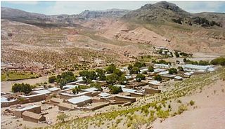
Colcha "K" Municipality is the first municipal section of the Nor Lípez Province in the Potosí Department in Bolivia. Its seat is Colcha "K" or Villa Martín.

San Pedro de Quemes is the second municipal section of the Nor Lípez Province in the Potosí Department in Bolivia. Its seat is San Pedro de Quemes.
Q'illu Urqu may refer to:

Wanaku is a mountain in the Andes of Bolivia, about 4,700 metres (15,420 ft) high. It is situated in the Potosí Department, Nor Lípez Province, Quemes Municipality, Pelcoya Canton. Wanaku lies southeast of the Ollagüe (Ullawi) volcano and northeast of Ch'aska Urqu.

Ch'aska Urqu is a mountain in the Andes of Bolivia, about 4,100 metres (13,451 ft) high. It is located in the Potosí Department, Nor Lípez Province, Quemes Municipality, Pelcoya Canton. Ch'aska Urqu lies near the border with Chile, southeast of the Ollagüe (Ullawi) volcano and southwest of Wanaku.
Yuraq Urqu is a 4,504-metre-high (14,777 ft) mountain in the Andes of Bolivia. It is situated in the Potosí Department, Sud Lípez Province, San Pablo de Lípez Municipality, southwest of San Pablo de Lípez. Yuraq Urqu lies between the Qullpa Mayu in the north and the Yana Mayu in the south, north of Yana Urqu.
Yana Urqu is a 4,623-metre-high (15,167 ft) mountain in the Andes of Bolivia. It is located in the Potosí Department, Sud Lípez Province, San Pablo de Lípez Municipality, south-west of San Pablo de Lípez. Yana Urqu lies between the little rivers Yana Mayu in the north and Ñañu Mayu in the south. It is situated south of the peak of Yuraq Urqu.
P'aqu Urqu is a 5,182-metre-high (17,001 ft) mountain in the Andes of Bolivia. It is located in the Potosí Department, Sud Lípez Province, San Pablo de Lípez Municipality, southwest of San Pablo de Lípez. P'aqu Urqu lies between the mountains Yuraq Urqu and Yana Urqu in the northwest and Waqrayuq in the southeast.
Waqrayuq is a 5,362-metre-high (17,592 ft) mountain in the Andes of Bolivia. It is situated in the Potosí Department, Sud Lípez Province, in the north of the Esmoruco Municipality. Waqrayuq lies south-east of the mountain P'aqu Urqu and north-west of the mountain Muruq'u.
Muruq'u is a 5,681-metre-high (18,638 ft) mountain in the Andes of Bolivia. It is situated in the Potosí Department, Sud Lípez Province, in the north of the Esmoruco Municipality, southwest of Guadalupe. Muruq'u lies southeast of P'aqu Urqu and Waqrayuq.
Ch'aska Urqu is a mountain in the Andes of Bolivia, about 4,640 metres (15,223 ft) high. It is situated in the Potosí Department, Sud Lípez Province, San Pablo de Lípez Municipality. Ch'aska Urqu lies west of the mountain Muruq'u and north-east of the mountains Palti Urqu and Q'illu Urqu.
Q'illu Urqu is a 4,526-metre-high (14,849 ft) mountain in the Andes of Bolivia. It is situated in the Potosí Department, Sud Lípez Province, San Pablo de Lípez Municipality. Q'illu Urqu lies south-west of the mountain Ch'aska Urqu and north-east of the mountain Palti Urqu. The river Qaqa Pallqa flows along its western slope.
Qaral is a 4,988-metre-high (16,365 ft) mountain in the Bolivian Andes. It is situated in the Potosí Department, Nor Lípez Province, Colcha "K" Municipality. Qaral lies south of the Uyuni salt flat, south-west of the mountain Lliphi. Some of the nearest villages are Santiago and San Juan. An intermittent stream named Urqu Sunqu originates at the mountain. It flows to the south-west.
Millu Urqu Quechua millu salty, urqu mountain, "salty mountain", also spelled Millu Orkho) is a 4,701-metre-high (15,423 ft) mountain in the Andes of Bolivia. It is situated in the Potosí Department, Nor Lípez Province, Quemes Municipality. Millu Urqu lies southwest of Chakra Urqu and Kachi Unu and northwest of Chiwana.


