Nineveh, New York

Last updated

USA New York location map.svg
Red pog.svg
Location of Nineveh, New York

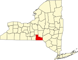
Nineveh is a hamlet with approximately fifty homes on the banks of the Susquehanna River in Broome County, New York, United States. It is part of the Town of Colesville, Binghamton metropolitan area in eastern Broome County. Nineveh is located on the USGS Afton quadrangle at an elevation of about 960 feet. [1] Nineveh takes its name from ancient Nineveh, the most important city on the Tigris River in the ancient kingdom of Assyria (now Iraq).

Nineveh is located along the tracks of the Delaware and Hudson Railway and has a distinct trestle located there.

New York State Route 7 is the main road through the hamlet, with several small businesses serving the residents' basic needs located along it.

In June 2006, widespread flooding along the river basin inundated many homes along the banks of the river. [2]

Notable people

Related Research Articles

<span class="mw-page-title-main">Nineveh</span> Ancient Assyrian city

Nineveh, also known in early modern times as Kouyunjik, was an ancient Assyrian city of Upper Mesopotamia, located in the modern-day city of Mosul in northern Iraq. It is located on the eastern bank of the Tigris River and was the capital and largest city of the Neo-Assyrian Empire, as well as the largest city in the world for several decades. Today, it is a common name for the half of Mosul that lies on the eastern bank of the Tigris, and the country's Nineveh Governorate takes its name from it.

<span class="mw-page-title-main">Kirkwood, New York</span> Town in New York, United States

Kirkwood is a town in Broome County, New York, United States. The population was 5,495 at the 2020 census. The town is named after James P. Kirkwood, who was an engineer responsible for constructing the local railroad.

<span class="mw-page-title-main">Augusta, New York</span> Town in New York, United States

Augusta is a town in Oneida County, New York, United States. The population was 2,020 at the 2010 census.

<span class="mw-page-title-main">Afton, New York</span> Town in New York, United States

Afton is a town in Chenango County, New York, United States. The population was 2,769 at the 2020 census. Afton is situated in the southeast corner of the county and lies wholly within the original Township of Clinton. It was formed from the town of Bainbridge on November 18, 1857, and derives its name from Afton Water, a small river in the parish of New Cumnock, Ayrshire, Scotland, immortalized by the poet Robert Burns. It is bounded on the north by Bainbridge and Coventry, on the east by Delaware County, and on the west and south by Broome County.

<span class="mw-page-title-main">Owego, New York</span> Town in Tioga County, New York, US

Owego is a town in Tioga County, New York, United States. The population was 18,728 at the 2020 census. The name is derived from the Iroquois word Ahwaga, meaning "where the valley widens".

<span class="mw-page-title-main">Mohawk River</span> River in the U.S. state of New York

The Mohawk River is a 149-mile-long (240 km) river in the U.S. state of New York. It is the largest tributary of the Hudson River. The Mohawk flows into the Hudson in Cohoes, New York, a few miles north of the state capital of Albany. The river is named for the Mohawk Nation of the Iroquois Confederacy. A major waterway, in the early 19th century, the river's east-west valley provided the setting and water for development of the Erie Canal, as a key to developing New York. The largest tributary, the Schoharie Creek, accounts for over one quarter (26.83%) of the Mohawk River's watershed. Another main tributary is the West Canada Creek, which makes up for 16.33% of the Mohawk's watershed.

<span class="mw-page-title-main">Johnny Hart</span> American cartoonist

John Lewis Hart was an American cartoonist noted as the creator of the comic strips B.C. and The Wizard of Id. Brant Parker co-produced and illustrated The Wizard of Id. Hart was recognized with several awards, including the Swedish Adamson Award and five from the National Cartoonists Society. In his later years, he was known for incorporating Christian themes and messages into his strips. Hart was referred to by Chuck Colson in a Breakpoint column as "the most widely read Christian of our time," over C. S. Lewis, Frank E. Peretti, and Billy Graham.

<span class="mw-page-title-main">West Branch Delaware River</span> River in New York, United States

The West Branch Delaware River is one of two branches that form the Delaware River. It is approximately 90 mi (144 km) long, and flows through the U.S. states of New York and Pennsylvania. It winds through a mountainous area of New York in the western Catskill Mountains for most of its course, before joining the East Branch along the northeast border of Pennsylvania with New York. Midway or so it is empounded by the Cannonsville Dam to form the Cannonsville Reservoir, both part of the New York City water supply system for delivering drinking water to the City.

<i>B.C.</i> (comic strip) American comic strip created by cartoonist Johnny Hart

B.C. is a daily American comic strip created by cartoonist Johnny Hart. Set in prehistoric times, it features a group of cavemen and anthropomorphic animals from various geologic eras.

<span class="mw-page-title-main">New York State Route 7</span> State highway in New York, United States

New York State Route 7 (NY 7) is a 180.30-mile-long (290.16 km) state highway in New York in the United States. The highway runs from Pennsylvania Route 29 (PA 29) at the Pennsylvania state line south of Binghamton in Broome County, New York, to Vermont Route 9 (VT 9) at the Vermont state line east of Hoosick in Rensselaer County. Most of the road runs along the Susquehanna Valley, closely paralleling Interstate 88 (I-88) throughout that road's length. Portions of the highway route near the cities of Binghamton, Schenectady, and Troy date back to the early 19th century.

<span class="mw-page-title-main">Esopus Creek</span> Tributary of the Hudson River in the Catskill region of New York state

Esopus Creek is a 65.4-mile-long (105.3 km) tributary of the Hudson River that drains the east-central Catskill Mountains in the U.S. state of New York. From its source at Winnisook Lake on the slopes of Slide Mountain, the Catskills' highest peak, it flows across Ulster County to the Hudson at Saugerties. Many tributaries extend its watershed into neighboring Greene County and a small portion of Delaware County. Midway along its length, it is impounded at Olive Bridge to create Ashokan Reservoir, the first of several built in the Catskills as part of New York City's water supply system. Its own flow is supplemented 13 miles (21 km) above the reservoir by the Shandaken Tunnel, which carries water from the city's Schoharie Reservoir into the creek.

<span class="mw-page-title-main">New York State Route 42</span> State highway in New York, US

New York State Route 42 (NY 42) is a north–south, discontinuous state highway in the Catskill Mountains region of New York in the United States. The southernmost of the highway's two segments begins at an intersection with U.S. Route 6 (US 6) and US 209 in Port Jervis and ends at a junction with NY 55 near the Rondout Reservoir in Neversink. NY 42's northern segment runs from NY 28 in Shandaken to NY 23A in Lexington. The 41-mile (66 km) southern segment is located in Orange County and Sullivan County, while the 11-mile (18 km) northern segment is in Ulster County and Greene County.

<span class="mw-page-title-main">New York State Route 41</span> State highway in central New York, US

New York State Route 41 (NY 41) is a north–south state highway in Central New York in the United States. The southern terminus of the route is at an interchange with NY 17 in the town of Sanford in Broome County, New York. Its northern terminus is at an intersection with U.S. Route 20 (US 20) in the village of Skaneateles. The route is almost 100 miles (161 km) long and passes through Broome, Chenango, Cortland, and Onondaga counties. NY 41 was assigned as part of the 1930 renumbering of state highways in New York, replacing New York State Route 70 from Homer to Skaneateles. The route initially extended as far north as Jordan; however, NY 41 was cut back to its current northern terminus c. 1933.

<span class="mw-page-title-main">New York State Route 434</span> Highway in New York

New York State Route 434 (NY 434) is a state highway located in the Southern Tier of New York in the United States. The route extends for 20.89 miles (33.62 km) from an intersection with NY 96 in the village of Owego to an intersection with U.S. Route 11 (US 11) in the city of Binghamton. In between, NY 434 passes through the towns of Owego and Vestal. The portion of NY 434 from the Tioga–Broome county line to downtown Binghamton is known as the Vestal Parkway.

The B.C. Open was a PGA Tour golf tournament in New York, held annually from 1971 to 2006. In 1971, it was called the Broome County Open, and the next year it switched to the B.C. Open. In 1973, it became a PGA Tour regular 72-hole money event. From 2000 to 2006, it took place during the same week as The Open Championship, so the leading players were not available and it was one of the smaller events on the PGA Tour schedule. The purse for the final edition in 2006 was $3 million.

<span class="mw-page-title-main">Poesten Kill</span> River in New York, United States

The Poesten Kill is a 26.2-mile-long (42.2 km) creek in upstate New York located entirely in Rensselaer County, which flows westerly from its source at Dyken Pond in the town of Berlin to its mouth at the Hudson River in the city of Troy. The Poesten Creek has historically been used as a source of water for the local inhabitants and farmers. during the Industrial Revolution it became even more important as a source of water power, and many mills and factories sprung up along its banks

<span class="mw-page-title-main">Verkeerder Kill</span> Tributary of the Shawangunk Kill in New Yorks Hudson Valley

The Verkeerder Kill, sometimes Verkeerderkill and locally shortened to Kaidy Kill is an 8-mile-long (13 km) stream in Ulster County, New York, United States. It rises on the Shawangunk Ridge, in the town of Wawarsing, and flows southwards through the town of Shawangunk, toward the Shawangunk Kill, itself a major tributary of the Wallkill River. Ultimately it is a part of the Hudson River's watershed.

<span class="mw-page-title-main">Canajoharie Creek</span> Watercourse in the United States of America

The Canajoharie Creek is a river that flows into the Mohawk River in the Village of Canajoharie in the U.S. State of New York. The name "Canajoharie" is a Mohawk language term meaning "the pot that washes itself", referring to the "Canajoharie Boiling Pot", a 20-foot (6.1 m) wide and 10-foot (3.0 m) deep pothole in the Canajoharie Creek, just south of the village of Canajoharie. Bowmans Creek is one main tributary that enters the creek east of the Hamlet of Sprout Brook. The other main tributary is Brimstone Creek which enters the creek north-northwest of the Village of Ames.

<span class="mw-page-title-main">West Kill</span> Tributary of the Schoharie Creek in Greene County, New York

The West Kill, an 11-mile-long (18 km) tributary of Schoharie Creek, flows through the town of Lexington, New York, United States, from its source on Hunter Mountain, the second-highest peak of the Catskill Mountains. Ultimately its waters reach the Hudson River via the Mohawk. Since it drains into the Schoharie upstream of Schoharie Reservoir, it is part of the New York City water supply system. It lends its name to both a mountain to its south and a small town midway along its length.

<span class="mw-page-title-main">Batavia Kill (Schoharie Creek tributary)</span> River in New York, United States

Batavia Kill is a 21-mile-long (34 km) tributary of Schoharie Creek, that flows across the towns of Windham, Ashland and Prattsville in the U.S. state of New York. Its waters reach the Hudson River via Schoharie Creek and the Mohawk River. Since it drains into the Schoharie upstream of Schoharie Reservoir, it is part of the New York City water supply system. From the source to Maplecrest, Batavia Kill drains the northern slopes of the Blackhead Mountains, which include Thomas Cole Mountain, Black Dome, and Blackhead Mountain, the fourth-, third-, and fifth-highest peaks in the Catskills, respectively.

References

  1. "USGS Historic Quadrangle Scanning Project". U.S. Geological Survey. Retrieved May 8, 2012.
  2. "Flood of June 2006". National Weather Service. Retrieved May 8, 2012.
  3. Fox, Emma Augusta (1914). "Parliamentary Usage for Women's Clubs: A Manual of Parliamentary Law and Practice, Designed for the Use of Societies, Literary, Social, Musical, Philanthropic, and Fraternal". Doubleday, Page & Company. Retrieved May 23, 2021.
  4. "Johnny Hart Dies at 76; Cartoonist Created 'B.C.'". New York Times. Associated Press. April 9, 2007. Retrieved May 8, 2012.

42°11′39″N75°36′09″W / 42.19417°N 75.60250°W / 42.19417; -75.60250