Chenango Bridge, New York

Last updated

Chenango Bridge
Chenango Bridge NY Locator Map.png
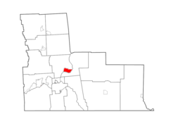
Map highlighting Chenango Bridge's location within Broome County.
New York Locator Map with US.PNG
Red pog.svg
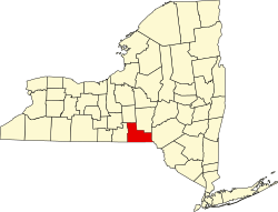
Chenango Bridge
Location within the state of New York
Coordinates: 42°10′00″N075°51′45″W / 42.16667°N 75.86250°W / 42.16667; -75.86250 [1]
CountryFlag of the United States.svg  United States
State Flag of New York.svg  New York
County Broome County
Town Chenango
Area
[2]
  Total
2.59 sq mi (6.71 km2)
  Land2.45 sq mi (6.34 km2)
  Water0.14 sq mi (0.37 km2)
Elevation
[1]
896 ft (273 m)
Population
 (2020)
  Total
2,884
  Density1,177.62/sq mi (454.68/km2)
Time zone UTC-5 (Eastern (EST))
  Summer (DST) UTC-4 (EDT)
ZIP code [3]
13745
Area code 607
FIPS code [4] [5] 36-15121
GNIS feature ID [5] 946480

Chenango Bridge is a hamlet in the southern part of the Town of Chenango in Broome County, New York, United States. It lies where State Route 12A (Chenango Bridge Road) crosses the Chenango River. The population was 2,883 at the 2010 census, which lists the community as a census-designated place. [6]

Geography

Chenango Bridge is located at 42°10′00″N075°51′45″W / 42.16667°N 75.86250°W / 42.16667; -75.86250 (42.1667426, -75.8624167) and its elevation is 896 feet (273 m). [1]

According to the 2010 United States Census, Chenango Bridge has a total area of 2.592 square miles (6.71 km2), of which 2.448 square miles (6.34 km2) is land and 0.144 square miles (0.37 km2) is water. [4]

Historical population
CensusPop.Note
2020 2,884
U.S. Decennial Census [7]

References

  1. 1 2 3 "Chenango Bridge". Geographic Names Information System . United States Geological Survey, United States Department of the Interior . Retrieved January 13, 2013.
  2. "ArcGIS REST Services Directory". United States Census Bureau. Retrieved September 20, 2022.
  3. "Post Offices By County: Broome County, New York". United States Postal Service. Archived from the original on March 4, 2016. Retrieved January 13, 2013.
  4. 1 2 "Places: New York". 2010 Census Gazetteer Files. United States Census Bureau. Archived from the original on February 17, 2013. Retrieved January 13, 2013.
  5. 1 2 "FIPS55 Data: New York". FIPS55 Data. United States Geological Survey. February 23, 2006. Archived from the original on October 19, 2006.
  6. "Profile of General Population and Housing Characteristics: 2010 Demographic Profile Data: Chenango Bridge CDP, New York". United States Census Bureau. Archived from the original on February 12, 2020. Retrieved January 12, 2013.
  7. "Census of Population and Housing". Census.gov. Retrieved June 4, 2016.