Whitney Point, New York

Last updated

Whitney Point, New York
Greetings from Whitney Point, New York.jpg
Main Street
Village of Whitney Point NY Locator Map.png
Map highlighting Whitney Point's location within Broome County.
USA New York location map.svg
Red pog.svg
Whitney Point
Location within the state of New York
Coordinates: 42°19′48″N75°58′12″W / 42.33000°N 75.97000°W / 42.33000; -75.97000
Country United States
State New York
County Broome
Town Triangle
Government
  MayorJason Somers
Area
[1]
  Total1.11 sq mi (2.88 km2)
  Land1.04 sq mi (2.70 km2)
  Water0.07 sq mi (0.18 km2)
Elevation
958 ft (292 m)
Population
 (2020)
  Total960
  Density920.42/sq mi (355.54/km2)
Time zone UTC-5 (Eastern (EST))
  Summer (DST) UTC-4 (EDT)
ZIP code
13862
Area code 607
FIPS code 36-81831 [2]
GNIS feature ID0971191 [3]
Website www.whitneypoint.org
Hotel Griffin, built 1899 Hotel Griffin, Whitney Point, New York.jpg
Hotel Griffin, built 1899

Whitney Point is a village in Broome County, New York, United States. The population was 964 at the 2010 census. [4] It is part of the Binghamton Metropolitan Statistical Area. The name comes from Thomas and William Whitney, early developers.

Contents

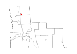
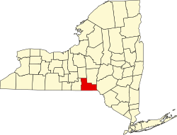
The village is in the southwestern corner of the town of Triangle and is north of Binghamton.

History

The village area was first settled around 1791 and began to flourish after the arrival of the Whitney family around 1800.

The village of Whitney Point (originally called "Whitney's Point") was incorporated in 1871. A catastrophic fire almost destroyed the village in 1897. After serious flooding in 1935 and 1936, work began on a dam north of the village on the Otselic River. It was completed in 1942 and — after decisions were later made to impound water on a year-round basis for recreational purposes — formed the Whitney Point Lake (Reservoir).

The village has been the site of the Broome County Fair since 1874.

The Whitney automobile was briefly manufactured in this village around 1902.

Grace Episcopal Church was listed on the National Register of Historic Places in 1998. [5]

The town slogan is "best town by a dam site" in reference to the Whitney Point Reservoir Dam in Dorchester Park. [6]

Geography

Whitney Point is located at 42°19′48″N75°58′12″W / 42.33000°N 75.97000°W / 42.33000; -75.97000 (42.330084, -75.970091). [7]

According to the United States Census Bureau, the village has a total area of 1.1 square miles (2.9 km2), of which 1.0 square mile (2.7 km2) is land and 0.077 square miles (0.2 km2), or 6.31%, is water. [4]

The village is located on the Tioughnioga River, by its junction with the Otselic River.

The village is located at the junction of NY 26, NY 79, NY 206, and US 11. Interstate 81 passes through the western side of the village, with access from Exit 8.

Demographics

Historical population
CensusPop.Note
1870 480
1880 81870.4%
1890 8422.9%
1900 807−4.2%
1910 744−7.8%
1920 665−10.6%
1930 639−3.9%
1940 73314.7%
1950 88320.5%
1960 1,04918.8%
1970 1,0580.9%
1980 1,0933.3%
1990 1,054−3.6%
2000 965−8.4%
2010 964−0.1%
2020 960−0.4%
U.S. Decennial Census [8]

As of the census [2] of 2000, there were 965 people, 397 households, and 244 families residing in the village. The population density was 966.2 inhabitants per square mile (373.1/km2). There were 432 housing units at an average density of 432.6 per square mile (167.0/km2). The racial makeup of the village was 96.89% White, 0.21% African American, 0.31% Native American, 0.21% Asian, 0.10% Pacific Islander, 0.52% from other races, and 1.76% from two or more races. Hispanic or Latino of any race were 1.55% of the population.

There were 397 households, out of which 35.0% had children under the age of 18 living with them, 43.1% were married couples living together, 13.6% had a female householder with no husband present, and 38.3% were non-families. 31.2% of all households were made up of individuals, and 12.8% had someone living alone who was 65 years of age or older. The average household size was 2.43 and the average family size was 3.09.

In the village, the population was spread out, with 28.3% under the age of 18, 8.2% from 18 to 24, 26.5% from 25 to 44, 22.9% from 45 to 64, and 14.1% who were 65 years of age or older. The median age was 37 years. For every 100 females, there were 88.1 males. For every 100 females age 18 and over, there were 83.1 males.

The median income for a household in the village was $34,934, and the median income for a family was $44,667. Males had a median income of $30,875 versus $27,143 for females. The per capita income for the village was $17,608. About 10.9% of families and 13.2% of the population were below the poverty line, including 19.0% of those under age 18 and 4.3% of those age 65 or over.

Related Research Articles

<span class="mw-page-title-main">Conklin, New York</span> Town in New York, United States

Conklin is a town in Broome County, New York, United States. Per the 2020 census, the population was 5,008.

<span class="mw-page-title-main">Kirkwood, New York</span> Town in New York, United States

Kirkwood is a town in Broome County, New York, United States. The population was 5,495 at the 2020 census. The town is named after James P. Kirkwood, who was an engineer responsible for constructing the local railroad.

<span class="mw-page-title-main">Triangle, New York</span> Town in New York, United States

Triangle is a town in Broome County, New York, United States. The population was 2,946 at the 2010 census. The town's primary settlement is the village of Whitney Point.

<span class="mw-page-title-main">Coventry, New York</span> Town in New York, United States

Coventry is a town in Chenango County, New York, United States. The population was 1,655 at the 2010 census. The town is named after Coventry, Connecticut, by settlers from New England. Coventry is in the southern part of Chenango County and is northeast of Binghamton.

<span class="mw-page-title-main">Otselic, New York</span> Town in New York, United States

Otselic is a town in Chenango County, New York, United States, situated on the northern border of Chenango County, northwest of the city of Norwich. The population of the town was 1,054 at the 2010 census. The town is named after a river flowing through it, the Otselic, which is an Oneida word for "place of wild plums". The Otselic valley is the predominant geographic feature in the town, connecting it to the surrounding region north and south.

<span class="mw-page-title-main">Pharsalia, New York</span> Town in New York, United States

Pharsalia is a town in Chenango County, New York, United States. The population was 593 at the 2010 census. The town was named after Pharsalia, which is a commonly accepted name of the decisive battle in the Great Roman Civil War, where Julius Caesar defeated Pompey in 48 BCE.

<span class="mw-page-title-main">Pitcher, New York</span> Town in New York, United States

Pitcher is a town in Chenango County, New York, United States. The population was 803 at the 2010 census. The town is named after Nathaniel Pitcher, the eighth governor of New York. The town is on the western border of Chenango County, west of the city of Norwich.

<span class="mw-page-title-main">Plymouth, New York</span> Town in New York, United States

Plymouth is a town in Chenango County, New York, United States. The population was 1,804 at the 2010 census. It is an interior town in the northern part of the county. The town is northwest of the city of Norwich. Plymouth was also known as Plymouth Rock.

<span class="mw-page-title-main">Cincinnatus, New York</span> Town in New York, United States

Cincinnatus is a town in Cortland County, New York, United States. The population was 910 at the 2020 census. The town is named after the Roman general Lucius Quinctius Cincinnatus. It is in the eastern part of the county and is east of the city of Cortland.

<span class="mw-page-title-main">Willet, New York</span> Town in New York, United States

Willet is a town in Cortland County, New York, United States. The population was 1,043 at the 2010 census. The town is named after Colonel Marinus Willet. It is in the southeast corner of the county, southeast of the City of Cortland.

<span class="mw-page-title-main">Hadley, New York</span> Town in New York, United States

Hadley is a town in Saratoga County, New York, United States. The population was 1,971 at the 2000 census. The town was named after Hadley, Massachusetts.

<span class="mw-page-title-main">Conesville, New York</span> Town in New York, United States

Conesville is a town in Schoharie County, New York, United States. The population was 687 at the 2020 census. The town is named after Jonathan Cone, an early resident.

<span class="mw-page-title-main">Gilboa, New York</span> Town in New York, United States

Gilboa is a town in Schoharie County, New York, United States. The population was 1,111 at the 2020 census.

<span class="mw-page-title-main">Binghamton (town), New York</span> Town in New York, United States

Binghamton is a town in Broome County, New York, United States. The population was 4,623 at the 2020 census. The town is named after an early developer, William Bingham.

<span class="mw-page-title-main">Lisle (village), New York</span> Village in New York, United States

Lisle is a village in Broome County, New York, United States. The population was 320 at the 2010 census. It is part of the Binghamton Metropolitan Statistical Area. The village was named after a community in France.

<span class="mw-page-title-main">Lisle, New York</span> Town in New York, United States

Lisle is a town in Broome County, New York, United States. The population was 2,751 at the 2010 census.

<span class="mw-page-title-main">Greene (village), New York</span> Village in New York, United States

Greene is a village in Chenango County, New York, United States. The population was 1,580 at the 2010 census. The village is named after General Nathanael Greene. It is within the town of Greene and is northeast of Binghamton.

<span class="mw-page-title-main">Sherburne (village), New York</span> Village in New York, United States

Sherburne is a village in Chenango County, New York, United States. The population was 1,367 at the 2010 census. It is in the town of Sherburne, north of Norwich.

Smyrna is a village in Chenango County, New York, United States. The population was 213 at the 2010 census. The village is located in the town of Smyrna and is near the northern border of Chenango County.

Deposit is a town in Delaware County, New York, United States. As of the 2010 census, the town's population was 1,712.

References

  1. "ArcGIS REST Services Directory". United States Census Bureau. Retrieved September 20, 2022.
  2. 1 2 "U.S. Census website". United States Census Bureau . Retrieved January 31, 2008.
  3. "US Board on Geographic Names". United States Geological Survey. October 25, 2007. Retrieved January 31, 2008.
  4. 1 2 "Geographic Identifiers: 2010 Demographic Profile Data (G001): Whitney Point village, New York". U.S. Census Bureau, American Factfinder. Archived from the original on February 12, 2020. Retrieved February 5, 2014.
  5. "National Register Information System". National Register of Historic Places . National Park Service. March 13, 2009.
  6. "Whitney Point Reservoir - NYS Dept. of Environmental Conservation". www.dec.ny.gov. Retrieved August 14, 2019.
  7. "US Gazetteer files: 2010, 2000, and 1990". United States Census Bureau. February 12, 2011. Retrieved April 23, 2011.
  8. "Census of Population and Housing". Census.gov. Retrieved June 4, 2015.