Non-volcanic passive margins

Last updated

Non-volcanic passive margins (NVPM) constitute one end member of the transitional crustal types that lie beneath passive continental margins; the other end member being volcanic passive margins (VPM). Transitional crust welds continental crust to oceanic crust along the lines of continental break-up. Both VPM and NVPM form during rifting, when a continent rifts to form a new ocean basin. NVPM are different from VPM because of a lack of volcanism. Instead of intrusive magmatic structures, the transitional crust is composed of stretched continental crust and exhumed upper mantle. NVPM are typically submerged and buried beneath thick sediments, so they must be studied using geophysical techniques or drilling. NVPM have diagnostic seismic, gravity, and magnetic characteristics that can be used to distinguish them from VPM and for demarcating the transition between continental and oceanic crust.

Contents

Typical characteristics

Non-Volcanic Passive Margin Cross Section.jpg

NVPM are the result of rifting when a continent breaks up to form an ocean, producing transitional crust without volcanism. Extension causes a number of events to occur. First is lithospheric thinning, which allows asthenospheric upwelling; heating further erodes the lithosphere, furthering the thinning process. The extensional forces also cause listric faults and continentward dipping reflectors that help identify NVPM and distinguish them from VPM, characterized by seaward-dipping seismic reflectors. The main difference between NVPM and VPM is that in the latter case, the mantle is hot enough to melt and produce voluminous basalts, whereas in the former case the mantle doesn't melt and there is little or no volcanism. Instead, extension simply pulls the crust away, exposing or "unroofing" the mantle, exposing serpentinized peridotite. The mantle doesn't melt because it is cold or upwells slowly, so there are no igneous rocks like there are in VPM. The basalts and granites are replaced with serpentinized peridotite, accompanied by unique serpentothermal and hydrothermal activity. Increasing density of the lithosphere as it cools and sediment accumulation causes subsidence.

Geophysical properties

Seismic characteristics

Seismic reflection lines across passive margins show many structural features common to both VPM and NVPM, such as faulting and crustal thinning, with the primary contra-indicator for volcanism being the presence of continent-ward dipping reflectors.

NVPM also display distinct p-wave velocity structures that differentiate them from VPM. Typical NVPM exhibit a high velocity, high gradient lower crust (6.4-7.7 km/s) overlain by a thin, low velocity (4–5 km/s) upper crustal layer. The high velocity shallow layer is usually interpreted as the serpentinized peridotite associated with NVPM. In some cases, an extremely thick igneous underplating of a VPM will display similar P-wave velocity (7.2-7.8 km/s, but with a lower gradient). For this reason, velocity structure alone cannot be used to determine the nature of a margin.

Gravity properties

Gravity data provides information about the subsurface density distribution. The most important gravity feature associated with any continent-ocean transition, including NVPM, is the free-air edge effect anomaly, which consists of a gravity high and a gravity low associated with the contrast between the thick continental and thin oceanic crust. There are also subsurface variations in density that cause significant variations across the continent-ocean transition. The crust, as well as the entire lithosphere, is thinned due to mechanical extension. The Moho marks a large density contrast between crust and mantle, typically at least 0.35 g/cm3. The highest amplitudes of the gravity anomaly occur seaward of the continent-ocean transition. High-density upper mantle material is elevated relative to the more landward crustal root. The oceanic crust density is then further enhanced with gabbros and basalts and additionally contributes to the regional gravity trend.

Where the thickness of the crust and lithosphere varies, equilibrium must be reached. Isostatic compensation and gravity anomalies result from balance between mass excess of the extra mantle beneath the thinned lithosphere and the overlying low-density crust. Positive gravity anomalies result from the relatively low flexural strength of the lithosphere during the beginning of rifting. As the passive margin matures, the crust and uppermost mantle become colder and stronger, so that the compensating deflection in the base of the lithosphere is broader than the actual rift. Higher flexural strength results in a broadening of the gravity anomaly with time.

Magnetic properties

The magnetic signature of a passive continental margin is influenced by the volume of material with a high magnetic susceptibility and the depth of the material below the surface. Large amplitude magnetic anomalies are associated with high magnetic susceptibility (~0.06 emu) igneous rocks of VPM. In contrast, NVPM exhibit only small amplitude anomalies associated with the edge effect at the boundary between the exhumed mantle (~0.003 emu) at the transition zone, and the true oceanic crust basalt (~0.05 emu). This anomaly can be used to locate the boundary between transitional crust and oceanic crust. The absence of large amplitude anomalies is a very strong indication that a margin is non-volcanic.

Formation

Crustal Thinning Sequence.jpg

Passive rifting

Passive rifting, unlike active rifting, occurs principally by extensional tectonic forces as opposed to magmatic forces originating from convection cells or mantle plumes. Isostatic forces allow mantle material to rise under the thinning lithosphere. Subsidence and sedimentation occur during both the initial rifting stage and the post rifting stages. Only after initial rifting does any mantle melting occur. Continued extension of the lithosphere will eventually lead to decompression melting of the mantle and the formation of a mid-ocean ridge. This process results in the creation of an ocean basin, and possibly conjugate NVPM. [1]

Rifting models

There are several models for forming NVPM. Passive rifting can follow McKenzie's pure shear model, Wernicke's simple shear model, or a composite model combining features of both, as observed at the Galicia bank NVPM.

McKenzie pure shear model

Pure shear describes “homogeneous flattening” of rocks without rotations, while maintaining a constant volume. If a cube undergoes pure shearing, the result will be a rectangular prism with sides parallel to those of the initial cube. McKenzie's model predicts symmetric structures on either side of the rift zone composed of rotated fault blocks bounded by normal faults. [2]

Wernicke simple shear model

In contrast to pure shear, simple shear describes constant volume strain with rotations. If a cube undergoes simple shearing, the result will be a parallelogram with sides that increase in length and are no longer parallel to the sides of the original cube. The top and bottom of the cube will neither stretch nor shorten. In a simple shear model, a basin is stretched asymmetrically by a large scale detachment fault extending from the upper crust to the lower lithosphere and even asthenosphere. [3]

Galicia bank

Composite model formation

During the Late Jurassic-Early Cretaceous, tectonic extensional forces created a shallow angle east-dipping detachment fault. This fault cut from what is now the Flemish Cap margin in Nova Scotia, eastern Canada to the Galicia margin, which is located west of the Iberian Peninsula. This fault penetrated the upper portion of the continental crust and merged into the transition between brittle upper and plastic lower crust. In time, displacement along this detachment fault decreased to zero at a point under the Galicia margin. East of this detachment fault, the structure of the Galicia NVPM is entirely pure shear resulting in rotated fault blocks, normal faults, and continent-ward dipping seismic reflectors. Simple shear is only evident in the western edge of the Galicia margin and the upper crust of the Flemish Cap margin where the crust is brittle. Below this brittle crust, the ductile crust follows McKenzie's pure shear model. Mantle material composed of peridotites is serpentinized by circulating seawater after it rises close enough to the upper crust due to its low density and isostatic forces. After sufficient thinning of the lithosphere, this serpentinized material is emplaced at the continent-ocean transition. This is why the transitional crust of NVPM are made of serpentinized peridotite instead of magmatic structures seen in VPM. Since the emplacement of the peridotite, oceanic crust has been forming at the Mid-Atlantic Ridge and driving the two NVPM apart. The simple shear detachment became a deactivated detachment fault once this rifting process began the formation of new oceanic crust. This process explains the structures seen at the Galicia margin today.

Geographic distribution

Globald.png

Related Research Articles

<span class="mw-page-title-main">Seafloor spreading</span> Geological process at mid-ocean ridges

Seafloor spreading, or seafloor spread, is a process that occurs at mid-ocean ridges, where new oceanic crust is formed through volcanic activity and then gradually moves away from the ridge.

<span class="mw-page-title-main">Subduction</span> A geological process at convergent tectonic plate boundaries where one plate moves under the other

Subduction is a geological process in which the oceanic lithosphere and some continental lithosphere is recycled into the Earth's mantle at convergent boundaries. Where the oceanic lithosphere of a tectonic plate converges with the less dense lithosphere of a second plate, the heavier plate dives beneath the second plate and sinks into the mantle. A region where this process occurs is known as a subduction zone, and its surface expression is known as an arc-trench complex. The process of subduction has created most of the Earth's continental crust. Rates of subduction are typically measured in centimeters per year, with rates of convergence as high as 11 cm/year.

Obduction is a geological process whereby denser oceanic crust is scraped off a descending ocean plate at a convergent plate boundary and thrust on top of an adjacent plate. When oceanic and continental plates converge, normally the denser oceanic crust sinks under the continental crust in the process of subduction. Obduction, which is less common, normally occurs in plate collisions at orogenic belts or back-arc basins.

<span class="mw-page-title-main">Ophiolite</span> Uplifted and exposed oceanic crust

An ophiolite is a section of Earth's oceanic crust and the underlying upper mantle that has been uplifted and exposed, and often emplaced onto continental crustal rocks.

<span class="mw-page-title-main">Island arc</span> Arc-shaped archipelago formed by intense seismic activity of long chains of active volcanoes

Island arcs are long chains of active volcanoes with intense seismic activity found along convergent tectonic plate boundaries. Most island arcs originate on oceanic crust and have resulted from the descent of the lithosphere into the mantle along the subduction zone. They are the principal way by which continental growth is achieved.

<span class="mw-page-title-main">Rift</span> Geological linear zone where the lithosphere is being pulled apart

In geology, a rift is a linear zone where the lithosphere is being pulled apart and is an example of extensional tectonics. Typical rift features are a central linear downfaulted depression, called a graben, or more commonly a half-graben with normal faulting and rift-flank uplifts mainly on one side. Where rifts remain above sea level they form a rift valley, which may be filled by water forming a rift lake. The axis of the rift area may contain volcanic rocks, and active volcanism is a part of many, but not all, active rift systems.

<span class="mw-page-title-main">Earth's mantle</span> A layer of silicate rock between Earths crust and its outer core

Earth's mantle is a layer of silicate rock between the crust and the outer core. It has a mass of 4.01×1024 kg (8.84×1024 lb) and makes up 67% of the mass of Earth. It has a thickness of 2,900 kilometers (1,800 mi) making up about 46% of Earth's radius and 84% of Earth's volume. It is predominantly solid but, on geologic time scales, it behaves as a viscous fluid, sometimes described as having the consistency of caramel. Partial melting of the mantle at mid-ocean ridges produces oceanic crust, and partial melting of the mantle at subduction zones produces continental crust.

<span class="mw-page-title-main">Iceland hotspot</span> Hotspot partly responsible for volcanic activity forming the Iceland Plateau and island

The Iceland hotspot is a hotspot which is partly responsible for the high volcanic activity which has formed the Iceland Plateau and the island of Iceland. It contributes to understanding the geological deformation of Iceland.

<span class="mw-page-title-main">Continental collision</span> Phenomenon in which mountains can be produced on the boundaries of converging tectonic plates

In geology, continental collision is a phenomenon of plate tectonics that occurs at convergent boundaries. Continental collision is a variation on the fundamental process of subduction, whereby the subduction zone is destroyed, mountains produced, and two continents sutured together. Continental collision is only known to occur on Earth.

<span class="mw-page-title-main">Passive margin</span> Transition between oceanic and continental lithosphere that is not an active plate margin

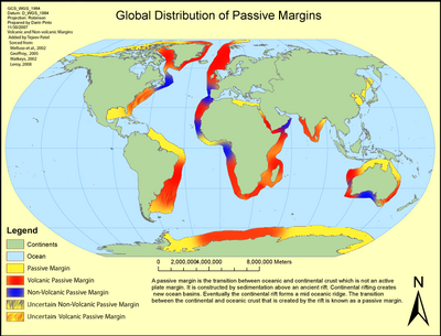
A passive margin is the transition between oceanic and continental lithosphere that is not an active plate margin. A passive margin forms by sedimentation above an ancient rift, now marked by transitional lithosphere. Continental rifting forms new ocean basins. Eventually the continental rift forms a mid-ocean ridge and the locus of extension moves away from the continent-ocean boundary. The transition between the continental and oceanic lithosphere that was originally formed by rifting is known as a passive margin.
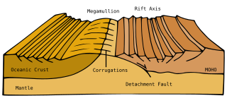
<span class="mw-page-title-main">Afar Triple Junction</span> Place where three tectonic rifts meet in East Africa

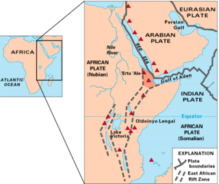
The Afar Triple Junction is located along a divergent plate boundary dividing the Nubian, Somali, and Arabian plates. This area is considered a present-day example of continental rifting leading to seafloor spreading and producing an oceanic basin. Here, the Red Sea Rift meets the Aden Ridge and the East African Rift. The latter extends a total of 6,500 kilometers (4,000 mi) from the Afar Triangle to Mozambique.

<span class="mw-page-title-main">Red Sea Rift</span> Oceanic rift between the African and Arabian Plates

The Red Sea Rift is a mid-ocean ridge between two tectonic plates, the African Plate and the Arabian Plate. It extends from the Dead Sea Transform fault system, and ends at an intersection with the Aden Ridge and the East African Rift, forming the Afar Triple Junction in the Afar Depression of the Horn of Africa.

Volcanic passive margins (VPM) and non-volcanic passive margins are the two forms of transitional crust that lie beneath passive continental margins that occur on Earth as the result of the formation of ocean basins via continental rifting. Initiation of igneous processes associated with volcanic passive margins occurs before and/or during the rifting process depending on the cause of rifting. There are two accepted models for VPM formation: hotspots/mantle plumes and slab pull. Both result in large, quick lava flows over a relatively short period of geologic time. VPM's progress further as cooling and subsidence begins as the margins give way to formation of normal oceanic crust from the widening rifts.

Tectonic subsidence is the sinking of the Earth's crust on a large scale, relative to crustal-scale features or the geoid. The movement of crustal plates and accommodation spaces produced by faulting brought about subsidence on a large scale in a variety of environments, including passive margins, aulacogens, fore-arc basins, foreland basins, intercontinental basins and pull-apart basins. Three mechanisms are common in the tectonic environments in which subsidence occurs: extension, cooling and loading.

<span class="mw-page-title-main">Opening of the North Atlantic Ocean</span> Breakup of Pangea

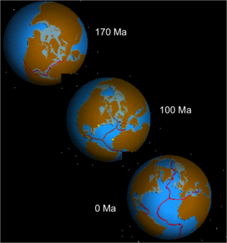
The opening of the North Atlantic Ocean is a geological event that has occurred over millions of years, during which the supercontinent Pangea broke up. As modern-day Europe and North America separated during the final breakup of Pangea in the early Cenozoic Era, they formed the North Atlantic Ocean. Geologists believe the breakup occurred either due to primary processes of the Iceland plume or secondary processes of lithospheric extension from plate tectonics.

<span class="mw-page-title-main">Samail Ophiolite</span>

The Samail Ophiolite, also known as the Semail Ophiolite, is a large, ancient geological formation in Oman and the United Arab Emirates in the Arabian Peninsula. It is one of the world's largest and best-exposed segments of oceanic crust, made of volcanic rocks and ultramafic rocks from the Earth's upper mantle that was overthrust onto the continental crust. This ophiolite provides insight into the dynamics of oceanic crust formation and the tectonic processes involved in the creation of ocean basins.

The Tyrrhenian Basin is a sedimentary basin located in the western Mediterranean Sea under the Tyrrhenian Sea. It covers a 231,000 km2 area that is bounded by Sardinia to the west, Corsica to the northwest, Sicily to the southeast, and peninsular Italy to the northeast. The Tyrrhenian basin displays an irregular seafloor marked by several seamounts and two distinct sub-basins - the Vavilov and Marsili basins. The Vavilov deep plain contains the deepest point of the Tyrrhenian basin at approximately 3785 meters. The basin trends roughly northwest–southeast with the spreading axis trending northeast–southwest.

Exhumed mantle is formed when mantle rocks are exhumed by extensional tectonics such that they appear at the seabed. This occurs in two main settings, either during seafloor spreading during the formation of oceanic core complexes, or during the rifting apart of continental crust during break-up on non-volcanic passive margins.

<span class="mw-page-title-main">Plate theory (volcanism)</span> Model of volcanic activities on Earth

The plate theory is a model of volcanism that attributes all volcanic activity on Earth, even that which appears superficially to be anomalous, to the operation of plate tectonics. According to the plate theory, the principal cause of volcanism is extension of the lithosphere. Extension of the lithosphere is a function of the lithospheric stress field. The global distribution of volcanic activity at a given time reflects the contemporaneous lithospheric stress field, and changes in the spatial and temporal distribution of volcanoes reflect changes in the stress field. The main factors governing the evolution of the stress field are:

  1. Changes in the configuration of plate boundaries.
  2. Vertical motions.
  3. Thermal contraction.

Intraplate volcanism is volcanism that takes place away from the margins of tectonic plates. Most volcanic activity takes place on plate margins, and there is broad consensus among geologists that this activity is explained well by the theory of plate tectonics. However, the origins of volcanic activity within plates remains controversial.

References

  1. Laurent Geoffroy (December 2005). "Les marges passives volcaniques". Comptes Rendus. Géoscience (in French). 337 (16): 1395–1408. doi:10.1016/J.CRTE.2005.10.006. ISSN   1778-7025. Wikidata   Q65581393.
  2. Dan McKenzie (June 1978). "Some remarks on the development of sedimentary basins". Earth and Planetary Science Letters . 40 (1): 25–32. Bibcode:1978E&PSL..40...25M. CiteSeerX   10.1.1.459.4779 . doi:10.1016/0012-821X(78)90071-7. ISSN   0012-821X. Wikidata   Q56523482.
  3. Brian Wernicke (1985). "Uniform-sense normal simple shear of the continental lithosphere". Canadian Journal of Earth Sciences . 22 (1): 108–125. Bibcode:1985CaJES..22..108W. doi:10.1139/E85-009. ISSN   1480-3313. Wikidata   Q65581400.

Additional Reading