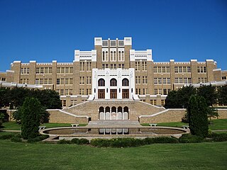
A secondary school or high school is an institution that provides secondary education and also usually includes the building where this takes place. Some secondary schools provide both lower secondary education and upper secondary education, i.e., both levels 2 and 3 of the ISCED scale, but these can also be provided in separate schools.
Norhamshire was an exclave of County Durham in England. It was first mentioned in 995, when it formed part of the lands of the priory at Lindisfarne. When the lands north of the River Tees were partitioned into Northumberland and County Durham it, along with Bedlingtonshire and Islandshire, stayed under the jurisdiction of Durham despite being north of the River Tyne.

The Oxford University Parks, commonly referred to locally as the University Parks, or just The Parks, is a large parkland area slightly northeast of the city centre in Oxford, England. The park is bounded to the east by the River Cherwell, though a small plot of land called Mesopotamia sits between the upper and lower levels of the river. To the north of the parks is Norham Gardens and Lady Margaret Hall, to the west the Parks Road, and the Science Area on South Parks Road to the south. The park is open to the public during the day, and has gardens, large sports fields, and exotic plants. It includes a cricket ground used by Oxford University Cricket Club.

North Shields is a town in the Borough of North Tyneside in Tyne and Wear, England. It is 8 miles (13 km) north-east of Newcastle upon Tyne and borders nearby Wallsend and Tynemouth.

The Ladykirk and Norham Bridge connects Ladykirk in the Borders, Scotland, with Norham in Northumberland, England, across the River Tweed. It's one of three bridges that cross it along the Anglo-Scottish Border, the others being the Coldstream Bridge and the Union Chain Bridge; out of these, the Ladykirk and Norham Bridge is the youngest, opening to the public in 1888.

North Oxford is a suburban part of the city of Oxford in England. It was owned for many centuries largely by St John's College, Oxford and many of the area's Victorian houses were initially sold on leasehold by the college.

Banbury Road is a major arterial road in Oxford, England, running from St Giles' at the south end, north towards Banbury through the leafy suburb of North Oxford and Summertown, with its local shopping centre. Parallel and to the west is the Woodstock Road, which it meets at the junction with St Giles'. To the north, Banbury Road meets the Oxford Ring Road at a roundabout. The road is designated the A4165. Prior to the building of the M40 motorway extension in 1990, the road formed part of the A423 from Maidenhead to Coventry.

Norham Gardens is a residential road in central North Oxford, England. It adjoins the north end of Parks Road near the junction with Banbury Road, directly opposite St Anne's College. From here it skirts the north side of the Oxford University Parks, ending up at Lady Margaret Hall, a college of Oxford University that was formerly for women only, backing onto the River Cherwell. Public access to the Parks is available from the two ends of the road. To the north of the road are Bradmore Road near the western end and Fyfield Road near the eastern end.

Tyne Metropolitan College is a college of further education in North Tyneside, England.
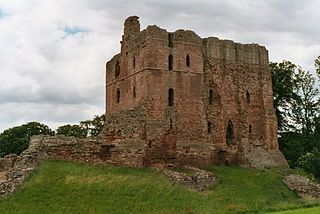
Norham Castle is a castle in Northumberland, England, overlooking the River Tweed, on the border between England and Scotland. It is a Grade I listed building and a Scheduled Ancient Monument. The castle saw much action during the wars between England and Scotland.

Green Templeton College (GTC) is a constituent college of the University of Oxford in the United Kingdom. The college is located on the former Green College site on Woodstock Road next to the Radcliffe Observatory Quarter in North Oxford and is centred on the architecturally important Radcliffe Observatory, an 18th-century building, modelled on the ancient Tower of the Winds at Athens. It is the university's second newest graduate college, after Reuben College, having been founded by the historic merger of Green College and Templeton College in 2008.

The Norham Manor estate is a residential suburb in Oxford, England. It is part of central North Oxford. To the north is Park Town with its crescents, to the east is the River Cherwell, to the south are the University Parks and to the west is Walton Manor, on the other side of Banbury Road.

Norham Road is a road which lies east of the Banbury Road in central North Oxford, a suburb in the city of Oxford, England.
Ladykirk is a village on the B6470 in the Scottish Borders area of Scotland, and the former Berwickshire, just north of the River Tweed and the Anglo-Scottish border. The town was formerly known as Upsettlington, but King James IV of Scotland renamed the town Ladykirk; the church is also known as St Mary's Church or Kirk of Steill. Ladykirk stands directly opposite Norham Castle, Northumberland, England
Frederick Codd was a British Gothic Revival architect and speculative builder who designed and built many Victorian houses in North Oxford, England.

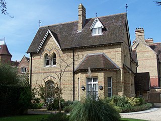
Crick Road is a road in North Oxford, England, an area characterised by large Victorian Gothic villas.
Percy Main is a small village absorbed into North Shields, North East England. Historically in Northumberland, it is now part of Tyne and Wear.
Meadow Well, also known as Meadowell or the Ridges, is a district of North Shields, North East England. Historically in Northumberland, it is now part of the Tyne and Wear Metropolitan county. The population in 2016 was approximately 11,000.
