
Tyne and Wear is a ceremonial county in North East England. It borders Northumberland to the north and County Durham to the south, and the largest settlement is the city of Newcastle upon Tyne.
South Tyneside is a metropolitan borough in the metropolitan county of Tyne and Wear, England. It is bordered by all four other boroughs in Tyne and Wear: Gateshead to the west, Sunderland in the south, North Tyneside to the north and Newcastle upon Tyne to the north-west. The border county of Northumberland lies further north. The borough was formed on 1 April 1974 by the merger of the County Borough of South Shields with the municipal borough of Jarrow and the urban districts of Boldon and Hebburn from County Durham.

South Shields is a coastal town in South Tyneside, Tyne and Wear, England; it is on the south bank of the mouth of the River Tyne. The town was once known in Roman times as Arbeia and as Caer Urfa by the Early Middle Ages. In 2021 it had a population of 75,337. It is the fourth largest settlement in Tyne and Wear, after Newcastle upon Tyne, Sunderland and Gateshead.

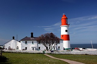
Tynemouth is a coastal town in the metropolitan borough of North Tyneside, in Tyne and Wear, England. It is located on the north side of the mouth of the River Tyne, hence its name. It is 8 mi (13 km) east-northeast of Newcastle upon Tyne. The medieval Tynemouth Priory and Castle stand on a headland overlooking both the mouth of the river and the North Sea, with the town centre lying immediately west of the headland.

North Shields is a town in the borough of North Tyneside in Tyne and Wear, England. It is 8 miles (13 km) north-east of Newcastle upon Tyne and borders nearby Wallsend and Tynemouth.

The Boldons is an area made up of the three villages of East Boldon, West Boldon and Boldon Colliery in South Tyneside in the county of Tyne and Wear, England. In 2001 they had a population of 13,271.
Longbenton High School is a smaller than average Secondary School located in Benton, North Tyneside, England. Operating under the two-tier system in North Tyneside, the school takes students from age 11-18. The school building also includes a very small Sixth Form, joint with George Stephenson High School. The joint sixth form used to be in partnership with Seaton Burn College and branded as the Northwest Cluster. However now it is simply known as 'NE12 Sixth Form', as both campuses fall under the NE12 Postcode. This change was not advertised at all by the school, both internally or externally.
Sacred Heart High School is a secondary school with academy status for girls. It is located on Fenham Hall Drive in Newcastle upon Tyne, England.

Shiremoor is a village in Tyne and Wear, Northern England. It is in the Metropolitan Borough of North Tyneside and formerly governed under Northumberland. In the 2011 census, it was included in the Tynemouth area of Tyneside. It is near the North East Green Belt, which surrounds Tyneside, Wearside and Durham. It is located around 3+1⁄2 miles from Whitley Bay.

Preston is a suburb about a mile north of North Shields, in the North Tyneside district, in the county of Tyne and Wear, England. Its population was recorded at 8419 in the 2011 census. Historically a separate entity, it has slowly been absorbed into the town to the south and expanded as to form a continuous urban area north to Monkseaton.

Cleadon is a suburban village in South Tyneside in the North East of England. Prior to the creation of Tyne and Wear in 1974 by the Local Government Act 1972, the village was part of the historic County Durham. In the 2011 UK Census the population of the South Tyneside ward of Cleadon and East Boldon was 8,427. Nearby population centres include East Boldon, Whitburn, and Jarrow. The village is located approximately 5 miles (8 km) from the city of Sunderland and 5 miles from the town South Shields. It is situated on the south west of Cleadon Hills, an example of a Magnesian Limestone grassland home to a number of regionally and nationally rare species.
West Harton is an area of the town of South Shields, in Tyne and Wear, England. It is primarily a residential area, with several schools and leisure facilities, including St Wilfrid's College and Brinkburn Recreation Ground. South Tyneside District Hospital is also situated in the area.

Kings Priory School is a mixed all-through school and sixth form located in Tynemouth, Tyne and Wear, England. The principal is Philip Sanderson. The school has a Christian foundation as the largest member of the Woodard Corporation, but accepts pupils of any religious background. It is located immediately to the east of Tynemouth Metro Station.
George Stephenson High School is a coeducational secondary school located in Killingworth, North Tyneside, England.

Westoe was originally a village near South Shields, in the South Tyneside district, in Tyne and Wear, England, but has since become part of the town and is now used to refer to the area of the town where the village once was. It is also an electoral ward for local political purposes.
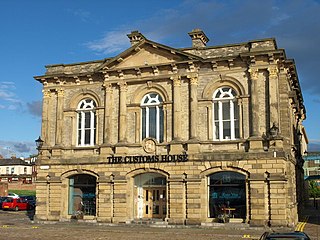
The Customs House is an arts and entertainment venue in the Mill Dam Conservation Area of South Shields, South Tyneside. It opened in July 1864 as a custom house, built to facilitate the import and export of goods at Shields Harbour. Before 1865, both North Shields and South Shields operated as a single customs port following their separation from the Newcastle Customs House in 1848. South Shields was granted customs independence from North Shields in 1865, in part due to the construction of the new custom house building in the town. An extension was added to the building in 1878 to house the Marine Board offices. In the 1970s, the decline of the local shipping industry meant the custom house became derelict. In 1992, the Tyne and Wear Development Corporation led a restoration effort and extension of the building, transforming it into an arts centre.
Jarrow School is a coeducational secondary school located in Jarrow, South Tyneside, England admitting pupils aged 11 to 16.

South Tyneside District Hospital is a healthcare facility providing healthcare services for South Shields, Jarrow, Hebburn, Boldon, Cleadon and Whitburn. It is managed by South Tyneside and Sunderland NHS Foundation Trust.

Harton is a suburban area of South Shields, South Tyneside, Tyne and Wear, England. It was historically a village, however as the urban area grew it merged with its adjacent villages to become part of the town. Some of the original village buildings are still intact today, such as St Peter's Church. Until 1974 it was in County Durham.

Temple Memorial Park is a park in South Shields, Tyne and Wear, England, given to the public by the Ecclesiastical Commissioners in 1946 and named after William Temple, the former archbishop of Canterbury.
