
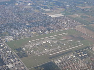
Ellington Airport is a public and military use airport in Harris County, Texas, United States. It is owned by the City of Houston's department of aviation, Houston Airport System and located 15 nmi southeast of downtown Houston. Formerly known as Ellington Field, then Ellington Air Force Base, then again as Ellington Field it is included in the National Plan of Integrated Airport Systems for 2011–2015, which categorized it as a general aviation reliever airport. The airport does not have scheduled commercial passenger service. However, Continental Airlines used to operate daily regional services between Ellington and Houston's George Bush Intercontinental Airport between 1990 and 2004. On 17 October 2018, the City of Houston approved Phase 1 of the Houston Spaceport project on the Ellington Airport site.

Rhode Island T. F. Green International Airport is a public international airport in Warwick, Rhode Island, United States, 6 miles south of the state's capital and largest city of Providence. Opened in 1931, the airport was named for former Rhode Island governor and longtime senator Theodore Francis Green. Rebuilt in 1996, the renovated main terminal was named for former Rhode Island governor Bruce Sundlun. It is the first state-owned airport in the United States.
Miami Executive Airport, formerly known until 2014 as Kendall-Tamiami Executive Airport, is a public airport in unincorporated Miami-Dade County, Florida, 13 miles (21 km) southwest of Downtown Miami. It is operated by the Miami-Dade Aviation Department.

Molokai Airport, also known as Hoolehua Airport is a state-owned, public use airport located six nautical miles northwest of Kaunakakai, on the island of Molokai in Maui County, Hawaii, United States. It is the principal airport of the island. The largest plane to ever fly here regularly was a Boeing 737-200 jet, which seats 127 passengers.

Lawrence J. Timmerman Airport, known locally as Timmerman Field, is an airport in Milwaukee, Wisconsin, United States, owned by Milwaukee County. Located 5 miles (8 km) northwest of the city center, it is used mainly for general or private aviation. It is included in the Federal Aviation Administration (FAA) National Plan of Integrated Airport Systems for 2023–2027, in which it is categorized as a regional reliever airport facility.

Quonset State Airport is a joint civil-military public airport located on Quonset Point, in northeastern North Kingstown, Rhode Island, United States, adjacent to Narragansett Bay. It is a general aviation airport and there is no scheduled airline service available. It is included in the Federal Aviation Administration (FAA) National Plan of Integrated Airport Systems for 2023–2027, in which it is categorized as a regional reliever facility.
Fort Lauderdale Executive Airport is a general aviation airport located within the city limits of Fort Lauderdale, in Broward County, Florida, United States, five miles (8.0 km) north of downtown Fort Lauderdale. It is a division of the Transportation and Mobility Department of the City of Fort Lauderdale.
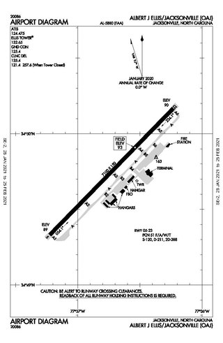
Albert J. Ellis Airport is a county-owned public-use airport in Onslow County, North Carolina, United States. It is located in Richlands, 10 nautical miles (19 km) northwest of the central business district of Jacksonville and Marine Corps Base Camp Lejeune. The airport has a single runway and three gates. Opening on February 15, 1971, the airport is used by general aviation, the military and two commercial airlines, American Eagle and Delta Connection.

Newport State Airport is a state-owned public-use airport in Newport County, Rhode Island, United States. It serves the city of Newport and is located 2 nmi northeast of its central business district. It is included in the Federal Aviation Administration (FAA) National Plan of Integrated Airport Systems for 2023–2027, in which it is categorized as a basic general aviation facility. There is no scheduled airline service available, but it once was served by Air New England.

Central Wisconsin Airport, referred to as "C-Way", is a public airport located 3 nautical miles southeast of the central business district of Mosinee, in Marathon County, Wisconsin, United States. It is owned by Marathon County and Portage County. It is included in the Federal Aviation Administration (FAA) National Plan of Integrated Airport Systems for 2023–2027, in which it is categorized as a non-hub primary commercial service facility. It is the fifth busiest of eight commercial airports in Wisconsin in terms of passengers served.
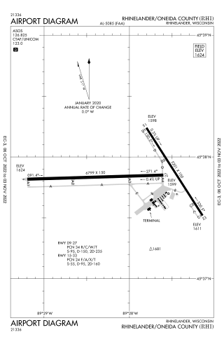
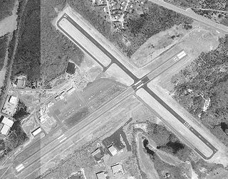
Rhinelander–Oneida County Airport is a public use airport located 2 nautical miles southwest of the central business district of Rhinelander, a city in Oneida County, Wisconsin, United States. The airport is owned by the city and county. It is primarily used for general aviation and is also served by one commercial airline.
Westerly State Airport is a public use airport in Washington County, Rhode Island, United States. It serves the town of Westerly and is located 2 nmi southeast of its central business district. It is primarily a general aviation airport, but there is also scheduled airline service to Block Island provided by New England Airlines.

Westfield-Barnes Regional Airport is a joint civil-military airport in Hampden County, Massachusetts, three miles (6 km) north of Westfield and northwest of Springfield. It was formerly Barnes Municipal Airport; the National Plan of Integrated Airport Systems for 2011–2015 categorized it as a general aviation facility. Westfield-Barnes is one of Massachusetts' largest airports with a strong flight training, general aviation, and military presence. It is also known as Barnes Air National Guard Base.

Phoenix Goodyear Airport is a public airport in Goodyear, Arizona in Maricopa County, Arizona, United States.

Block Island State Airport is a public use airport located on Block Island, in Washington County, Rhode Island, United States. The airport is owned by the State of Rhode Island. It is primarily a general aviation airport, but there is also scheduled airline service to Westerly State Airport. The airport opened in 1950.

Kenosha Regional Airport is a city-owned public-use airport located four nautical miles (7 km) west of the central business district of Kenosha, a city in Kenosha County, Wisconsin, United States.
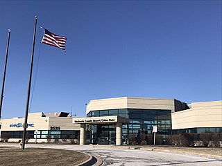
Waukesha County Airport/Crites Field is a public use airport located two miles (3 km) north of the central business district of Waukesha, a city in Waukesha County, Wisconsin, United States. It is owned and operated by Waukesha County. It is included in the Federal Aviation Administration (FAA) National Plan of Integrated Airport Systems for 2023–2027, in which it is categorized as a national reliever aviation facility.
West Bend Municipal Airport is a city-owned public-use airport located three nautical miles (6 km) east of the central business district of West Bend, a city in Washington County, Wisconsin, United States. It is included in the Federal Aviation Administration (FAA) National Plan of Integrated Airport Systems for 2023–2027, in which it is categorized as a regional reliever airport facility.

Treasure Coast International Airport is a public airport located three miles (5 km) northwest of the central business district of Fort Pierce, a city in St. Lucie County, Florida, United States. It is owned by the St. Lucie Board of County Commissioners.

Chesterfield County Airport is a public airport located 10 miles southwest of the central business district of Richmond, Virginia, United States, in unincorporated Chesterfield County. It is owned by Chesterfield County.

