
The Great Basin Desert is part of the Great Basin between the Sierra Nevada and the Wasatch Range. The desert is a geographical region that largely overlaps the Great Basin shrub steppe defined by the World Wildlife Fund, and the Central Basin and Range ecoregion defined by the U.S. Environmental Protection Agency and United States Geological Survey. It is a temperate desert with hot, dry summers and snowy winters. The desert spans large portions of Nevada and Utah, and extends into eastern California. The desert is one of the four biologically defined deserts in North America, in addition to the Mojave, Sonoran, and Chihuahuan Deserts.
British Columbia mainland coastal forests is a temperate coniferous forest ecoregion the Pacific coast of North America, as defined by the World Wildlife Fund (WWF) categorization system.

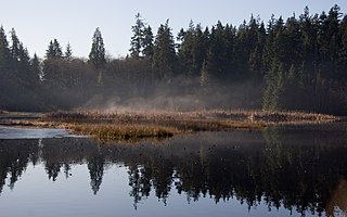
The New England-Acadian forests are a temperate broadleaf and mixed forest ecoregion in North America that includes a variety of habitats on the hills, mountains and plateaus of New England and New York State in the Northeastern United States, and Quebec and the Maritime Provinces of Eastern Canada.

The Cascades ecoregion is a Level III ecoregion designated by the United States Environmental Protection Agency (EPA) in the U.S. states of Washington, Oregon, and California. Somewhat smaller than the Cascade mountain range for which it is named, the ecoregion extends north to Snoqualmie Pass, near Seattle, and south to Hayden Pass, near the Oregon-California border, including the peaks and western slopes of most of the High Cascades. A discontiguous section is located on Mount Shasta in California.

The Eastern Cascades Slopes and Foothills ecoregion is a Level III ecoregion designated by the United States Environmental Protection Agency (EPA) in the U.S. states of Oregon, Washington, and California. In the rain shadow of the Cascade Range, the eastern side of the mountains experiences greater temperature extremes and receives less precipitation than the west side. Open forests of ponderosa pine and some lodgepole pine distinguish this region from the Cascades ecoregion, where hemlock and fir forests are more common, and from the lower, drier ecoregions to the east, where shrubs and grasslands are predominant. The vegetation is adapted to the prevailing dry, continental climate and frequent wildfire. Volcanic cones and buttes are common in much of the region.

The Klamath Mountains ecoregion of Oregon and California lies inland and north of the Coast Range ecoregion, extending from the Umpqua River in the north to the Sacramento Valley in the south. It encompasses the highly dissected ridges, foothills, and valleys of the Klamath and Siskiyou Mountains. It corresponds to the Level III ecoregion designated by the Environmental Protection Agency and to the Klamath-Siskiyou forests ecoregion designated by the World Wide Fund for Nature.
The biogeoclimatic zones of British Columbia are units of a classification system used by the British Columbia Ministry of Forests for the Canadian province's fourteen different broad, climatic ecosystems. The classification system, termed Biogeoclimatic Ecosystem Classification, exists independently of other ecoregion systems, one created by the World Wildlife Fund and the other in use by Environment Canada, which is based on one created by the Commission for Environmental Cooperation (CEC) and also in use by the US Environmental Protection Agency (EPA). The system of biogeoclimatic ecosystem classification was partly created for the purpose of managing forestry resources, but is also in use by the British Columbia Ministry of Environment and Climate Change Strategy and other provincial agencies. A biogeoclimatic zone is defined as "a geographic area having similar patterns of energy flow, vegetation and soils as a result of a broadly homogenous macroclimate."
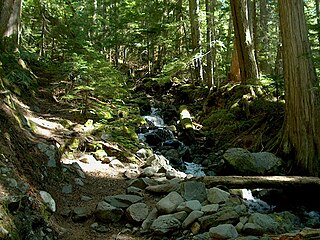
The Ecology of the North Cascades is heavily influenced by the high elevation and rain shadow effects of the mountain range. The North Cascades is a section of the Cascade Range from the South Fork of the Snoqualmie River in Washington, United States, to the confluence of the Thompson and Fraser Rivers in British Columbia, Canada, where the range is officially called the Cascade Mountains but is usually referred to as the Canadian Cascades. The North Cascades Ecoregion is a Level III ecoregion in the Commission for Environmental Cooperation's classification system.
The Central Pacific coastal forests is a temperate coniferous forest ecoregion located in the Canadian province of British Columbia and the U.S. states of Oregon and Washington, as defined by the World Wildlife Fund (WWF) categorization system.

The eastern forest–boreal transition is a temperate broadleaf and mixed forests ecoregion of North America, mostly in eastern Canada. It is a transitional zone or region between the predominantly coniferous Boreal Forest and the mostly deciduous broadleaf forest region further south.

The North Central Rockies forests is a temperate coniferous forest ecoregion of Canada and the United States. This region overlaps in large part with the North American inland temperate rainforest and gets more rain on average than the South Central Rockies forests and is notable for containing the only inland populations of many species from the Pacific coast.

The Altai montane forest and forest steppe ecoregion covers patches of the subalpine forest belt on the Altai Mountains, crossing the border region where Russia, Kazakhstan, Mongolia and China meet. The region has high biodiversity, as it is located in transition zones between different ecoregions, altitudes, and climate zones. It is in the Palearctic realm, with a Cold semi-arid climate. It covers 35,199,998 km2 (13,590,795 sq mi).

The Changbai Mountains mixed forests ecoregion covers the Changbai Mountains and surrounding foothills in China and North Korea. The region features extensive and naturally preserved deciduous and conifer forests. The region exhibits high biodiversity due to its relative isolation, temperate climate with high rainfall, and centrality to central Chinese, Siberian, and European floral communities. In 1979, a significant portion of the ecoregion was designated the Changbaishan Biosphere Reserve by UNESCO.

The Qin Ling Mountains deciduous forests ecoregion covers the Qin Mountains, which run west-to-east across central China. The mountains effectively divide the biological regions of China into north and south. To the north is the Yellow River basin, a loess-soil region of temperate deciduous forests. To the south is the Yangtze River basic, a subtropical forest region. In between, the Qin Mountains support many rare and endemic species, including the Giant panda and the Sichuan snub-nosed monkey.
The Manchurian mixed forests ecoregion covers the forested hills surrounding the river plains of northern China, Russia, North Korea, and South Korea. The ecoregion supports a number of rare species due to the relative isolation, the diversity of habitat, with mixed forests of deciduous Mongolian oak and conifers of Korean pine. Because mountains rise above the region on three sides, with plains and wetlands below, the area supports high biodiversity as a transition zone.
Puget lowland forests is a temperate coniferous forest ecoregion on the Pacific coast of North America, as defined by the World Wildlife Fund (WWF) categorization system.

The Central British Columbia Mountain forests is a temperate coniferous forest ecoregion in north-central British Columbia, as defined by the World Wildlife Fund (WWF) categorization system.

Pacific Coastal Mountain icefields and tundra is a tundra ecoregion in Alaska, British Columbia, and Yukon, as defined by the World Wildlife Fund (WWF) categorization system.

Northern Cordillera forests is a taiga ecoregion that extends across the northern interior of British Columbia, southern Yukon, and a small area of the Northwest Territories as defined by the World Wildlife Fund (WWF) categorization system.

The Interior Yukon-Alaska alpine tundra ecoregion covers alpine, sub-alpine, and boreal forest areas along the cordillera of Interior Alaska and south-central Yukon Territory. Geologically, they are the disjunct uplands of the Yukon-Tanana Terrane plus a southern extension of the Brooks Range. The cover is extensive 'dark taiga' of closed spruce forest, open forest of other species, and alpine vegetation at higher altitudes. The region is mostly wilderness and relatively untouched by human development.

