Northgate, North Dakota | |
|---|---|
 | |
 Northgate, North Dakota  Northgate, North Dakota | |
| Coordinates: 48°59′27″N102°15′44″W / 48.99083°N 102.26222°W | |
| Country | United States |
| State | North Dakota |
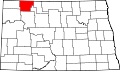
| County | Burke |
| Elevation | 1,860 ft (570 m) |
| Time zone | UTC-6 (Central (CST)) |
| • Summer (DST) | UTC-5 (CDT) |
| ZIP code | 58737 |
| Area code | 701 |
| GNIS feature ID | 1030491 [1] |
Northgate is an unincorporated community in Burke County, North Dakota, United States. The community is adjacent to the U.S. border with Canada, and it shares its name with the neighboring Canadian settlement of Northgate, Saskatchewan. The community is served by North Dakota Highway 8. [2] Northgate had its own post office until 1985. [3]
Contents
The former Port of Entry building was razed in 2014–2015. Almost all of Northgate, Saskatchewan, was razed in 2013–2014 to make room for an extension of the Canadian National Railway.