
The North–South Line (NSL) is a high-capacity Mass Rapid Transit (MRT) line in Singapore, operated by SMRT Corporation. Coloured red on the Singapore rail map, the line is 45 kilometres (28 mi) long and serves 27 stations, 11 of which, between the Bishan and Marina South Pier stations, are underground. It runs from Jurong East station, located in Western Singapore, to Marina South Pier station in the Central Area, via Woodlands station in northern Singapore. The line operates for almost 20 hours a day, with headways of up to 1 to 2 minutes during peak hours and 5 to 8 minutes during off-peak hours. All the trains on the North–South Line run with a six-car formation.

SMRT Corporation is a multi-modal public transport operator in Singapore operating bus and rail services. A subsidiary of the Government of Singapore's Temasek Holdings, it was established on 6 August 1987 and listed on the Singapore Exchange from 26 July 2000 until 31 October 2016. It is one of the two major operators of Singapore's rail services along with SBS Transit.
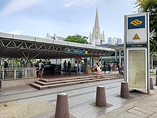
City Hall MRT station is an underground Singapore Mass Rapid Transit (MRT) interchange station on the North–South line (NSL) and East–West line (EWL). Situated in the Downtown Core district, it is underneath Stamford Road near the road junctions with North Bridge Road and St Andrew's Road. The station is near landmarks such as the former City Hall, Raffles City, the Padang, St Andrew's Cathedral and the Cenotaph.

Raffles Place MRT station is an underground Mass Rapid Transit (MRT) interchange station on the North–South Line (NSL) and East–West Line (EWL) in Singapore. Located in the Downtown Core, the station is underneath Raffles Place south of the Singapore River. The station serves various landmarks including The Fullerton Hotel, Merlion Park and the Asian Civilisations Museum and various commercial buildings such as One Raffles Place and OCBC Centre.

Outram Park MRT station is an underground Mass Rapid Transit (MRT) interchange station in Singapore. The station is on the East–West, North East and Thomson–East Coast lines, and is located near the junction of Outram Road, Eu Tong Sen Street and New Bridge Road on the boundary of Bukit Merah and Outram planning areas. It is the closest MRT station to Singapore General Hospital, the Police Cantonment Complex, Outram Community Hospital and the Health Promotion Board. The station was included in the early plans of the MRT network in 1982; it was constructed as part of the Phase I MRT segment from Novena, and was completed in December 1987.

Dhoby Ghaut MRT station is an underground Mass Rapid Transit (MRT) interchange station on the North South, North East and Circle lines in Singapore. Located beneath the eastern end of Orchard Road shopping belt in Dhoby Ghaut, Museum Planning Area, the station is integrated with the commercial development The Atrium@Orchard. The station is near landmarks such as The Istana, the MacDonald House, Plaza Singapura and Dhoby Ghaut Green.

Bishan MRT station is a Mass Rapid Transit (MRT) interchange station on the North–South (NSL) and Circle (CCL) lines in Bishan, Singapore. The station is located along Bishan Road within the town centre; it is integrated with Junction 8 shopping centre and is close to Bishan Bus Interchange. Nearby schools include Raffles Institution, Catholic High School, and Kuo Chuan Presbyterian Primary and Secondary Schools.

Changi Airport MRT station is an underground Mass Rapid Transit (MRT) station in Changi, Singapore. The station is the terminus of the Changi Airport branch of the East–West Line (EWL); it is operated by SMRT Trains and is built in an east–west orientation. The station directly connects to Terminals 2 and 3 of Changi Airport and serves other airport amenities including the retail complex of Jewel.

Marina Bay MRT station is an underground Mass Rapid Transit (MRT) interchange station on the North South (NSL), Circle (CCL) and Thomson–East Coast (TEL) lines in Singapore. Located in the Downtown Core district near Marina Bay, the station serves the Marina One Residences, Marina Bay Suites and the Marina Bay Financial Centre.
Toa Payoh is a planning area and mature residential town located in the northern part of the Central Region of Singapore. Toa Payoh planning area borders Bishan and Serangoon to the north, the Central Water Catchment to the northwest, Kallang to the south, Geylang to the southeast, Novena to the west and Hougang to the east. Toa Payoh New Town is situated in the western portion of the Toa Payoh planning area. The latter occupies a much larger area, encompassing estates such as Potong Pasir and Bidadari.

The Central Expressway (CTE) in Singapore is the major highway connecting the city centre of Singapore with the northern residential parts of the island, including Toa Payoh, Bishan and Ang Mo Kio and further onwards to the Seletar Expressway and the Tampines Expressway.

Orchard MRT station is an underground Mass Rapid Transit (MRT) interchange station in Singapore, on the North South (NSL) and Thomson–East Coast (TEL) lines. Situated along Orchard Boulevard and underneath ION Orchard, the station serves various commercial and retail developments of the Orchard Road shopping district, including Liat Towers, Ngee Ann City, Wheelock Place, Wisma Atria and Shaw House, among others.

Somerset MRT station is an underground Mass Rapid Transit (MRT) station on the North–South Line in Orchard, Singapore. It is one of the three stations located along the popular shopping belt, Orchard Road.
Novena is a planning area located within the Central Region of Singapore. Novena is bounded by Toa Payoh to the north, Bukit Timah to the west, Tanglin to the south and Kallang to the east. While Novena is not classified as a "new town" by the Housing and Development Board (HDB), the estate of Whampoa within the subzone of Balestier constitutes part of the Kallang/Whampoa New Town.

Toa Payoh MRT station is an underground Mass Rapid Transit (MRT) station on the North South line (NSL) in Toa Payoh, Singapore. Located in the town centre of Toa Payoh, it is integrated with the Toa Payoh Bus Interchange and the HDB Hub, headquarters of the Housing and Development Board. The station is underneath the intersection of three roads: Lorong 1 Toa Payoh, Lorong 2 Toa Payoh and Lorong 6 Toa Payoh.

The history of the Mass Rapid Transit (MRT) system of Singapore commenced with its planning in the 1960s, which finally led to its opening in 1987 with the launch of a 6 km section of the North–South Line (NSL) from Yio Chu Kang to Toa Payoh. Since its inception, the rapid transit system has played a crucial role in the public transportation network and the wider development of the country as a whole, providing a fast and efficient means of transportation for millions of Singaporeans daily.

Tanjong Pagar MRT station is an underground Mass Rapid Transit (MRT) station on the East West line located at Maxwell Road between the junctions of Peck Seah Street and Cecil Street in Downtown Core, Singapore. The station was built in the 1980s, and was opened in December 1987. Taking its name from Tanjong Pagar Road, which is located near the station, it is located near Tanjong Pagar Complex, the AXA Tower and International Plaza.

Caldecott MRT station is an underground Mass Rapid Transit (MRT) interchange station on the Circle line (CCL) and Thomson–East Coast line (TEL), located in Toa Payoh planning area, Singapore. It is situated underneath Toa Payoh Link near the junction of Toa Payoh Rise, located near the Singapore Association of the Visually Handicapped (SAVH), the Caldecott Broadcast Centre and Mount Alvernia Hospital. The station is operated by SMRT Trains.

The National Centre for Infectious Diseases, previously known as the Communicable Disease Centre, is a national public health institute under the Ministry of Health of Singapore. Located next to Tan Tock Seng Hospital in Novena, all patients within the city-state who are affected with a highly contagious disease are also quarantined at the NCID and is used to control an outbreak of such diseases. The executive director of the hospital is Professor Yee-Sin Leo.
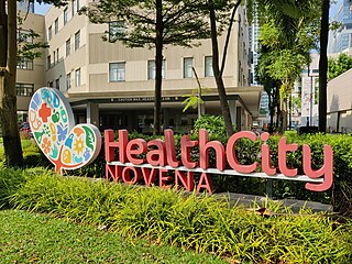
Health City Novena is an integrated healthcare hub located in Novena, Singapore. It anchors the country's Central Regional Health System. By co-locating healthcare services along the spectrum from acute care through rehabilitation to long term care, it aims to enhance collaboration among healthcare institutions.

