Novomoskovsk is a city and the administrative center of Novomoskovsky District in Tula Oblast, Russia, located at the source of the Don and Shat Rivers. Population: 131,386 (2010 Census); 134,081 (2002 Census); 146,302 (1989 Census); 143,000 (1974); 107,000 (1959); 76,000 (1939).

Bogoroditsk is a town and the administrative center of Bogoroditsky District in Tula Oblast, Russia, located on the Upyorta River, a tributary of the Upa. Population: 31,897 (2010 Census); 30,884 (2002 Census); 33,552 (1989 Census).
Donskoy is a town in Tula Oblast, Russia, located in the upper streams of the Don River, 65 kilometers (40 mi) southeast of Tula. Population: 64,552 (2010 Census); 32,745 (2002 Census); 36,158 (1989 Census).

Bogoroditsky District is an administrative district (raion), one of the twenty-three in Tula Oblast, Russia. As a municipal division, it is incorporated as Bogoroditsky Municipal District. It is located in the east of the oblast. The area of the district is 957 square kilometers (369 sq mi). Its administrative center is the town of Bogoroditsk. Population: 51,643 ; 11,543 (2002 Census); 15,002 (1989 Census). The population of Bogoroditsk accounts for 61.8% of the district's total population.

Chernsky District is an administrative district (raion), one of the twenty-three in Tula Oblast, Russia. As a municipal division, it is incorporated as Chernsky Municipal District. It is located in the southwest of the oblast. The area of the district is 1,614 square kilometers (623 sq mi). Its administrative center is the urban locality of Chern. Population: 20,476 ; 23,006 (2002 Census); 22,605 (1989 Census). The population of Chern accounts for 31.3% of the district's total population.

Dubensky District is an administrative district (raion), one of the twenty-three in Tula Oblast, Russia. Within the framework of municipal divisions, it is incorporated as Dubensky Municipal District. It is located in the northwest of the oblast. The area of the district is 799 square kilometers (308 sq mi). Its administrative center is the urban locality of Dubna. Population: 14,618 ; 15,011 (2002 Census); 15,130 (1989 Census). The population of Dubna accounts for 40.9% of the district's total population.

Kamensky District is an administrative district (raion), one of the twenty-three in Tula Oblast, Russia. As a municipal division, it is incorporated as Kamensky Municipal District. It is located in the south of the oblast. The area of the district is 795 square kilometers (307 sq mi). Its administrative center is the rural locality of Arkhangelskoye. Population: 9,548 ; 10,720 (2002 Census); 11,007 (1989 Census). The population of Arkhangelskoye accounts for 25.0% of the district's total population.

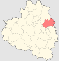
Kimovsky District is an administrative district (raion), one of the twenty-three in Tula Oblast, Russia. As a municipal division, it is incorporated as Kimovsky Municipal District. It is located in the east of the oblast. The area of the district is 1,112 square kilometers (429 sq mi). Its administrative center is the town of Kimovsk. Population: 42,853 ; 17,116 (2002 Census); 20,480 (1989 Census). The population of Kimovsk accounts for 66.5% of the district's total population.

Kireyevsky District is an administrative district (raion), one of the twenty-three in Tula Oblast, Russia. Within the framework of municipal divisions, it is incorporated as Kireyevsky Municipal District. It is located in the center of the oblast. The area of the district is 931 square kilometers (359 sq mi). Its administrative center is the town of Kireyevsk. Population: 75,142 ; 79,142 (2002 Census); 93,073 (1989 Census). The population of Kireyevsk accounts for 34.0% of the district's total population.

Kurkinsky District is an administrative district (raion), one of the twenty-three in Tula Oblast, Russia. As a municipal division, it is incorporated as Kurkinsky Municipal District. It is located in the southeast of the oblast. The area of the district is 949.25 square kilometers (366.51 sq mi). Its administrative center is the urban locality of Kurkino. Population: 10,830 ; 13,077 (2002 Census); 15,457 (1989 Census). The population of Kurkino accounts for 50.0% of the district's total population.
Leninsky District is an administrative district (raion), one of the twenty-three in Tula Oblast, Russia. It is located in the northern central part of the oblast. The area of the district is 1,351.21 square kilometers (521.71 sq mi). Its administrative center is the rural locality of Leninsky. Population: 63,355 ; 64,412 (2002 Census); 70,013 (1989 Census). The population of the administrative center accounts for 11.1% of the district's total population.

Plavsky District is an administrative district (raion), one of the twenty-three in Tula Oblast, Russia. As a municipal division, it is incorporated as Plavsky Municipal District. It is located in the southwestern central part of the oblast. The area of the district is 1,024.6 square kilometers (395.6 sq mi). Its administrative center is the town of Plavsk. Population: 27,778 ; 29,499 (2002 Census); 29,484 (1989 Census). The population of Plavsk accounts for 58.2% of the district's total population.

Shchyokinsky District is an administrative district (raion), one of the twenty-three in Tula Oblast, Russia. Within the framework of municipal divisions, it is incorporated as Shchyokinsky Municipal District. It is located in the center of the oblast. The area of the district is 1,393.4 square kilometers (538.0 sq mi). Its administrative center is the town of Shchyokino. Population: 106,595 ; 43,064 (2002 Census); 48,434 (1989 Census). The population of the administrative center accounts for 54.5% of the district's total population.

Tyoplo-Ogaryovsky District is an administrative district (raion), one of the twenty-three in Tula Oblast, Russia. As a municipal division, it is incorporated as Tyoplo-Ogaryovsky Municipal District. It is located in the south of the oblast. The area of the district is 1,014 square kilometers (392 sq mi). Its administrative center is the urban locality of Tyoploye. Population: 12,705 ; 14,111 (2002 Census); 15,493 (1989 Census). The population of Tyoploye accounts for 40.3% of the district's total population.

Uzlovsky District is an administrative district (raion), one of the twenty-three in Tula Oblast, Russia. Within the framework of municipal divisions, it is incorporated as Uzlovsky Municipal District. It is located in the east of the oblast. The area of the district is 567 square kilometers (219 sq mi). Its administrative center is the town of Uzlovaya. Population: 85,173 ; 11,046 (2002 Census); 13,284 (1989 Census). The population of Uzlovaya accounts for 64.9% of the district's total population.

Venyovsky District is an administrative district (raion), one of the twenty-three in Tula Oblast, Russia. Within the framework of municipal divisions, it is incorporated as Venyovsky Municipal District. It is located in the northeast of the oblast. The area of the district is 1,620 square kilometers (630 sq mi). Its administrative center is the town of Venyov. Population: 33,940 ; 37,612 (2002 Census); 38,527 (1989 Census). The population of Venyov accounts for 44.9% of the district's total population.
Volovsky District is an administrative district (raion), one of the twenty-three in Tula Oblast, Russia. As a municipal division, it is incorporated as Volovsky Municipal District. It is located in the southeast of the oblast. The area of the district is 1,080 square kilometers (420 sq mi). Its administrative center is the urban locality of Volovo. Population: 13,596 ; 15,957 (2002 Census); 18,419 (1989 Census). The population of Volovo accounts for 28.3% of the district's total population.

Zaoksky District is an administrative district (raion), one of the twenty-three in Tula Oblast, Russia. As a municipal division, it is incorporated as Zaoksky Municipal District. It is located in the north of the oblast. The area of the district is 918.4 square kilometers (354.6 sq mi). Its administrative center is the urban locality of Zaoksky. Population: 22,368 ; 19,406 (2002 Census); 20,429 (1989 Census). The population of the administrative center accounts for 31.8% of the district's total population.

Arsenyevo is an urban locality and the administrative center of Arsenyevsky District of Tula Oblast, Russia. Population: 4,803 (2010 Census); 5,995 (2002 Census); 5,773 (1989 Census).
Arkhangelskoye is a rural locality and the administrative center of Kamensky District of Tula Oblast, Russia. Population: 2,391 (2010 Census); 2,768 (2002 Census); 2,956 (1989 Census).