Related Research Articles

Pago Pago is the territorial capital of American Samoa. It is in Maoputasi County on the main island of American Samoa, Tutuila. It is home to one of the deepest natural deepwater harbors in the South Pacific Ocean, sheltered from wind and rough seas, and strategically located. The harbor is also one of the best protected in the South Pacific, which gives American Samoa a natural advantage with respect to landing fish for processing. Tourism, entertainment, food, and tuna canning are its main industries. Pago Pago was the world's fourth largest tuna processor as of 1993. It was home to two of the largest tuna companies in the world: Chicken of the Sea and StarKist, which exported an estimated $445 million in canned tuna to the U.S. mainland. It is the number one port in the U.S. in terms of value of fish landed - about $200,000,000 annually.

Upolu is an island in Samoa, formed by a massive basaltic shield volcano which rises from the seafloor of the western Pacific Ocean. The island is 75 kilometres long and 1,125 square kilometres in area, making it the second largest of the Samoan Islands geographically. With approximately 145,000 people, it is by far the most populated of the Samoan Islands. Upolu is situated to the southeast of Savai'i, the "big island". Apia, the capital, is in the middle of the north coast, with Faleolo International Airport at the western end of the island. The island has not had any historically recorded eruptions, although three lava flows date back only a few hundred to a few thousand years.

The Samoan Islands are an archipelago covering 3,030 km2 (1,170 sq mi) in the central South Pacific, forming part of Polynesia and the wider region of Oceania. Administratively, the archipelago comprises all of the Independent State of Samoa and most of American Samoa. The nearest land masses of the two Samoan jurisdictions are separated by 64 km (40 mi) of ocean.

Samoa is made up of eleven itūmālō. These are the traditional eleven districts that were established well before European arrival. Each district has its own constitutional foundation (faavae) based on the traditional order of title precedence found in each district's faalupega.

Nu'utele is an island which consists of a volcanic tuff ring situated 1.3 km off the eastern end of Upolu island, Samoa. It is the largest of the four Aleipata Islands, at 1.08 km2.

Aunu'u is a small volcanic island off the southeastern shore of Tutuila in American Samoa. It has a land area of 374.83 acres and a 2000 census population of 476 persons. Politically it is a part of the Eastern District, one of the primary divisions of American Samoa. The island is located in Sa'Ole County.
Lauli'i is a village on the island of Upolu in Samoa. It is located on the central north coast of the island to the east of the capital Apia. Lauli'i is part of Vaimauga East Electoral Constituency which forms part of the larger political district of Tuamasaga.

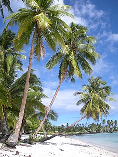
The Aleipata Islands is a group of four uninhabited islands off the eastern end of Upolu Island, Samoa, with an aggregate area of 1.68 km²):

Leone is a village on the south-west coast of Tutuila Island, American Samoa. Leone was the ancient capital of Tutuila Island. Leone was also where the Samoan Islands’ first missionary, John Williams, visited on October 18, 1832. A monument in honor of Williams has been erected in front of Zion Church. Its large church was the first to be built in American Samoa. It has three towers, a carved ceiling and stained glass. Until steamships were invented, Leone was the preferred anchorage of sailing ships which did not risk entering Pago Pago Harbor. Much early contact between Samoans and Europeans took place in Leone.

Tafuna is a village on the east coast of Tutuila Island, American Samoa. It is located on a mile north of Pago Pago International Airport and one mile south of Nu'uuli, American Samoa. The Ottoville district is a part of Tafuna. Near the Catholic church at Ottoville is an archeological park containing a well-preserved ancient Polynesian mound as well as a rainforest reserve. Tafuna is located on the Tafuna Plain, which is the largest flatland on the island of Tutuila.
Poutasi is a village on the south east coast of Upolu island in Samoa. The population was 379 in the 2006 Census. The village is part of Falealili Electoral Constituency in the larger political district of Atua. Poutasi was extensively damaged by the 2009 Samoa earthquake and tsunami.
Lefaga is a village district on the south west coast of the island of Upolu in Samoa. The American movie Return to Paradise (1953), starring Gary Cooper was filmed at Matautu village in Lefaga. The 50th anniversary celebrations of the making of the movie took place in Lefaga in November 2003.
Nu'ulua, not to be confused with Nu'ulua 200 meters west of Ofu, is an island in Samoa in the Aleipata Islands situated more than 1.3 km from the eastern end of Upolu in Samoa.
Gagaifo o le Vao is a village on the island of Upolu in Samoa. It is in the political district of A'ana.
Matatufu is a small village on south east end of Upolu island in Samoa. The village is part of Lotofaga Electoral Constituency which is within the larger political district of Atua.
Luatuanu'u is a village situated on the east side of Upolu island in Samoa. The village is part of Anoamaa West Electoral Constituency which is within the larger political district of Atua.
Ottoville is a subdivision or district within the village of Tafuna, American Samoa.
References
- ↑ "An Introduction to Samoan Custom by F.J.H. Grattan". New Zealand Electronic Centre, Victoria University of Wellington. Retrieved 15 December 2009.
- ↑ Stanley, David (2004). Moon Handbooks South Pacific. David Stanley. p. 520. ISBN 1-56691-411-6 . Retrieved 16 November 2009.
Nu'usafe'e Island.
Traditional center: Lufilufi | ||
| Villages | 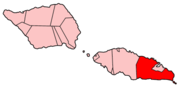 | |
| Landmarks | ||
| Islands |
| |
| Environment | ||
| Electoral constituencies: Faipule Districts |
| |
Coordinates: 14°03′S171°41′W / 14.050°S 171.683°W
| This article about a geographical location in Samoa is a stub. You can help Wikipedia by expanding it. |