
Nash is a village and also a civil parish in Buckinghamshire, England, within the Buckinghamshire Council unitary authority area. It is in the north of the county, about 5 miles (8.0 km) south-west of Milton Keynes and 4 miles (6.4 km) east of Buckingham. According to the 2011 census, the population total of Nash was 417.
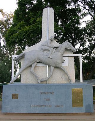
Goondiwindi is a rural town and locality in the Goondiwindi Region, Queensland, Australia. It is on the border of Queensland and New South Wales. In the 2016 census, Goondiwindi had a population of 6,355 people.

Carina is a suburb in the City of Brisbane, Queensland, Australia. In the 2016 census, Carina had a population of 11,019 people.

Milton-under-Wychwood is an English village and civil parish about 4 miles (6.4 km) north of Burford, Oxfordshire, just off the A361 road between Burford and Chipping Norton. The 2011 Census recorded the parish's population as 1,648.

Chinchilla is a rural town and locality in the Western Downs Region, Queensland, Australia. In the 2021 census, the locality of Chinchilla had a population of 7,068 people.

Miles is a rural town and locality in the Western Downs Region, Queensland, Australia. In the 2016 census, the locality of Miles had a population of 1,746 people.
Condamine is a rural town and locality in the Western Downs Region, Queensland, Australia. In the 2016 census, the locality of Condamine had a population of 384 people.

Goroke is a town in the Wimmera region of Victoria. The town is located in the Shire of West Wimmera local government area, 370 kilometres (230 mi) north west of the state capital, Melbourne. At the 2016 census, Goroke recorded a population of 299.

The County of Lowan is one of the 37 counties of Victoria which are part of the cadastral divisions of Australia, used for land titles. The northern boundary of the county is at 36°S. Larger towns include Dimboola, Edenhope and Kaniva. The county was proclaimed in 1871 together with the other counties of the Wimmera Land District.
Goroke P-12 College is a public school in Goroke, Victoria, Australia.

Minimay is a small town located in Victoria, Australia. The town is in the Shire of West Wimmera 25 kilometres (25,000 m) from the South Australian border, about halfway between Melbourne and Adelaide. At the 2016 census, Minimay and the surrounding area recorded a population of 84. A signpost outside the town lists the town's population at 9.

Gymbowen is a township in the Shire of West Wimmera of Victoria, Australia. Gymbowen recorded a population of 52 at the 2016 census.

Guluguba is a rural town and locality in the Western Downs Region, Queensland, Australia. In the 2016 census, the locality of Guluguba had a population of 109 people.

Spring Creek is a rural locality split between the Toowoomba Region and the Southern Downs Region, Queensland, Australia. In the 2016 census, Spring Creek had a population of 194 people.
Cushnie is a rural locality in the South Burnett Region, Queensland, Australia.
Moolboolaman is a rural locality in the Bundaberg Region, Queensland, Australia. In the 2016 census, Moolboolaman had a population of 434 people.
Brymaroo is a rural locality in the Toowoomba Region, Queensland, Australia. In the 2016 census Brymaroo had a population of 140 people.

Lawgi Dawes is a rural locality in the Shire of Banana, Queensland, Australia. In the 2016 census, Lawgi Dawes had a population of 144 people. It contains the neighbourhood of Lawgi, a former town.
Upper Pinelands is a rural locality in the Toowoomba Region, Queensland, Australia. In the 2016 census, Upper Pinelands had a population of 33 people.
Jackson North is a rural locality in the Maranoa Region, Queensland, Australia. In the 2016 census Jackson North had a population of 61 people.

