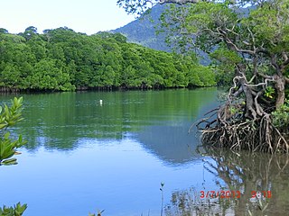
Oak Beach, Queensland

Last updated

Oak Beach
Queensland
Australia Queensland location map.svg
Red pog.svg
Oak Beach
Coordinates 16°36′01″S145°31′18″E / 16.6002°S 145.5216°E / -16.6002; 145.5216 Coordinates: 16°36′01″S145°31′18″E / 16.6002°S 145.5216°E / -16.6002; 145.5216
Population195 (2016 census) [1]
 • Density27.08/km2 (70.1/sq mi)
Postcode(s) 4877
Area7.2 km2 (2.8 sq mi)
LGA(s) Shire of Douglas
State electorate(s) Cook
Federal Division(s) Leichhardt
Localities around Oak Beach:
Mowbray Mowbray Coral Sea
Mowbray Oak Beach Coral Sea
Mowbray Mowbray Coral Sea

Oak Beach is a coastal town and a locality in the Shire of Douglas, Queensland, Australia. [2] [3] In the 2016 census, Oak Beach had a population of 195 people. [1]

Suburbs and localities are the names of geographic subdivisions in Australia, used mainly for address purposes. The term locality is used in rural areas, while the term suburb is used in urban areas. Australian postcodes closely align with the boundaries of localities and suburbs.

Shire of Douglas Local government area in Queensland, Australia

The Shire of Douglas is a local government area in Far North Queensland. It is located on the coast north of the city of Cairns. The shire, administered from the town of Mossman, covers an area of 2,436.7 square kilometres (940.8 sq mi), and existed as a local government entity from 1880 until 2008, when it was amalgamated with the City of Cairns to become the Cairns Region. Following a poll in 2013, the Shire of Douglas was re-established on 1 January 2014.

Queensland North-east state of Australia

Queensland is the second-largest and third-most populous state in the Commonwealth of Australia. Situated in the north-east of the country, it is bordered by the Northern Territory, South Australia and New South Wales to the west, south-west and south respectively. To the east, Queensland is bordered by the Coral Sea and Pacific Ocean. To its north is the Torres Strait, with Papua New Guinea located less than 200 km across it from the mainland. The state is the world's sixth-largest sub-national entity, with an area of 1,852,642 square kilometres (715,309 sq mi).

Contents

Geography

Oak Beach is bounded by the Coral Sea to east and completely surrounded by the locality of Mowbray on all its land boundaries. [4]

Coral Sea A marginal sea of the South Pacific off the northeast coast of Australia

The Coral Sea is a marginal sea of the South Pacific off the northeast coast of Australia, and classified as an interim Australian bioregion. The Coral Sea extends 2,000 kilometres (1,200 mi) down the Australian northeast coast.

Mowbray, Queensland Suburb of Shire of Douglas, Queensland, Australia

Mowbray is a coastal locality in the Shire of Douglas, Queensland, Australia. In the 2016 census, Mowbray had a population of 321 people.

History

The locality was named and bounded on 8 September 2000. [3]

Related Research Articles

Port Douglas Town in Queensland, Australia

Port Douglas is a coastal town and locality in the Shire of Douglas, Queensland, Australia,, approximately 70 km (40 mi) north of Cairns. In the 2016 census, Port Douglas had a population of 3,504 people. The town's population can often double, however, with the influx of tourists during the peak tourism season from May to September. The town is named in honour of a former Premier of Queensland, John Douglas. Port Douglas developed quickly based on the mining industry. Other parts of the area were established with timber cutting occurring in the area surrounding the Daintree River and with settlement starting to occur on lots around the Mossman River by 1880.

Forrest Beach, Queensland Suburb of Shire of Hinchinbrook, Queensland, Australia

Forrest Beach is a small coastal locality in the Shire of Hinchinbrook, Queensland, Australia, while Allingham is the coastal town within the locality. In the 2016 census, Forrest Beach had a population of 1,254 people.

Wangetti, Queensland Town in Queensland, Australia

Wangetti is a coastal town and a locality in the Shire of Douglas, Queensland, Australia. In the 2016 census, Wangetti had a population of 50 people.

Craiglie Suburb of Shire of Douglas, Queensland, Australia

Craiglie is a coastal rural locality in the Shire of Douglas, Queensland, Australia. In the 2016 census, Craiglie had a population of 954 people.

Killaloe, Queensland Suburb of Shire of Douglas, Queensland, Australia

Killaloe is a coastal rural locality in the Shire of Douglas, Queensland, Australia. In the 2016 census, Killaloe had a population of 116 people.

Armstrong Beach, Queensland Town in Queensland, Australia

Armstrong Beach is a coastal town and a locality in the Mackay Region, Queensland, Australia. In the 2016 census, Armstrong Beach had a population of 863 people.

Campwin Beach, Queensland Town in Queensland, Australia

Campwin Beach is a coastal town and locality in the Mackay Region, Queensland, Australia. In the 2016 census, Campwin Beach had a population of 517 people.

Horseshoe Lagoon, Queensland Suburb of Shire of Burdekin, Queensland, Australia

Horseshoe Lagoon is a rural locality in the Shire of Burdekin, Queensland, Australia. In the 2016 census, Horseshoe Lagoon had a population of 217 people.

Upper Haughton, Queensland Suburb of Shire of Burdekin, Queensland, Australia

Upper Haughton is a locality in the Shire of Burdekin, Queensland, Australia. In the 2016 census, Upper Haughton had a population of 75 people.

Swans Lagoon, Queensland Suburb of Shire of Burdekin, Queensland, Australia

Swans Lagoon is a locality in the Shire of Burdekin, Queensland, Australia. In the 2016 census, Swans Lagoon had no population.

Wangaratta, Queensland Suburb of Shire of Burdekin, Queensland, Australia

Wangaratta is a locality in the Shire of Burdekin, Queensland, Australia. In the 2016 census, Wangaratta had a population of 27 people.

Groper Creek, Queensland Town in Queensland, Australia

Groper Creek is a coastal town and a locality in the Shire of Burdekin, Queensland, Australia. In the 2016 census, Groper Creek had a population of 62 people.

Mount Kelly, Queensland Suburb of Shire of Burdekin, Queensland, Australia

Mount Kelly is a rural locality in the Shire of Burdekin, Queensland, Australia. In the 2016 census, Mount Kelly had a population of 280 people.

Newell, Queensland Town in Queensland, Australia

Newell is a coastal town and rural locality in the Shire of Douglas, Queensland, Australia. In the 2016 census, Newell had a population of 336 people.

Cooya Beach, Queensland Town in Queensland, Australia

Cooya Beach is a coastal town and locality in the Shire of Douglas, Queensland, Australia. In the 2016 census, Cooya Beach had a population of 546 people.

Dagmar, Queensland Suburb of Shire of Douglas, Queensland, Australia

Dagmar is a locality in the Shire of Douglas, Queensland, Australia. In the 2016 census, Dagmar had a population of 0 people.

Diwan, Queensland Suburb of Shire of Douglas, Queensland, Australia

Diwan is a coastal locality in the Shire of Douglas, Queensland, Australia. In the 2016 census, Diwan had a population of 153 people.

Thornton Beach, Queensland Town in Queensland, Australia

Thornton Beach is a coastal town and locality in the Shire of Douglas, Queensland, Australia. In the 2016 census, Thornton Beach had a population of 5 people.

Degarra, Queensland Suburb of Shire of Douglas, Queensland, Australia

Degarra is a locality in the Shire of Douglas, Queensland, Australia. In the 2016 census, Degarra had a population of 110 people.

References

  1. 1 2 Australian Bureau of Statistics (27 June 2017). "Oak Beach (SSC)". 2016 Census QuickStats. Retrieved 20 October 2018. Blue pencil.svg
  2. "Oak Beach - town in Shire of Douglas (entry 24978)". Queensland Place Names. Queensland Government . Retrieved 27 November 2018.
  3. 1 2 "Oak Beach - locality in Shire of Douglas (entry 48816)". Queensland Place Names. Queensland Government . Retrieved 27 November 2018.
  4. "Queensland Globe". State of Queensland . Retrieved 3 June 2019.