
Coahuila, formally Coahuila de Zaragoza, officially the Free and Sovereign State of Coahuila de Zaragoza, is one of the 32 states of Mexico.
Coahuila is a state in Northeast Mexico that is divided into 38 municipalities. According to the 2020 Mexican census, Coahuila is the 15th most populous state with 3,146,771 inhabitants and the third largest by land area spanning 151,846.16 square kilometres (58,628.13 sq mi).
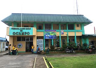
Ocampo, officially the Municipality of Ocampo, is a 1st class municipality in the province of Camarines Sur, Philippines. According to the 2020 census, it has a population of 51,073 people.
Melchor Ocampo is a municipality located in the Mexican state of Nuevo León. It is named after Don Melchor Ocampo, who was Foreign Minister during the government of Benito Juárez.
Sabinas is a city in Sabinas Municipality of the same name located in the northeastern quadrant of the state of Coahuila in Mexico. As of the 2005 census the city had a population of 47,933, while the municipality of which the city serves as municipal seat had a population of 53,042. The municipality has an area of 2,345.2 km². Its only other significant communities are the towns of Cloete and Agujita.
Matamoros is a city located in the southwestern part of the Mexican state of Coahuila; it serves as the seat of the surrounding municipality of the same name. It lies directly east of the larger city of Torreón and is a part of the Comarca Lagunera, a larger metropolitan area that includes the municipality of Torreón in Coahuila in addition to the municipalities of Gómez Palacio and Lerdo in the adjacent state of Durango.
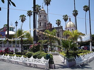
Ocampo is a city located in the northwest region of the Mexican state of Guanajuato. The municipality has an area of 1,019.49 square kilometres and is bordered and to the south and east by San Felipe, to the north by the state of San Luis Potosí, to the west by the state of Jalisco. The municipality had a population of 23,500 inhabitants according to the 2010 census.

Hidalgo or Villa Hidalgo is a community located in the Mexican state of Coahuila. It is the municipal seat of Hidalgo Municipality. According to the INEGI census of 2010, Hidalgo has a population of 1,638 inhabitants. Its elevation is 150 meters above sea level.

Concepción del Oro is one of the 58 municipalities in the Mexican state of Zacatecas. It is located on the northern part of the state and it is bounded by the municipalities of Mazapil and El Salvador; it also lies next to the states of Coahuila and San Luis Potosí. The municipality covers a total surface area of 2,559 square kilometers (988 sq mi).

Manuel Benavides is one of the 67 municipalities of Chihuahua, in northern Mexico. The municipal seat lies at Manuel Benavides village. The municipality covers an area of 3,191.5 km².

Acuña is one of the 38 municipalities of Coahuila, in north-eastern Mexico. The municipal seat lies at Ciudad Acuña, which contained over 98% of the municipality's population in 2010. The municipality covers an area of 11,487.7 km2 and is located on the international border between Mexico and the USA, here formed by the Río Bravo del Norte, adjacent to the U.S. state of Texas.

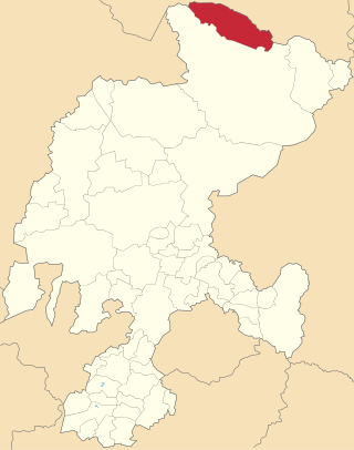
Ocampo is one of the 38 municipalities of Coahuila, in north-eastern Mexico, and the largest by area. The municipal seat lies at Ocampo. The municipality covers an area of 26,433 km² and is located on the international border between Mexico and the USA, here formed by the Río Bravo del Norte, adjacent to the U.S. state of Texas.

Churintzio is a municipality in the Mexican state of Michoacán, located 104 kilometres (65 mi) northwest of the state capital of Morelia.

Indaparapeo is a municipality in the Mexican state of Michoacán, located approximately 25 kilometres (16 mi) east of the state capital of Morelia.
Morelos is a municipality in the Mexican state of Michoacán, located approximately 40 kilometres (25 mi) northwest of the state capital of Morelia.

Tzitzio is a municipality in the Mexican state of Michoacán, located approximately 30 kilometres (19 mi) southeast of the state capital of Morelia.
Tanhuato is a municipality in the Mexican state of Michoacán, located approximately 135 kilometres (84 mi) northwest of the state capital of Morelia.

Vista Hermosa is a municipality in the Mexican state of Michoacán, located approximately 150 kilometres (93 mi) northwest of the state capital of Morelia.
Melchor Ocampo is a municipality in the Mexican state of Zacatecas, located approximately 250 kilometres (160 mi) north of Zacatecas City, the state capital. It is named after Melchor Ocampo.

