Ogallah, Kansas | |
|---|---|
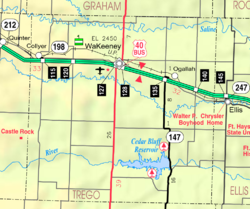 | |
 Ogallah  Ogallah | |
| Coordinates: 38°59′29″N99°43′56″W / 38.99139°N 99.73222°W [1] | |
| Country | United States |
| State | Kansas |
| County | Trego |
| Founded | 1870s |
| Named after | Oglala Lakota tribe |
| Elevation | 2,336 ft (712 m) |
| Population | |
• Total | 28 |
| Time zone | UTC-6 (CST) |
| • Summer (DST) | UTC-5 (CDT) |
| ZIP code | 67656 |
| Area code | 785 |
| FIPS code | 20-52250 [1] |
| GNIS ID | 485296 [1] |
Ogallah is a census-designated place (CDP) in Trego County, Kansas, United States. [1] As of the 2020 census, the population was 28. [2] It is located approximately 7 miles east of WaKeeney.
