Yvelines is a department in the western part of the Île-de-France region in Northern France. In 2019, it had a population of 1,448,207. Its prefecture is Versailles, home to the Palace of Versailles, the principal residence of the King of France from 1682 until 1789, a UNESCO World Heritage Site since 1979. Yvelines' subprefectures are Saint-Germain-en-Laye, Mantes-la-Jolie and Rambouillet.

Oise is a department in the north of France. It is named after the river Oise. Inhabitants of the department are called Oisiens or Isariens, after the Latin name for the river, Isara. It had a population of 829,419 in 2019.
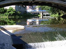
The Canal de la Sambre à l'Oise is a canal in northern France. It forms a connection between the canalised river Sambre at Landrecies and the Oise at La Fère. The canal is 71 kilometres (44 mi) long, and has 38 locks. The junction made at La Fère is with a branch of the Canal de Saint-Quentin, while the Canal latéral à l'Oise is joined 10.5 km further downstream at Chauny. It was used by the standard Freycinet-gauge péniches, 38.50 metres (126.3 ft) long, and 5.05 metres (16.6 ft) in beam, carrying up to 250 tonnes. The canal, also a popular waterway for boats heading south from the Netherlands and Belgium to the central French waterways, had to be closed in 2006 when two aqueducts were found to be in danger of failing. Funding has been put in place by the owner, Voies Navigables de France, and the local authorities, with support from the State. The canal was reopened in July 2021.
The Sambre is a river in northern France and in Wallonia, Belgium. It is a left-bank tributary of the Meuse, which it joins in the Wallonian capital Namur.

The Aisne is a river in northeastern France. It is a left tributary of the Oise. It gave its name to the French department of Aisne. It was known in the Roman period as Axona.

This Summary and map of the 2005 French riots is to clearly show the spread of the 2005 French riots.

Conflans-Sainte-Honorine is a commune in the Yvelines department in the Île-de-France region in north-central France. It is located in the northwestern suburbs of Paris, 24.2 km (15.0 mi) from the center of Paris.
Transilien Paris-Saint-Lazare is one of the sectors in the Paris Transilien suburban rail network. The trains on this sector depart from Gare Saint-Lazare in central Paris and serve the north and north-west of Île-de-France region with Transilien lines "J" and "L". Transilien services from Paris to Saint-Lazare are part of the SNCF Saint-Lazare rail network.

Saint Honorina was a 3rd-century virgin martyr of Gallo-Roman northern France, venerated as a saint in the Catholic and Eastern Orthodox Churches. Believed to have been killed in the first years of the 4th century during the persecutions of Diocletian, very little is known of her life, apart from her reputed martyrdom for maintaining her Christian faith.

Conflans–Fin d'Oise is a railway station serving Conflans-Sainte-Honorine. It is a two-level station situated on the lines from Saint-Lazare to Cergy-le-Haut and from Saint-Lazare to Mantes-la-Jolie via Conflans-Sainte-Honorine.
Oise is a department in the north of France.

The Canal du Nord is a 95-kilometre (59 mi) long canal in northern France. The canal connects the Canal latéral à l'Oise at Pont-l'Évêque to the Sensée Canal at Arleux. The French government, in partnership with coal-mining companies in the Nord and Pas-de-Calais departments, developed the canal to help French coal mining companies withstand foreign competition. Construction of the canal began in 1908 but halted in 1914, because of the First World War. The war caused widespread destruction of the canal and the French government made no attempt to resume construction until 1959. Construction recommenced in 1960 and the waterway opened to the public in 1965. The Canal du Nord and the Canal de Saint-Quentin may be supplanted by the Seine–Nord Europe Canal, a projected high capacity link between the Oise River at Janville and the high capacity Dunkirk-Escaut Canal.
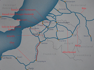
The Seine–Nord Europe Canal is a planned high-capacity canal in France that would link the Oise River at Compiègne with the Dunkirk-Scheldt Canal, east of Arleux. It is the French part of a proposed Seine-Scheldt canal that would ultimately connect the Rhine and Seine basins inland. The stated objective is to expand trade flows in a fuel-efficient and ecologically friendly manner between the Seine basin and Belgium, Germany and the Netherlands, while reducing saturation on the A1 motorway in France and reducing the CO2 emissions in the transport sector within this corridor.
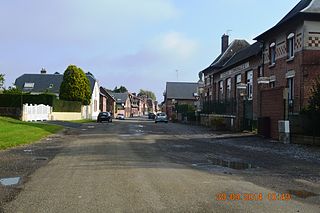
Alaincourt is a commune in the department of Aisne in the Hauts-de-France region of northern France.

Butry-sur-Oise is a commune in the Val-d'Oise department in Île-de-France in northern France. Valmondois station, situated in the commune, has rail connections to Persan, Creil, Pontoise and Paris.
The Canal latéral à l'Aisne is a canal in northern France, which connects the Canal des Ardennes at Vieux-lès-Asfeld to the canalised river Aisne at Condé-sur-Aisne. It is 51.3 km (31.9 mi) long, with 8 locks. It runs alongside the Aisne. It has junctions with the Canal de l'Aisne à la Marne at Berry-au-Bac and with the Canal de l'Oise à l'Aisne in Bourg-et-Comin.

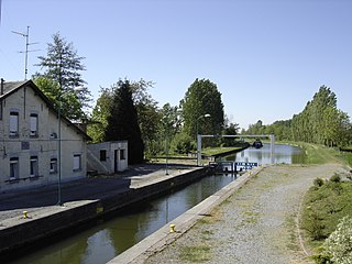
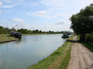
The Canal latéral à l'Oise is a canal in northern France that, along with the river Oise, connects the Canal de Saint-Quentin at Chauny to the Seine at Conflans-Sainte-Honorine. See under the river Oise for the continuation of the route; the junction is made downstream of the lock at Janville 49.45750°N 2.85933°E. When a canal is latéral, it follows the course of the river it is named after but in a separate excavated channel. The route described below is the 34 km of canal parallel to the river Oise and 103.5 km of the canalised river Oise.
The railway from Creil to Jeumont is an important French 187-kilometre long railway line, that connects Creil, a northern suburb of Paris, to Jeumont on the Belgian border. It was opened in several stages between 1847 and 1855. The opening of the LGV Nord high speed line from Paris to Lille in 1993 has decreased its importance for passenger traffic.

The Je Sers, is a chapel-boat for boatmen, dedicated to Saint-Nicholas. It is moored at The Quai de la Republique of Conflans-Sainte-Honorine (France) and registered at the Inventaire général du patrimoine culturel.