Oklahoma State Highway 56

Last updated

Oklahoma State Highway 56.svg

State Highway 56

Seminole Nation Highway
Ok-56 path.png
Route information
Maintained by ODOT
Length86.7 mi [1]  (139.5 km)
ExistedAugust 28, 1929 [2] –present
Major junctions
South endUS 377.svgOklahoma State Highway 3E.svgOklahoma State Highway 39.svgOklahoma State Highway 99.svg US 377  / SH-3E  / SH-39  / SH-99 east of Konawa
Major intersections
North endUS 75.svg US 75 in Okmulgee
Location
Country United States
State Oklahoma
Highway system
  • Oklahoma State Highway System
US 56.svg US 56 Oklahoma State Highway 58.svg SH-58

State Highway 56 (abbreviated SH-56 or OK-56) is a state highway in the U.S. state of Oklahoma. The road serves Seminole County, Okfuskee County, and Okmulgee Counties in central and east-central Oklahoma. In Seminole County, it is also designated as the Seminole Nation Highway in honor of the contributions the Seminole Nation has made to the state of Oklahoma. [2]

Contents

SH-56 begins at an intersection with US-377 four miles (6 km) east of Konawa, [3] and extends to US-75 in Okmulgee. The highway's total length is 86.7 miles (139.5 km). [1]

SH-56 was first added to the state highway system in 1929. It was gradually extended to its present length between then and 1942. [2]

Route description

Northbound SH-56 as seen from the SH-9 junction OK-56 from OK-9.jpg
Northbound SH-56 as seen from the SH-9 junction

SH-56 begins at the junction of SH-39 and US-377/SH-3E/SH-99 four miles (6 km) east of Konawa. From here, the highway and heads east, curving through the hilly terrain of southeastern Seminole County. [4] The highway passes through the town of Sasakwa 10 miles (16 km) east of US-377. [3] At Sasakwa, the road turns north, crossing the Little River northeast of town and generally paralleling the Seminole–Hughes County county line.

The highway then bisects the town of Wewoka, intersecting US-270 and concurring with its business loop. SH-56 also serves as the eastern terminus of SH-59 in Wewoka. North of the town, SH-56 intersects with SH-9. The highway continues north, intersecting SH-99A in Cromwell and interchanging with I-40 near the unincorporated community of Schoolton. After crossing I-40, SH-56 makes a long arc to the east, bringing it into Okfuskee County. [3]

Just east of the county line, SH-56 bridges the North Canadian River. South of Castle, the road intersects with SH-48. SH-56 then proceeds east into Okemah, the county seat, where it has a short concurrency with both US-62 and SH-27. The highway continues east from town, then turns north, before turning back to the east to pass through the unincorporated settlement of Okfuskee. East of Okfuskee, the highway enters Okmulgee County.

In Okmulgee County, SH-56 skirts the northern edge of Okmulgee Lake and serves Dripping Springs State Park. East of the lake, it passes through Okmulgee Wildlife Refuge and Deep Fork National Wildlife Refuge. [4] It then enters the city of Okmulgee. There, SH-56 comes to an end at US-75. However, there is a separate loop route segment of SH-56 that starts from a more northerly point on US-75 and runs a short distance to US-62. [5]

History

State Highway 56 traces its origins to August 28, 1929, its original date of commissioning. At that time, the highway only consisted of the portion of the route extending from the SH-99 junction (then SH-48) east to Sasakwa, thence north to end at SH-3 south of Wewoka. [2] [6] The highway underwent its first extension just under two years later, on June 15, 1931, when it was extended to end at US-62 in Okemah. [2] [7] The highway was extended to Okmulgee on April 13, 1942, bringing it to its current extent. [2] [8] Other than minor realignments and establishment of the Loop route segment, the highway has undergone no further changes since 1942.

Junction list

CountyLocationmi [1] kmDestinationsNotes
Seminole 0.00.0West plate.svg
Oklahoma State Highway 39.svg
US 377.svgOklahoma State Highway 3E.svgOklahoma State Highway 99.svg SH-39 west / US 377  / SH-3E  / SH-99
Southern terminus; road continues west as SH-39
Wewoka 23.137.2US 270.svgBusiness plate.svg
US 270.svg
US 270  / US 270 Bus. begin
Eastern terminus of US-270 Bus., southern end of US-270 Bus. concurrency
24.238.9Oklahoma State Highway 59.svg SH-59 (14th Street)Eastern terminus of SH-59
25.140.4West plate.svg
Business plate.svg
US 270.svg
US 270 Bus. west
Northern end of US-270 Bus. concurrency
30.549.1Oklahoma State Highway 9.svg SH-9
Cromwell 38.662.1Oklahoma State Highway 99A.svg SH-99A
41.266.3I-40.svg I-40  Oklahoma City, Ft. Smith I-40 exit 212
Okfuskee 47.276.0Oklahoma State Highway 48.svg SH-48
Okemah 51.883.4East plate.svg
US 62.svg
South plate.svg
Oklahoma State Highway 27.svg
US 62 east / SH-27 south (Woody Guthrie Street)
Western end of US-62/SH-27 concurrency
52.183.8West plate.svg
US 62.svg
Oklahoma State Highway 27.svg US 62 west (Columbia Street) / SH-27 end
Eastern end of US-62/SH-27 concurrency, northern terminus of SH-27
Okmulgee Okmulgee 86.7139.5US 75.svg US 75 (Wood Drive)Northern terminus; road continues east as 6th Street
1.000 mi = 1.609 km; 1.000 km = 0.621 mi

Loop route

Loop plate.svg

Oklahoma State Highway 56.svg

State Highway 56 Loop

Location Okmulgee, Oklahoma
Existed1962–present

State Highway 56 Loop (also known as SH-56 Loop or more commonly, Loop 56) is a bypass route around the northeast quadrant of Okmulgee, starting from US-75 in the north of Okmulgee, running in an arc east and then south, and connecting with US-62 east of the city. [5] Although it shares its number with SH-56, it does not intersect its implied parent route. Among other functions, the highway provides access to Oklahoma State University Institute of Technology as well as the College of the Muscogee Nation. Loop 56 is 3.7 miles (6.0 km) long. [9] It was established on May 7, 1962. [2]

Loop Route Major Intersections

Loop 56 at its intersection with US-75 Loop 56 from US 75.jpg
Loop 56 at its intersection with US-75

The entire route is in Okmulgee, Okmulgee County.

mi [1] kmDestinationsNotes
0.000.00US 62.svg US 62 (New Morris Highway)Southern terminus
3.76.0US 75.svg US 75 (Wood Drive)Northern terminus; road continues west as Fairgrounds Road
1.000 mi = 1.609 km; 1.000 km = 0.621 mi

Related Research Articles

<span class="mw-page-title-main">U.S. Route 377</span> Auxiliary U.S. Highway in Texas and Oklahoma in the United States

U.S. Route 377 (US 377) is a 478-mile-long (769 km) north–south United States highway. Originally formed as a short spur to connect Denton, Texas with Fort Worth, Texas, it has since been extended to Oklahoma and Mexico.

<span class="mw-page-title-main">U.S. Route 266</span>

U.S. Route 266 is a 43.09-mile (69.35 km), east–west U.S. Numbered Highway in Okmulgee, McIntosh, and Muskogee counties in Oklahoma, United States, that connects U.S. Route 62 U.S. Route 75 in Henryetta with U.S. Route 64 in Warner. The highway no longer meets the former route of its parent, U.S. Route 66, and is closely paralleled by Interstate 40 (I-40), which replaced US 266 as the major east–west highway east of Oklahoma City during the 1960s.

<span class="mw-page-title-main">U.S. Route 270</span> Highway in the United States

U.S. Route 270 (US 270) is a spur of US 70. It travels for 643 miles (1,035 km) from Liberal, Kansas at US 54 and US 83 to White Hall, Arkansas at Interstate 530 (I-530) and US 65. It travels through the states of Arkansas, Oklahoma, and Kansas. It travels through the cities of Oklahoma City, Oklahoma, Hot Springs, Arkansas, and McAlester, Oklahoma.

<span class="mw-page-title-main">U.S. Route 177</span> Route 77 Spur

U.S. Route 177 (US-177) is a spur of U.S. Route 77. It currently runs for 233 miles (375 km) from South Haven, Kansas at US-81 to Madill, Oklahoma at US-70. It passes through the states of Kansas and Oklahoma.

<span class="mw-page-title-main">Oklahoma State Highway 66</span> Highway in Oklahoma

State Highway 66 is a 192.7-mile (310.1 km) state highway in the U.S. state of Oklahoma, beginning at U.S. Highway 81 in El Reno and ending at U.S. Highway 60 near White Oak. The highway was designated in 1985 as a replacement for the decommissioned US 66. Although most of the highway follows Historic Route 66, the highway follows US 66's final alignment, joining Interstate 44 through Tulsa and Oklahoma City, while older versions of the route follow various city streets through both cities.

<span class="mw-page-title-main">Oklahoma State Highway 9</span> Highway in Oklahoma

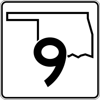
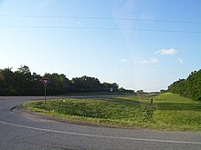
State Highway 9, abbreviated as SH-9, OK-9, or simply Highway 9, is a major east–west highway in the U.S. state of Oklahoma. Spanning across the central part of the state, SH-9 begins at the Texas state line west of Vinson, Oklahoma, and ends at the Arkansas state line near Fort Smith, Arkansas. State Highway 9 is a major highway around the Norman area. At 348.1 miles (560.2 km), SH-9 is Oklahoma's second-longest state highway.

<span class="mw-page-title-main">Oklahoma State Highway 99</span> Highway in Oklahoma

State Highway 99 (SH-99) is a north–south state highway through central Oklahoma. It runs from the Texas state line at Lake Texoma to the Kansas state line near Lake Hulah. It is 241.5 miles (388.7 km) long. The highway overlaps U.S. Highway 377 (US-377) for over half its length.

<span class="mw-page-title-main">Oklahoma State Highway 39</span>

State Highway 39, abbreviated as SH-39, is a state highway in the U.S. state of Oklahoma. It is 68.4 miles (110.1 km) in length. It runs east–west through the central part of the state, beginning at unincorporated Tabler, east of Chickasha, and ending east of Konawa. Along the way, SH-39 serves the counties of Grady, McClain, Cleveland, Pottawatomie, and Seminole. It currently has no lettered spurs.

<span class="mw-page-title-main">Oklahoma State Highway 67</span>

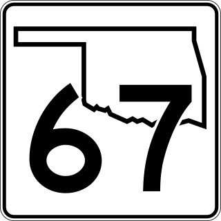
State Highway 67, abbreviated as SH-67, is a 9.94-mile-long (16.00 km) highway on the south side of Tulsa. It begins in the west at U.S. Route 75 Alternate in Kiefer and runs east along 151st St. South before ending at US-64 in Bixby. Along the way it crosses US-75 in Glenpool. It has no lettered spur routes.

The Oklahoma state highway system includes many state highways that act as short spur and connector routes off some of the U.S. highways that pass through the state. These highways generally bear the same number of the U.S. highway they connect to with a letter suffix.

<span class="mw-page-title-main">Oklahoma State Highway 59</span> Highway in Oklahoma

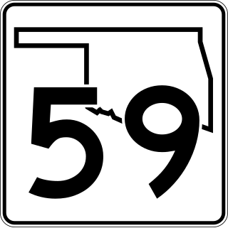
State Highway 59, abbreviated SH-59, is a 93-mile (150 km) state highway in central Oklahoma. It runs from Criner, Oklahoma in McClain Co. to Wewoka.

<span class="mw-page-title-main">Oklahoma State Highway 84</span>

State Highway 84 (SH-84) is a short state highway in Okfuskee and Hughes Counties in Oklahoma. It begins at State Highway 9 in Dustin and runs northwest to end at U.S. Highway 75 near Weleetka. It passes through Hughes County for 1.34 miles (2.16 km) and Okfuskee County for 8.51 miles (13.70 km), for a total length of 9.85 miles (15.85 km). It has no lettered spur routes.

<span class="mw-page-title-main">Oklahoma State Highway 17</span>

State Highway 17, abbreviated as SH-17, is an east–west highway in Oklahoma. It is a relatively short highway, extending for only 20.86 miles (33.57 km) from U.S. Highway 277 (US-277) in Elgin to Business US-81 in Rush Springs. It has no lettered spur routes.

<span class="mw-page-title-main">Oklahoma State Highway 16</span>

State Highway 16 is a state highway in Oklahoma. It runs in an irregular 99.2-mile west-to-east pattern through the northeastern part of the state, running from SH-33 at Drumright to SH-51 at Wagoner. There are no letter-suffixed spur highways branching from SH-16.

<span class="mw-page-title-main">Oklahoma State Highway 27</span>

State Highway 27 is a state highway in east-central Oklahoma. It has an extent of 14.7 miles (23.7 km) from south to north in Hughes and Okfuskee Counties. There are no letter-suffixed spur highways branching from SH-27.

<span class="mw-page-title-main">Oklahoma State Highway 32</span> Highway in Oklahoma

State Highway 32 is a state highway in the U.S. state of Oklahoma. The highway runs from west to east across the southern part of the state, just north of the Red River. The route begins at US-81 in Ryan and ends at US-70 in Kingston, a length of 77.3 miles (124.4 km).

<span class="mw-page-title-main">U.S. Route 62 in Oklahoma</span> Highway in Oklahoma

In Oklahoma, U.S. Highway 62 (US 62) runs diagonally across the state, from the Texas state line in far southwestern Oklahoma to the Arkansas state line near Fayetteville. US-62 spends a total of 402.48 miles (647.73 km) in the Sooner State. The highway passes through fifteen of Oklahoma's counties. Along the way the route serves two of Oklahoma's largest cities, Lawton and Oklahoma City, as well as many regionally important cities, like Altus, Chickasha, Muskogee, and Tahlequah. Despite this, US-62 has no lettered spur routes like many other U.S. routes in Oklahoma do.

<span class="mw-page-title-main">U.S. Route 70 in Oklahoma</span> Highway in Oklahoma

U.S. Route 70 is a transcontinental U.S. highway extending from Globe, Arizona to Atlantic, North Carolina. Along the way, 289.81 miles (466.40 km) of its route passes through the state of Oklahoma. Entering the state south of Davidson, the highway serves Oklahoma's southern tier before exiting the state east of Broken Bow. It serves the cities of Ardmore, Durant, Hugo, and Idabel, as well as Tillman, Cotton, Jefferson, Carter, Marshall, Bryan, Choctaw, and McCurtain counties.

<span class="mw-page-title-main">U.S. Route 412 in Oklahoma</span> Highway in Oklahoma

U.S. Route 412 is a U.S. highway in the south-central portion of the United States, connecting Springer, New Mexico to Columbia, Tennessee. A 504.11-mile (811.29 km) section of the highway crosses the state of Oklahoma, traversing the state from west to east. Entering the state southwest of Boise City, US-412 runs the length of the Oklahoma Panhandle and serves the northern portion of the state's main body, before leaving the state at West Siloam Springs. Along the way, the route serves many notable cities and towns, including Boise City, Guymon, Woodward, Enid, and the state's second-largest city, Tulsa.

<span class="mw-page-title-main">U.S. Route 75 Alternate (Beggs–Sapulpa, Oklahoma)</span>

U.S. 75 Alternate is a 30.15-mile (48.52 km) highway near Tulsa. The southern terminus is at U.S. Highway 75 and SH-16 east of Beggs. The northern terminus is signed at State Highway 66 and State Highway 97 in Sapulpa. However, the highway continues unsigned along SH-66, ending at the north terminus of the Turner Turnpike, where SH-66 merges onto the free portion of I-44. It runs parallel to US-75 for its entire length.

References

  1. 1 2 3 4 Stuve, Eric. "OK-56". OKHighways.com.[ self-published source ]
  2. 1 2 3 4 5 6 7 Oklahoma Department of Transportation. "Memorial Dedication and Revision History, SH 56". Oklahoma Department of Transportation. Retrieved 2010-05-01.
  3. 1 2 3 Official State Map (PDF) (Map) (2009–10 ed.). Oklahoma Department of Transportation. Retrieved 2010-04-30.
  4. 1 2 Oklahoma Atlas and Gazetteer (Map). 1:200,000. DeLorme. 2006.
  5. 1 2 "Okmulgee, Oklahoma". Google Maps. Retrieved October 10, 2019.
  6. Map Showing Condition of Improvement of the State Highway System (PDF) (Map) (March 1, 1930 ed.). Oklahoma State Highway Department. Retrieved 2010-05-01.
  7. Map Showing Condition of Improvement of the State Highway System (PDF) (Map) (June 1932 ed.). Oklahoma Department of Highways. Retrieved 2010-05-01.
  8. Map Showing Condition of Improvement of the State Highway System (PDF) (Map) (June 1944 ed.). Oklahoma Department of Highways. Retrieved 2010-05-01.
  9. Oklahoma Department of Transportation (n.d.). Control Section Maps: Okmulgee County (PDF) (Map). Scale not given. Oklahoma City: Oklahoma Department of Transportation. Retrieved 2010-04-30.
Template:Attached KML/Oklahoma State Highway 56
KML is from Wikidata