Olargues

Last updated • 1 min readFrom Wikipedia, The Free Encyclopedia

Olargues
Olargues vue generale.JPG
A general view of Olargues
Blason ville fr Olargues (Herault).svg
Location of Olargues
Olargues
France location map-Regions and departements-2016.svg
Red pog.svg
Olargues
Languedoc-Roussillon-Midi-Pyrenees region location map.svg
Red pog.svg
Olargues
Coordinates: 43°33′26″N2°54′55″E / 43.5572°N 2.9153°E / 43.5572; 2.9153
Country France
Region Occitania
Department Hérault
Arrondissement Béziers
Canton Saint-Pons-de-Thomières
Government
  Mayor (20202026) Jean Arcas [1]
Area
1
18.6 km2 (7.2 sq mi)
Population
 (2021) [2]
550
  Density30/km2 (77/sq mi)
Time zone UTC+01:00 (CET)
  Summer (DST) UTC+02:00 (CEST)
INSEE/Postal code
34187 /34390
Elevation148–760 m (486–2,493 ft)
(avg. 183 m or 600 ft)
1 French Land Register data, which excludes lakes, ponds, glaciers > 1 km2 (0.386 sq mi or 247 acres) and river estuaries.

Olargues (French pronunciation: [ɔlaʁɡ] ) is a commune in the Hérault department in the Occitanie region in southern France. It is a member of Les Plus Beaux Villages de France (The Most Beautiful Villages of France) Association. [3]

Contents

Olargues is a good example of a French Medieval town. It was occupied by the Romans, the Vandals and the Visigoths. At the end of the 11th century the Jaur valley came under the authority of the Château of the Viscount of Minerve. The following centuries saw a succession of wars and epidemics, and it was not until the 18th century that Olargues became re-established. This was due to the prosperity of local agriculture and artisanal industry.

Attractions

Devil's bridge and tower in Orlargues Devil's Bridge & tower at Olargues.jpg
Devil's bridge and tower in Orlargues

Pont du Diable

The "Devil's Bridge" is said to date back to 1202 and is reputed to be the scene of transactions between the people of Olargues and the "devil". The old village is clustered around the belltower, which was formerly the main tower of the castle (Romanesque construction). The old shops have marble frontages and overhanging upper storeys. A museum of popular traditions and art is to be found in the stairs of the Commanderie.

Population

Historical population
YearPop.±% p.a.
1968 590    
1975 518−1.84%
1982 529+0.30%
1990 512−0.41%
1999 571+1.22%
2009 614+0.73%
2014 666+1.64%
2020 608−1.51%
Source: INSEE [4]

See also

Related Research Articles

<span class="mw-page-title-main">Assas, Hérault</span> Commune in Occitania, France

Assas is a town and commune in the Hérault department, region of Occitania, southern France.

<span class="mw-page-title-main">Saint-Guilhem-le-Désert</span> Commune in Occitania, France

Saint-Guilhem-le-Désert is a commune in the Hérault department in the Occitania region in Southern France. Situated where the Gellone river's narrow valley meets the steep-sided gorge of the river Hérault, Saint-Guilhem-le-Désert is essentially a medieval village located on the Chemin de Saint-Jacques pilgrim route to Santiago de Compostella.

<span class="mw-page-title-main">Pérouges</span> Commune in Auvergne-Rhône-Alpes, France

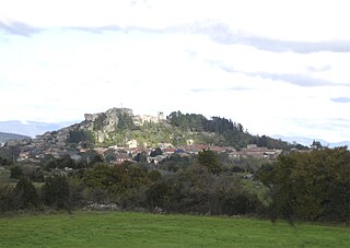
Pérouges is a commune in the Ain department in the Auvergne-Rhône-Alpes region in Eastern France. A medieval walled town perched on a small hill that overlooks the plain of the river Ain, it is located 30 km (19 mi) northeast of Lyon, historically in the neighbouring Rhône department. In 2019, Pérouges had a population of 1,273.

<span class="mw-page-title-main">Cardaillac</span> Commune in Occitania, France

Cardaillac is a commune in the Lot department in south-western France.

<span class="mw-page-title-main">Arrondissement of Béziers</span> Arrondissement in Occitania, France

The arrondissement of Béziers is an arrondissement of France in the Hérault department in the Occitanie région. Its INSEE code is 341 and its capital city is Béziers. It has 153 communes. Its population is 309,800 (2016), and its area is 3,091.2 km2 (1,193.5 sq mi).

<span class="mw-page-title-main">Les Plus Beaux Villages de France</span> Association of the most beautiful villages in France

Les Plus Beaux Villages de France is an independent association created in 1982 for the promotion of the tourist appeal of small rural villages with a rich cultural heritage. As of 2024, it numbers 176 member villages. It is affiliated to the international association The Most Beautiful Villages in the World.

<span class="mw-page-title-main">Apremont-sur-Allier</span> Commune in Centre-Val de Loire, France

Apremont-sur-Allier is a commune in the Cher department in the Centre-Val de Loire region of France.

<span class="mw-page-title-main">Lavardin, Loir-et-Cher</span> Commune in Centre-Val de Loire, France

Lavardin is a commune in the Loir-et-Cher department of central France. It is located on the banks of the river Loir. It is a member of Les Plus Beaux Villages de France Association.

<span class="mw-page-title-main">Gargilesse-Dampierre</span> Commune in Centre-Val de Loire, France

Gargilesse-Dampierre is a commune in the Indre department in central France.

<span class="mw-page-title-main">Ansouis</span> Commune in Provence-Alpes-Côte dAzur, France

Ansouis is a commune in the Vaucluse department in the Provence-Alpes-Côte d'Azur region in southeastern France.

<span class="mw-page-title-main">Minerve, Hérault</span> Commune in Occitania, France

Minerve is a commune in the Hérault department in the Occitanie region in southern France. It is the namesake of the Minervois wine region.

<span class="mw-page-title-main">Coaraze</span> Commune in Provence-Alpes-Côte dAzur, France

Coaraze is a commune in the Alpes-Maritimes department in the Provence-Alpes-Côte d'Azur region in southeastern France.

<span class="mw-page-title-main">Aiguèze</span> Commune in Occitanie, France

Aiguèze is a commune in the Gard department in the Occitanie region of Southern France. Since 2005, Aiguèze has been a member of Les Plus Beaux Villages de France, the first such location in Gard.

<span class="mw-page-title-main">Le Caylar</span> Commune in Occitania, France

Le Caylar, also known as Le Caylar-en-Larzac, is a commune in the Hérault department in southern France, in the administrative region of Occitanie. It has the Village étape label since 2013.

<span class="mw-page-title-main">Aigne</span> Commune in Occitania, France

Aigne is a commune in the Hérault department in the Occitanie region of southern France.

<span class="mw-page-title-main">Moncontour, Côtes-d'Armor</span> Commune in Brittany, France

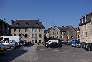
Moncontour is a commune in the Côtes-d'Armor department of Brittany in northwestern France. The 18th-century French economist Joachim Faiguet de Villeneuve [1703–1781) was born in Moncontour. It is one of Les Plus Beaux Villages de France.

<span class="mw-page-title-main">La Romieu</span> Commune in Occitania, France

La Romieu is a commune in the Gers department in southwestern France. It is a member of Les Plus Beaux Villages de France Association.

<span class="mw-page-title-main">Gerberoy</span> Commune in Hauts-de-France, France

Gerberoy is a commune in the Oise department in northern France, in the old pays of Beauvaisis.

<span class="mw-page-title-main">Angles-sur-l'Anglin</span> Commune in Nouvelle-Aquitaine, France

Angles-sur-l'Anglin is a commune in the Vienne department in the Nouvelle-Aquitaine region in western France. It is a member of Les Plus Beaux Villages de France Association.

<span class="mw-page-title-main">Castelnou, Pyrénées-Orientales</span> Commune in Occitania, France

Castelnou is a commune in the Pyrénées-Orientales department in southern France.

References

  1. "Répertoire national des élus: les maires". data.gouv.fr, Plateforme ouverte des données publiques françaises (in French). 2 December 2020.
  2. "Populations légales 2021" (in French). The National Institute of Statistics and Economic Studies. 28 December 2023.
  3. Les plus beaux villages de France
  4. Population en historique depuis 1968, INSEE