Old Mission, Michigan

Last updated

Old Mission, Michigan
Old Mission road sign (Old Mission, MI).jpg
Road signage along Mission Road
USA Michigan location map.svg
Red pog.svg
Old Mission
Usa edcp location map.svg
Red pog.svg
Old Mission
Coordinates: 44°57′44″N85°29′07″W / 44.96222°N 85.48528°W / 44.96222; -85.48528 Coordinates: 44°57′44″N85°29′07″W / 44.96222°N 85.48528°W / 44.96222; -85.48528
Country Flag of the United States.svg United States
State Flag of Michigan.svg  Michigan
County Flag of Grand Traverse County, Michigan.svg Grand Traverse
Township Peninsula
Settled1838
Elevation
[1]
587 ft (179 m)
Time zone UTC-5 (Eastern (EST))
  Summer (DST) UTC-4 (EDT)
ZIP code(s)
49673
49686 (Traverse City)
Area code 231
GNIS feature ID634007 [1]

Old Mission is an unincorporated community in Grand Traverse County in the U.S. state of Michigan. [1] It is located within Peninsula Township near the tip of Old Mission Peninsula along the shores of the East Arm of Grand Traverse Bay. As an unincorporated community, Old Mission has no legally defined boundaries or population statistics of its own.

Contents

History

In the Treaty of Washington in 1836, the federal government agreed to provide local native tribes with both a mission and schools for their reservation. Henry Schoolcraft, the Indian agent representing the government, selected a natural harbor on the eastern shore of the peninsula in Grand Traverse Bay for the planned facilities. In 1838, the Presbyterian Board of Missions, sent the Reverend Peter Dougherty (1805–1894) to establish the mission, now known as Old Mission, for which the peninsula would eventually become known.[ citation needed ]

The Dougherty Mission House, also known as the Rushmore House and Inn, was built within the community in 1842. The house and surrounding structures currently serve as a museum. The Old Mission Inn, built is 1887, is also a historic structure within Old Mission. The two are listed on the National Register of Historic Places and as Michigan State Historic Sites.

The area received its first post office on April 26, 1850 under the name Old Mission. The post office remains in operation and is located at 4007 Swaney Road. [2] Currently, the post office uses the 49673 ZIP Code, which is used for post office box only and has no delivery. [3] The area is served by the Traverse City 49686 ZIP Code. [4] [5]

Geography

Old Mission is located just east of M-37 near the tip of Old Mission Peninsula about 16 miles (25.75 km) north of Traverse City. The community was built along Old Mission Harbor, which is a small safe haven along the East Arm of Grand Traverse Bay. [6] [7] The community sits at an elevation of 587 feet (179 m) above sea level. [1]

The community is located within an American Viticultural Area and a center of the Michigan wine industry, including the Old Mission Peninsula AVA. Mission Point Light is located slightly north at the northern terminus of M-37. The 45th parallel is slightly north of Old Mission.

Climate

Climate data for Old Mission 3 SSW, Michigan (1991–2020 normals, extremes 1979–present)
MonthJanFebMarAprMayJunJulAugSepOctNovDecYear
Record high °F (°C)54
(12)
65
(18)
84
(29)
85
(29)
92
(33)
95
(35)
97
(36)
99
(37)
92
(33)
87
(31)
76
(24)
65
(18)
99
(37)
Average high °F (°C)29.5
(−1.4)
30.8
(−0.7)
40.6
(4.8)
52.3
(11.3)
65.6
(18.7)
75.5
(24.2)
79.9
(26.6)
78.6
(25.9)
71.4
(21.9)
57.8
(14.3)
46.1
(7.8)
35.2
(1.8)
55.3
(12.9)
Daily mean °F (°C)23.0
(−5.0)
23.4
(−4.8)
31.4
(−0.3)
41.8
(5.4)
54.1
(12.3)
63.9
(17.7)
68.8
(20.4)
68.3
(20.2)
61.2
(16.2)
49.5
(9.7)
39.3
(4.1)
29.9
(−1.2)
46.2
(7.9)
Average low °F (°C)16.5
(−8.6)
15.9
(−8.9)
22.2
(−5.4)
31.3
(−0.4)
42.6
(5.9)
52.4
(11.3)
57.7
(14.3)
58.1
(14.5)
50.9
(10.5)
41.3
(5.2)
32.5
(0.3)
24.5
(−4.2)
37.2
(2.9)
Record low °F (°C)−14
(−26)
−20
(−29)
−16
(−27)
8
(−13)
23
(−5)
31
(−1)
36
(2)
34
(1)
27
(−3)
21
(−6)
13
(−11)
−5
(−21)
−20
(−29)
Average precipitation inches (mm)1.78
(45)
1.18
(30)
1.43
(36)
2.81
(71)
3.05
(77)
3.02
(77)
2.78
(71)
3.32
(84)
3.61
(92)
3.98
(101)
2.36
(60)
2.00
(51)
31.32
(796)
Source: NOAA [8] [9]

Education

The area is served by Traverse City Area Public Schools, with high school students in Old Mission zoned to Traverse City Central High School. There are no public schools located on Old Mission Peninsula. [10]

Images

Further reading

Related Research Articles

<span class="mw-page-title-main">Peninsula Township, Michigan</span> Civil township in Michigan, United States

Peninsula Township, which comprises the Old Mission Peninsula, is a civil township of Grand Traverse County in the U.S. state of Michigan. Located in the Northern Lower Peninsula, Peninsula Township is part of the Traverse City micropolitan area, sharing a southern border with Traverse City. Peninsula Township had a population of 6,068 as of the 2020 census, an increase from 5,433 at the 2010 census. The township is well known for its cherry harvest and viticulture, and is included in the Old Mission Peninsula AVA, a federally recognized viticultural region.

<span class="mw-page-title-main">Allouez Township, Michigan</span> Civil township in Michigan, United States

Allouez Township is a civil township of Keweenaw County in the U.S. state of Michigan. The population was 1,340 at the 2020 census.

<span class="mw-page-title-main">Leelanau Township, Michigan</span> Civil township in Michigan, United States

Leelanau Township is a civil township of Leelanau County in the U.S. state of Michigan. At the northern tip of the Leelanau Peninsula, Leelanau Township is part of Northern Michigan, and is home to the village of Northport. Leelanau Township also includes the Fox Islands, as well as mainland shorelines on both Lake Michigan and Grand Traverse Bay. The township population was 1,552 at the 2020 census.

<span class="mw-page-title-main">Newport, Michigan</span> Unincorporated community in Michigan, United States

Newport is an unincorporated community in Monroe County in the U.S. state of Michigan. The community is located within Berlin Charter Township. As an unincorporated community, Newport has no legally defined boundaries or population statistics of its own but does have its own post office with the 48166 ZIP Code.

<span class="mw-page-title-main">Copper Harbor, Michigan</span> Census-designated place & unincorporated community in Michigan, United States

Copper Harbor is an unincorporated community and census-designated place (CDP) located in Keweenaw County in the U.S. state of Michigan. It is located within Grant Township. The population of the CDP was 136 as of the 2020 census.

<span class="mw-page-title-main">Riverdale, Michigan</span> Census-designated place & unincorporated community in Michigan, United States

Riverdale is an unincorporated community and census-designated place (CDP) in Gratiot County in the U.S. state of Michigan. The population of the CDP was 281 at the 2020 census. The community is located within Seville Township.

<span class="mw-page-title-main">Elm Hall, Michigan</span> Census-designated place & unincorporated community in Michigan, United States

Elm Hall is an unincorporated community and census-designated place (CDP) in Gratiot County in the U.S. state of Michigan. The CDP had a population of 279 at the 2020 census. The community is located within Sumner Township.

<span class="mw-page-title-main">Grand Traverse Bay</span> Bay on Lake Michigan in Grand Traverse County, Michigan, United States

Grand Traverse Bay is a deep bay of Lake Michigan formed by the Leelanau Peninsula in the northwestern Lower Peninsula of Michigan. The bay is 32 miles (51 km) long, 10 mi (16 km) wide, and up to 620 feet (190 m) deep in spots. It is further divided into two east and west arms by the Old Mission Peninsula. The entire bay is conterminous with the Grand Traverse Bay Bottomland Preserve. It should not be confused with Grand Traverse Bay of Lake Superior, located on the Keweenaw Peninsula.

<span class="mw-page-title-main">Helmer, Michigan</span> Unincorporated community in Michigan, United States

Helmer is an unincorporated community in Luce County in the U.S. state of Michigan. The community is located within Lakefield Township. As an unincorporated community, Helmer has no legally defined boundaries or population statistics of its own.

<span class="mw-page-title-main">Eureka, Michigan</span> Census-designated place & unincorporated community in Michigan, United States

Eureka is an unincorporated community and census-designated place (CDP) in Clinton County in the U.S. state of Michigan. The community is located within Greenbush Township. As an unincorporated community, Eureka has no legal autonomy of its own but does have its own post office with the 48833 ZIP Code.

<span class="mw-page-title-main">Curran, Michigan</span> Unincorporated community in Michigan, United States

Curran is an unincorporated community in Alcona County in the U.S. state of Michigan. The community is located within Mitchell Township. As an unincorporated community, Curran has no legally defined boundaries or population statistics of its own but does have its own post office with the 48728 ZIP Code.

<span class="mw-page-title-main">Elmira, Michigan</span> Unincorporated community in Michigan, United States

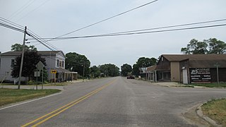
Elmira is an unincorporated community in the U.S. state of Michigan. Located along M-32, the community is on the county line between Warner Township in Antrim County to the west and Elmira Township in Otsego County to the east.

<span class="mw-page-title-main">Merritt, Michigan</span> Unincorporated community in Michigan, United States

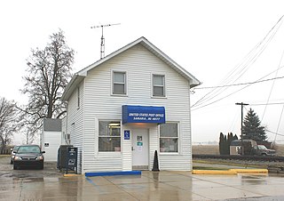
Merritt is an unincorporated community in Missaukee County in the U.S. state of Michigan. The community is centered between Butterfield Township to the south and Enterprise Township to the north. As an unincorporated community, Merritt has no legally defined boundaries or population statistics of its own but does have its own post office with the 49667 ZIP Code.

<span class="mw-page-title-main">Naubinway, Michigan</span> Census-designated place & unincorporated community in Michigan, United States

Naubinway is an unincorporated community and census-designated place (CDP) in Mackinac County in the U.S. state of Michigan. The population of the CDP was 147 at the 2020 census. The community is located within Garfield Township.

<span class="mw-page-title-main">Epoufette, Michigan</span> Unincorporated community in Michigan, United States

Epoufette is an unincorporated community in Mackinac County in the U.S. state of Michigan. The community is located along the northern shores of Lake Michigan along U.S. Route 2 within Hendricks Township. As an unincorporated community, Epoufette has no legally defined boundaries or population statistics of its own.

<span class="mw-page-title-main">Luzerne, Michigan</span> Unincorporated community in Michigan, United States

Luzerne is an unincorporated community in Oscoda County in the U.S. state of Michigan. The community is located within Big Creek Township. As an unincorporated community, Luzerne has no legally defined boundaries or population statistics of its own but does have its own post office with the 48636 ZIP Code.

<span class="mw-page-title-main">Samaria, Michigan</span> Unincorporated community in Michigan, United States

Samaria is an unincorporated community in Monroe County in the U.S. state of Michigan. The community is located within Bedford Township. As an unincorporated community, Samaria has no legally defined boundaries or population statistics of its own but does have its own post office with the 48177 ZIP Code.

<span class="mw-page-title-main">Ocean View, New Jersey</span> Unincorporated community in New Jersey, United States

Ocean View is an unincorporated community located within Dennis Township in Cape May County, New Jersey, United States. The area is served as United States Postal Service ZIP code 08230. The post office was established in 1872, with William Doolittle as the first postmaster.

Garwood is an unincorporated community in Colorado County, Texas, United States. It is located on State Highway 71 at virtually the geographic midpoint between Columbus, Texas and El Campo, Texas. Nearly 1,000 people lived in Garwood in 2000.

<span class="mw-page-title-main">Dougherty Mission House</span> Historic house in Michigan, United States

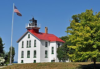
The Dougherty Mission House is a house located at 18459 Mission Road in Peninsula Township, Michigan. It was designated a Michigan State Historic Site in 1956 and listed on the National Register of Historic Places in 2011. The house was certainly one of the first frame buildings constructed in Grand Traverse County, and is thought to be the first post and beam house constructed in Michigan's lower peninsula north of Grand Rapids.

References

  1. 1 2 3 4 "Old Mission". Geographic Names Information System . United States Geological Survey, United States Department of the Interior.
  2. U.S. Geological Survey Geographic Names Information System: Old Mission Post Office
  3. UnitedStatesZipCodes.org (2020). "ZIP Code 49673: Old Mission" . Retrieved 16 October 2020.
  4. Google (20 October 2020). "49686 ZIP Code map" (Map). Google Maps . Google. Retrieved 20 October 2020.
  5. UnitedStatesZipCodes.org (2020). "ZIP Code 49686: Traverse City" . Retrieved 16 October 2020.
  6. U.S. Geological Survey Geographic Names Information System: Old Mission Harbor
  7. U.S. Geological Survey Geographic Names Information System: Old Mission Peninsula
  8. "NowData - NOAA Online Weather Data". National Oceanic and Atmospheric Administration. Retrieved 28 August 2021.
  9. "Station: Old Mission 3SSW, MI". U.S. Climate Normals 2020: U.S. Monthly Climate Normals (1991-2020). National Oceanic and Atmospheric Administration. Retrieved 28 August 2021.
  10. Traverse City Area Public Schools (2020). "TCAPS: Boundary map" (PDF). Retrieved 21 October 2020.