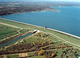
Liverpool is a lakeside village in Onondaga County, New York, United States. As of the 2020 census, the population was 2,242. The name was adopted from the city of Liverpool in the United Kingdom. The village is on Onondaga Lake, in the western part of the town of Salina and is northwest of Syracuse, of which it is a suburb.

Onondaga Lake is a lake in Central New York, immediately northwest of and adjacent to Syracuse, New York. The southeastern end of the lake and the southwestern shore abut industrial areas and expressways; the northeastern shore and northwestern end border a series of parks and museums.

Otisco Lake is the easternmost of New York's eleven Finger Lakes. The 2,048-acre (8.29 km2) lake is located in Onondaga County, southwest of the city of Syracuse.

The Folsom Lake State Recreation Area surrounds Folsom Lake in the foothills of the Sierra Nevada, and is managed by the California Department of Parks and Recreation. It is located near the city of Folsom, California, about 25 miles (40 km) east of Sacramento.

The Oregon Coast Trail (OCT) is a long-distance hiking route along the Pacific coast of the U.S. state of Oregon in the United States. It follows the coast of Oregon from the mouth of the Columbia River to the California border south of Brookings.

The Conecuh National Forest in southern Alabama covers 83,000 acres (340 km2), along the Alabama - Florida line in Covington and Escambia counties. Topography is level to moderately sloping, broad ridges with stream terraces and broad floodplains.

Cedar Lake is a lake in Minneapolis, Minnesota, United States, and part of the city's Chain of Lakes. It is located on the west side of the city, north of Bde Maka Ska and west of Lake of the Isles. The lake is surrounded by parkland, with some easements having been made to private homeowners on the southeast side; it is the only lake in the city with private shoreline. The south and west sides border the Cedar-Isles-Dean neighborhood, while the east shore flanks the Kenwood residential area. On the north is the Cedar Lake Trail and the BNSF Railway, and the south Bryn Mawr neighborhood. Cedar Lake has an area of 169 acres (0.68 km2) and a maximum depth of 51 feet (16 m). The Minneapolis Park and Recreation Board manages the lake and parkland around the lake.

The OC&E Woods Line State Trail is a rail trail in Klamath and Lake counties in the U.S. state of Oregon. It is Oregon's longest state park. The trail follows the old OC&E and Weyerhaeuser railroads from Klamath Falls to Thompson Reservoir. Along its 105-mile (169 km) length it passes through the communities of Olene, Sprague River, Dairy, Beatty, and Bly.

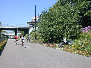
Cedar Lake Trail is a 4.3-mile (6.9 km), shared-use path in the U.S. state of Minnesota, from downtown Minneapolis to the neighboring suburb of St. Louis Park. The trail begins at its eastern trailhead in downtown Minneapolis (44°59′11″N93°16′01″W) and continues west to Minnesota State Highway 100 in St. Louis Park (44°57′43″N93°20′36″W). At the trail's west end, a paved path continues for another 4.2 miles (6.8 km) through St. Louis Park to Hopkins under the former name of Hutchinson Spur Trail, but known as North Cedar Lake Regional Trail since 2009. In 2019, large portions of the Cedar Lake Trail were closed due to construction of the Southwest LRT extension with expected reopening in 2021 or 2022.
This is a list of trails in Ithaca, New York.

Three Rivers Park District is a special park district serving the suburban areas of the Twin Cities including suburban Hennepin, Carver, Dakota, Scott, and Ramsey counties. Three Rivers's mission is "To promote environmental stewardship through recreation and education in a natural resources-based park system." Three Rivers operates twenty parks and ten regional trails, with at least two more regional trails planned. Nearly seven million people visit Three Rivers facilities each year. It has over 27,000 acres (11,000 ha) of parks and trails.

Perry Lake is a US Army Corps of Engineers operated reservoir in northeast Kansas. Its primary purposes are flood control, water reserve for nearby areas and regional recreation. The lake is approximately 11,150 acres (45 km²) in size, with over 160 miles (260 km) of shoreline. Perry Lake's full multi-purpose pool elevation is 891.5 feet (271.7 m) above sea level. Perry Lake is located about 40 miles (64 km) west of Kansas City, just northwest of Lawrence, Kansas. Its close proximity to Kansas City, Lawrence, and the state capitol, Topeka, make it a very popular destination, with the nickname "Paradise on the Plains".

New York State Route 174 (NY 174) is a state highway in Onondaga County, located in Central New York, in the United States. The highway is 16.7 miles (26.9 km) long and passes through mostly rural regions. Route 174 begins at an intersection with NY 41 in Borodino, a hamlet of Spafford. It heads generally northward for most of its length, except for short distances in the villages of Marcellus and Camillus. The route ends at a junction with NY 5 west of Camillus, at the west end of the Route 5 Camillus bypass. Route 174 is located along a large mapped sedimentary bedrock unit, known as the Marcellus Formation. The formation is named for an outcrop found near the town of Marcellus, New York, during a geological survey in 1839.
Lake Perris is an artificial lake completed in 1973. It is the southern terminus of the California State Water Project, situated in a mountain-rimmed valley between Moreno Valley and Perris, in what is now the Lake Perris State Recreation Area. The park offers a variety of recreational activities. Because of this and the lake's proximity to major population centers, it is very crowded during the summer months.

Long Branch Park is a public park in Onondaga County outside of Syracuse, New York, located in the town of Geddes, New York on Long Branch Road near NYS Route 370 and John Glenn Boulevard. The park is situated on the northern shore of Onondaga Lake and is often misidentified as an extension of Onondaga Lake Park which wraps around the eastern shore of the lake to the south shore.

John Redmond Reservoir is a reservoir on the Neosho River in eastern Kansas. Built and managed by the U.S. Army Corps of Engineers, it is used for flood control, recreation, water supply, and wildlife management. It borders the Flint Hills National Wildlife Refuge to the northwest.
The Radnor Trail is a 2.4-mile-long (3.9 km) rail trail that travels through Radnor Township in south-eastern Pennsylvania. The former Philadelphia & Western Railroad line is paved and has multiple entry points and parking at the Conestoga Road entry point.

The Onondaga Creekwalk is a mostly paved, partly bricked, multi-use trail running 4.8 miles (7.7 km) in Syracuse, New York, which has so far seen more than three decades of planning, construction, and delays, starting in 1988. The trail is designed for bicyclists, skaters, and pedestrians to approximately parallel any desired portion of Onondaga Creek's run connecting Kirk Park on Syracuse's South Side, downstream through downtown at Armory Square, and then on to Onondaga Lake at the creek's ultimate mouth.

Minnehaha Trail is a 1.5-mile (2.4 km) paved, multi-use trail in Minneapolis, Minnesota, United States, that connects Minnehaha Regional Park and Fort Snelling State Park – two of the most popular recreation destinations in the Twin Cities metro area. The trail is considered a segment of a longer, loosely connected bicycle route system along the Mississippi River. Users of Minnehaha Trail traverse under a forest canopy. The trail received local recognition for its natural beauty, but it was criticized for its worn pavement and lack of signage.

Minneapolis is often considered one of the top biking and walking cities in the United States due to its vast network of trails and dedicated pedestrian areas. In 2020, Walk Score rated Minneapolis as 13th highest among cities over 200,000 people. Some bicycling ratings list Minneapolis at the top of all United States cities, while others list Minneapolis in the top ten. There are over 80 miles (130 km) of paved, protected pathways in Minneapolis for use as transportation and recreation. The city's Grand Rounds National Scenic Byway parkway system accounts for the vast majority of the city's shared-use paths at approximately 50 miles (80 km) of dedicated biking and walking areas. By 2008, other city, county, and park board areas accounted for approximately 30 miles (48 km) of additional trails, for a city-wide total of approximately 80 miles (130 km) of protected pathways. The network of shared biking and walking paths continued to grow into the late 2010s with the additions of the Hiawatha LRT Trail gap remediation, Min Hi Line pilot projects, and Samatar Crossing. The city also features several natural-surface hiking trails, mountain-biking paths, groomed cross-country ski trails in winter, and other pedestrian walkways.


